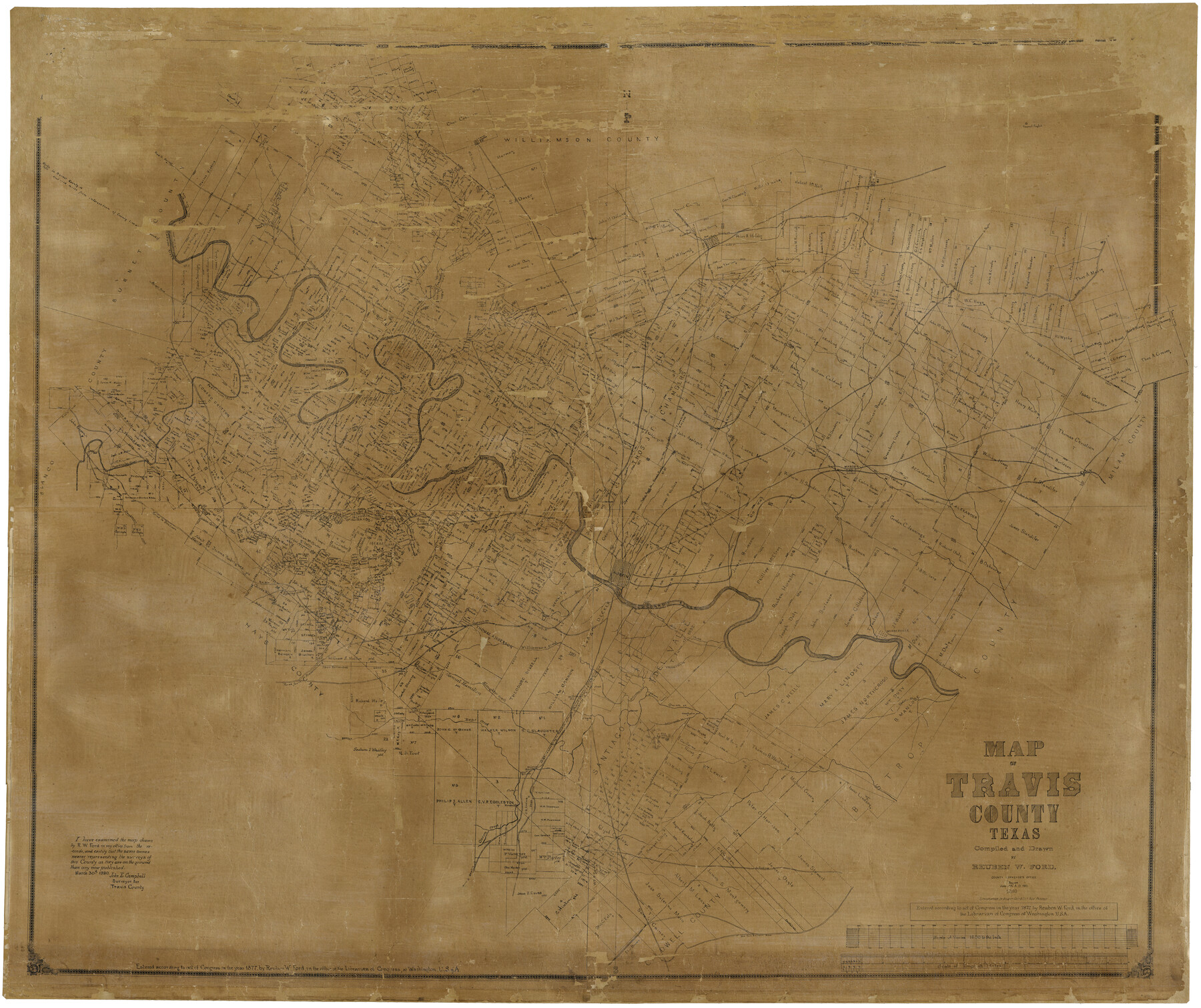
Travis County
-
Map/Doc
16902
-
Collection
General Map Collection
-
Object Dates
1880 (Creation Date)
-
People and Organizations
Reuben W. Ford (Compiler)
Reuben W. Ford (Draftsman)
August Gast & Co. (Lithographer)
-
Counties
Travis
-
Subjects
County
-
Height x Width
59.0 x 70.2 inches
149.9 x 178.3 cm
-
Comments
Map begun in 1877.
Conservation funded in 2004 with donation from Hilgers and Watkins, P. C. and Friends of the Texas General Land Office.
Digitized in 2012 with a generous grant from the Summerlee Foundation. -
Features
Bear Creek
Taylor
Bagdad Post Office
Old San Antonio Road
Saint Elmo Post Office
Fredericksburg Road
Slaughter Creek
Williamson Creek
Mountain City Road
Road to Bastrop
Manchaca School
Onion Creek Post Office
Cross Creek
Pilot Knob
Cedar Creek
Cottonmouth Branch of Onion Creek
Onion Creek
Webberville
Austin
Grape Creek
Spring Creek
Road to Birdtown
Deadman's Creek
Basoner Creek
Public Road to Round Rock and Georgetown
Manchaca Station
[Road] to Mountain City
Road from Fredericksburg
Thomas's Branch
Shrine Creek
Goatman Post Office
Waller Creek
Shoal Creek
Mount Bonnell
Cascade Creek
Honey Creek
Shingle Hills
Shoal Creek
Jourdan House
Phluegerville [sic]
Duval
Falls Creek
Corwin's Mill
Rice's Crossing
Cherry Brush Creek
Newton
Forty Acre Hollow
J. P. Dode's Post Office
Dell Creek
Corwin's Mill Post Office
Red Bank Creek
Flat Creek
Road to Burnet
[Road to] Hutto
[Road] to Taylor
Lake Creek
New Round Rock
Old Round Rock
Road to Georgetown
Anderson's Mill Post Office
Brushy Creek
Cow Creek
Post Oak Creek
Colorado River
Travis Peak Post Office
Cherry Creek
Cherry Hollow Creek
Sandy Creek
Hutto Station Post Office
Bagdad
Spicewood Spring
Bee Cave Post Office
Round Rock Road
Wilbarger Creek
Road to Hogeye
Elgin
Willow Creek
Cottonwood Creek
Manor
Gilleland's Creek
Little Walnut Creek
Fiskville Post Office
Long Hollow Creek
Hurst Creek
Bee Creek
Cypress Creek
Pedernales River
Dessau Settlement
Harris's Branch
[Road to] Rockdale
Elm Creek
Merrilltown Post Office
Jolleville [sic]
Part of: General Map Collection
Clay County Sketch File 7

Print $2.00
- Digital $50.00
Clay County Sketch File 7
Size 8.2 x 3.5 inches
Map/Doc 18397
Concho County Rolled Sketch 20

Print $20.00
- Digital $50.00
Concho County Rolled Sketch 20
1968
Size 26.2 x 38.8 inches
Map/Doc 5554
Map of Wilson County

Print $20.00
- Digital $50.00
Map of Wilson County
1840
Size 24.4 x 21.0 inches
Map/Doc 4154
Mills County Sketch File 24

Print $20.00
- Digital $50.00
Mills County Sketch File 24
Size 19.2 x 21.0 inches
Map/Doc 12094
Coleman County Sketch File 7

Print $2.00
- Digital $50.00
Coleman County Sketch File 7
Size 8.2 x 10.3 inches
Map/Doc 18674
Rusk County Sketch File 19a

Print $4.00
Rusk County Sketch File 19a
1860
Size 8.2 x 6.6 inches
Map/Doc 35528
Brewster County Rolled Sketch 155

Print $20.00
- Digital $50.00
Brewster County Rolled Sketch 155
Size 36.8 x 24.7 inches
Map/Doc 78343
Zapata County Working Sketch 24

Print $20.00
- Digital $50.00
Zapata County Working Sketch 24
1992
Size 28.2 x 23.9 inches
Map/Doc 62075
San Augustine County Sketch File 18

Print $6.00
San Augustine County Sketch File 18
Size 14.4 x 8.9 inches
Map/Doc 35675
Garza County Rolled Sketch R-2

Print $40.00
- Digital $50.00
Garza County Rolled Sketch R-2
Size 36.0 x 50.2 inches
Map/Doc 9046
Gaines County Working Sketch 4

Print $20.00
- Digital $50.00
Gaines County Working Sketch 4
1939
Size 44.5 x 43.1 inches
Map/Doc 69304
Map of Smith County

Print $20.00
- Digital $50.00
Map of Smith County
1872
Size 20.0 x 20.6 inches
Map/Doc 4625
You may also like


Van Zandt County Boundary File 90

Print $10.00
- Digital $50.00
Van Zandt County Boundary File 90
Size 9.5 x 4.0 inches
Map/Doc 59650
Montgomery County Sketch File 33A

Print $20.00
- Digital $50.00
Montgomery County Sketch File 33A
1948
Size 21.3 x 28.3 inches
Map/Doc 42124
Foard County Rolled Sketch 15A

Print $20.00
- Digital $50.00
Foard County Rolled Sketch 15A
1889
Size 37.3 x 39.8 inches
Map/Doc 75936
Tarrant County Working Sketch 4

Print $20.00
- Digital $50.00
Tarrant County Working Sketch 4
1952
Size 20.6 x 19.7 inches
Map/Doc 62421
Tom Green County Rolled Sketch 23

Print $20.00
- Digital $50.00
Tom Green County Rolled Sketch 23
Size 19.1 x 21.9 inches
Map/Doc 8005
[Plat of Trinity River w/ Midstream Profile in Liberty County by US Government 1899]
![65337, [Plat of Trinity River w/ Midstream Profile in Liberty County by US Government 1899], General Map Collection](https://historictexasmaps.com/wmedia_w700/maps/65337.tif.jpg)
Print $20.00
- Digital $50.00
[Plat of Trinity River w/ Midstream Profile in Liberty County by US Government 1899]
1899
Size 12.3 x 16.7 inches
Map/Doc 65337
[H. & G. N. Block 8 showing Llano and Espuella fence lines]
![90375, [H. & G. N. Block 8 showing Llano and Espuella fence lines], Twichell Survey Records](https://historictexasmaps.com/wmedia_w700/maps/90375-1.tif.jpg)
Print $2.00
- Digital $50.00
[H. & G. N. Block 8 showing Llano and Espuella fence lines]
Size 8.7 x 11.0 inches
Map/Doc 90375
General Highway Map, McCulloch County, Texas

Print $20.00
General Highway Map, McCulloch County, Texas
1961
Size 25.0 x 19.3 inches
Map/Doc 79588
Harris County Sketch File 68

Print $20.00
- Digital $50.00
Harris County Sketch File 68
1939
Size 22.9 x 10.6 inches
Map/Doc 11662
Stonewall County Working Sketch 11

Print $20.00
- Digital $50.00
Stonewall County Working Sketch 11
1950
Size 23.8 x 33.7 inches
Map/Doc 62318