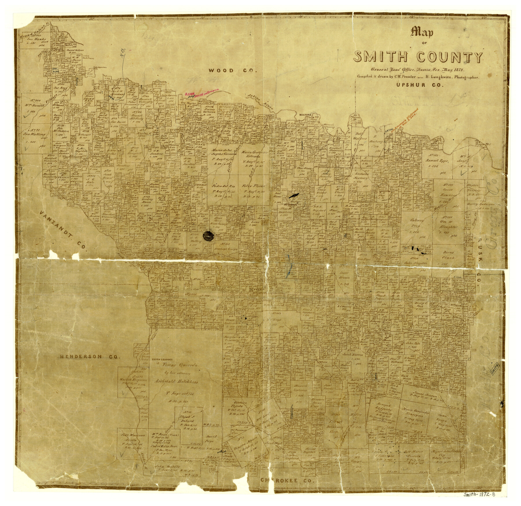
Map of Smith County
-
Map/Doc
4625
-
Collection
General Map Collection
-
Object Dates
1872 (Creation Date)
-
People and Organizations
Texas General Land Office (Publisher)
Chas. W. Pressler (Draftsman)
Herman Lungkwitz (Draftsman)
Chas. W. Pressler (Compiler)
-
Counties
Smith
-
Subjects
County
-
Height x Width
20.0 x 20.6 inches
50.8 x 52.3 cm
-
Features
Guapaw Creek
Mann's Creek
Mt. Carmel
Rabbitt Creek
Black Fork [of Prairie Creek]
Tyler
Indian Creek
Warner's Crossing
Hays Creek
Cany Creek
Seven Leagues
Troop
Striker's Creek
East Fork of Mud Creek
West Fork of Mud Creek
Saline Creek
Neches River
Grand Saline Creek
Gumspring
Garden Valley
East Fork [of Little Saline Creek]
Little Saline Creek
Harris Creek
Mill Creek
Belzora
Prairie Creek
Duck Creek
Flora
Village Creek
Rock Creek
Sabine River
Lake Robertson
Dry Creek
Part of: General Map Collection
Winkler County Rolled Sketch 12

Print $20.00
- Digital $50.00
Winkler County Rolled Sketch 12
1965
Size 24.9 x 18.5 inches
Map/Doc 8279
Williamson County Sketch File 5

Print $13.00
- Digital $50.00
Williamson County Sketch File 5
1847
Size 8.2 x 11.2 inches
Map/Doc 40306
Crockett County Rolled Sketch 55

Print $40.00
- Digital $50.00
Crockett County Rolled Sketch 55
Size 42.3 x 95.8 inches
Map/Doc 8718
Harris County Historic Topographic 9

Print $20.00
- Digital $50.00
Harris County Historic Topographic 9
1916
Size 14.6 x 24.0 inches
Map/Doc 65819
St. Louis Southwestern Railway of Texas

Print $20.00
- Digital $50.00
St. Louis Southwestern Railway of Texas
1906
Size 21.4 x 30.0 inches
Map/Doc 64450

Flight Mission No. DQN-5K, Frame 40, Calhoun County

Print $20.00
- Digital $50.00
Flight Mission No. DQN-5K, Frame 40, Calhoun County
1953
Size 18.6 x 22.1 inches
Map/Doc 84388
Val Verde County Working Sketch 67

Print $40.00
- Digital $50.00
Val Verde County Working Sketch 67
1964
Size 48.4 x 42.1 inches
Map/Doc 72202
Brewster County Sketch File 39

Print $4.00
- Digital $50.00
Brewster County Sketch File 39
Size 12.8 x 8.9 inches
Map/Doc 16300
Pecos County Working Sketch 68

Print $20.00
- Digital $50.00
Pecos County Working Sketch 68
1955
Size 41.4 x 24.0 inches
Map/Doc 71540
Karte von den Vermessungen im Grant und in der Gegend zwischen demselben und Neu Braunfels

Print $20.00
- Digital $50.00
Karte von den Vermessungen im Grant und in der Gegend zwischen demselben und Neu Braunfels
1850
Size 24.0 x 19.0 inches
Map/Doc 94446
Jeff Davis County Working Sketch 7

Print $20.00
- Digital $50.00
Jeff Davis County Working Sketch 7
1938
Size 30.4 x 39.9 inches
Map/Doc 66502
You may also like
Georgetown and the City of Washington the Capital of the United States of America

Print $20.00
- Digital $50.00
Georgetown and the City of Washington the Capital of the United States of America
1856
Size 15.7 x 18.7 inches
Map/Doc 95359
Dimmit County Sketch File 33

Print $4.00
- Digital $50.00
Dimmit County Sketch File 33
1884
Size 8.2 x 8.4 inches
Map/Doc 21151
Coke County Sketch File 2

Print $22.00
- Digital $50.00
Coke County Sketch File 2
Size 9.1 x 7.8 inches
Map/Doc 18565
Flight Mission No. BRA-16M, Frame 129, Jefferson County

Print $20.00
- Digital $50.00
Flight Mission No. BRA-16M, Frame 129, Jefferson County
1953
Size 18.4 x 22.7 inches
Map/Doc 85739
Asher & Adams' Geological Map - United States and Territories

Print $20.00
- Digital $50.00
Asher & Adams' Geological Map - United States and Territories
1874
Size 17.9 x 24.9 inches
Map/Doc 95175
Roberts County Working Sketch 40

Print $20.00
- Digital $50.00
Roberts County Working Sketch 40
1978
Size 26.6 x 22.6 inches
Map/Doc 63566
Terrell County Working Sketch 79

Print $40.00
- Digital $50.00
Terrell County Working Sketch 79
1983
Size 43.0 x 55.8 inches
Map/Doc 69600
Pecos County Sketch File 44

Print $8.00
- Digital $50.00
Pecos County Sketch File 44
Size 13.0 x 10.4 inches
Map/Doc 33743
Map of the State of Texas from the most recent authorities

Print $20.00
- Digital $50.00
Map of the State of Texas from the most recent authorities
1850
Size 13.8 x 17.3 inches
Map/Doc 89251
University Land Field Notes for Blocks 1, 2, 8, 9, and 10 in Reagan County, Blocks 6 and 7 in Crockett and Reagan Counties, Blocks 3, 4, and 58 in Reagan and Upton Counties, and Block 5 in Crockett, Reagan, and Upton Counties

University Land Field Notes for Blocks 1, 2, 8, 9, and 10 in Reagan County, Blocks 6 and 7 in Crockett and Reagan Counties, Blocks 3, 4, and 58 in Reagan and Upton Counties, and Block 5 in Crockett, Reagan, and Upton Counties
Map/Doc 81716
Hutchinson County Rolled Sketch 38

Print $40.00
- Digital $50.00
Hutchinson County Rolled Sketch 38
1953
Size 27.5 x 85.9 inches
Map/Doc 10679
Young County Working Sketch 12

Print $20.00
- Digital $50.00
Young County Working Sketch 12
1921
Size 17.6 x 19.0 inches
Map/Doc 62035