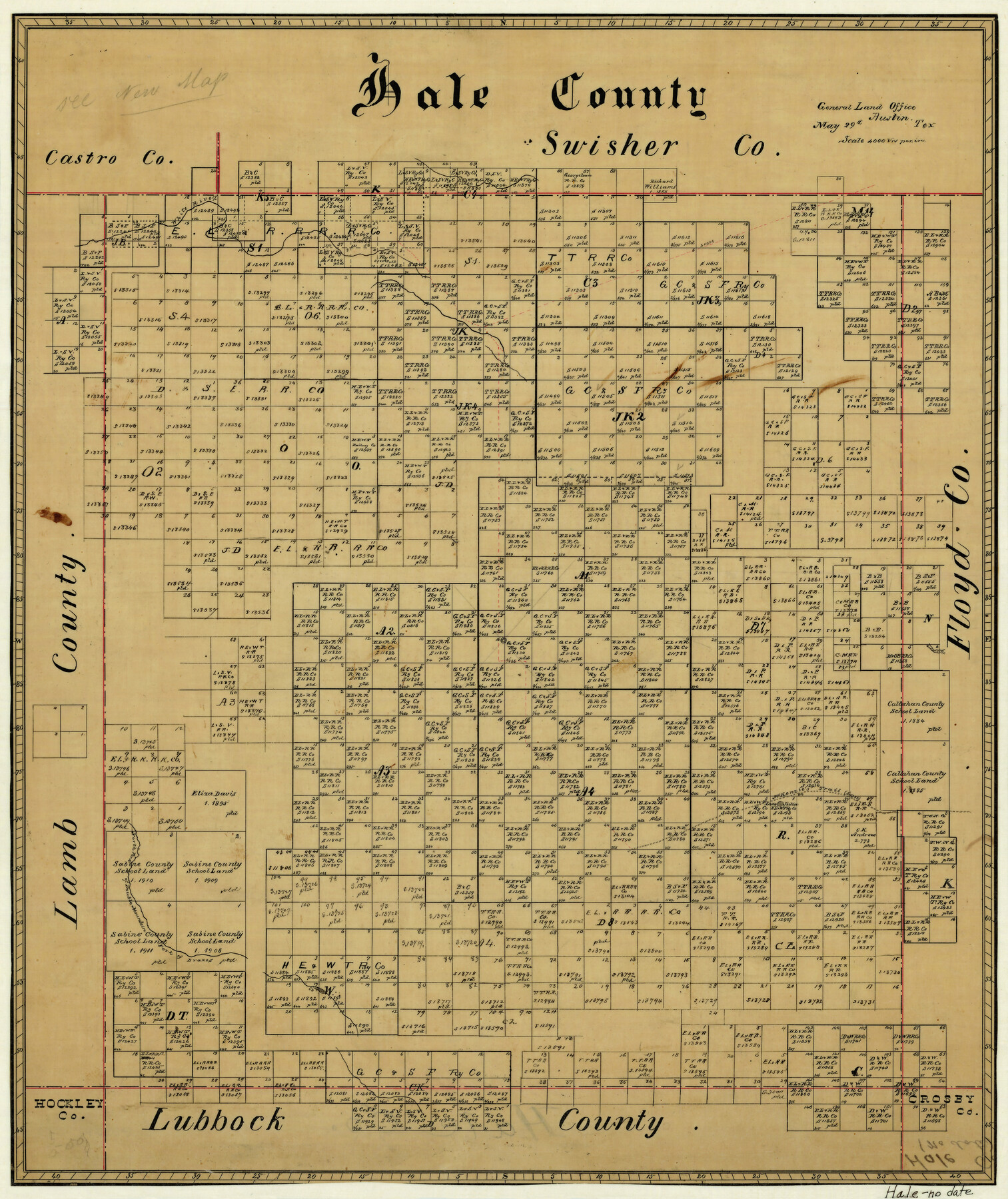
Hale County
-
Map/Doc
3614
-
Collection
General Map Collection
-
Counties
Hale
-
Subjects
County
-
Height x Width
21.8 x 18.4 inches
55.4 x 46.7 cm
-
Comments
The year was not put on the map, only the month and day, May 29th.
-
Features
White River
Goddart's Creek
North Fork of Double Mountain Fork of Brazos River
McKenzie's Trail
Lake Julia
Cora Lake
Part of: General Map Collection
Wharton County Working Sketch 23

Print $20.00
- Digital $50.00
Wharton County Working Sketch 23
1919
Size 22.0 x 36.0 inches
Map/Doc 72487
Crane County Sketch File 29

Print $6.00
- Digital $50.00
Crane County Sketch File 29
1930
Size 12.8 x 10.4 inches
Map/Doc 19608
King County Sketch File 11

Print $40.00
- Digital $50.00
King County Sketch File 11
1902
Size 13.7 x 9.1 inches
Map/Doc 29085
Flight Mission No. DQO-8K, Frame 19, Galveston County

Print $20.00
- Digital $50.00
Flight Mission No. DQO-8K, Frame 19, Galveston County
1952
Size 18.7 x 22.5 inches
Map/Doc 85142
Bandera County Working Sketch 16d

Print $20.00
- Digital $50.00
Bandera County Working Sketch 16d
1941
Size 19.1 x 23.2 inches
Map/Doc 67612
Hardin County Sketch File 37

Print $20.00
- Digital $50.00
Hardin County Sketch File 37
Size 20.4 x 17.7 inches
Map/Doc 11633
Webb County Rolled Sketch 68

Print $43.00
- Digital $50.00
Webb County Rolled Sketch 68
1910
Size 9.6 x 15.1 inches
Map/Doc 49485
Zapata County Working Sketch 4

Print $20.00
- Digital $50.00
Zapata County Working Sketch 4
1935
Size 19.6 x 22.1 inches
Map/Doc 62055

Hockley County Rolled Sketch 3

Print $40.00
- Digital $50.00
Hockley County Rolled Sketch 3
Size 82.9 x 29.4 inches
Map/Doc 9173
Loving County Rolled Sketch 17

Print $40.00
- Digital $50.00
Loving County Rolled Sketch 17
2022
Size 38.2 x 49.3 inches
Map/Doc 97292
Travis County Sketch File 54

Print $20.00
- Digital $50.00
Travis County Sketch File 54
1945
Size 23.0 x 16.5 inches
Map/Doc 12470
You may also like
Sketch from old map (authority unknown) showing a portion of the Rio Grande River and harbor of Brazos Santiago, Texas

Print $20.00
- Digital $50.00
Sketch from old map (authority unknown) showing a portion of the Rio Grande River and harbor of Brazos Santiago, Texas
1887
Size 18.4 x 24.1 inches
Map/Doc 73004
San Patricio County Sketch File 39

Print $8.00
- Digital $50.00
San Patricio County Sketch File 39
Size 12.9 x 8.4 inches
Map/Doc 36232
Texas Official Travel Map

Digital $50.00
Texas Official Travel Map
Size 33.4 x 36.4 inches
Map/Doc 94424
San Jacinto County Sketch File 4

Print $4.00
San Jacinto County Sketch File 4
1857
Size 12.9 x 7.9 inches
Map/Doc 35700
Lee County Working Sketch 12

Print $20.00
- Digital $50.00
Lee County Working Sketch 12
1980
Size 12.3 x 16.3 inches
Map/Doc 70391
Wilson County Rolled Sketch 1

Print $20.00
- Digital $50.00
Wilson County Rolled Sketch 1
1941
Size 31.5 x 27.1 inches
Map/Doc 8367
Hartley County

Print $40.00
- Digital $50.00
Hartley County
1925
Size 41.9 x 52.1 inches
Map/Doc 1851
[Maps of surveys in Reeves & Culberson Cos]
![61140, [Maps of surveys in Reeves & Culberson Cos], General Map Collection](https://historictexasmaps.com/wmedia_w700/maps/61140.tif.jpg)
Print $20.00
- Digital $50.00
[Maps of surveys in Reeves & Culberson Cos]
1937
Size 30.6 x 24.9 inches
Map/Doc 61140
Ladonia, Fannin County, Texas

Print $20.00
Ladonia, Fannin County, Texas
1891
Size 12.3 x 22.3 inches
Map/Doc 93475
[Sketch between Wheeler County and Oklahoma]
![89674, [Sketch between Wheeler County and Oklahoma], Twichell Survey Records](https://historictexasmaps.com/wmedia_w700/maps/89674-1.tif.jpg)
Print $40.00
- Digital $50.00
[Sketch between Wheeler County and Oklahoma]
Size 64.9 x 10.2 inches
Map/Doc 89674
Palo Pinto County Working Sketch 12

Print $20.00
- Digital $50.00
Palo Pinto County Working Sketch 12
1946
Size 21.1 x 33.7 inches
Map/Doc 71395
Edwards County Working Sketch 1

Print $20.00
- Digital $50.00
Edwards County Working Sketch 1
Size 12.2 x 16.4 inches
Map/Doc 68877