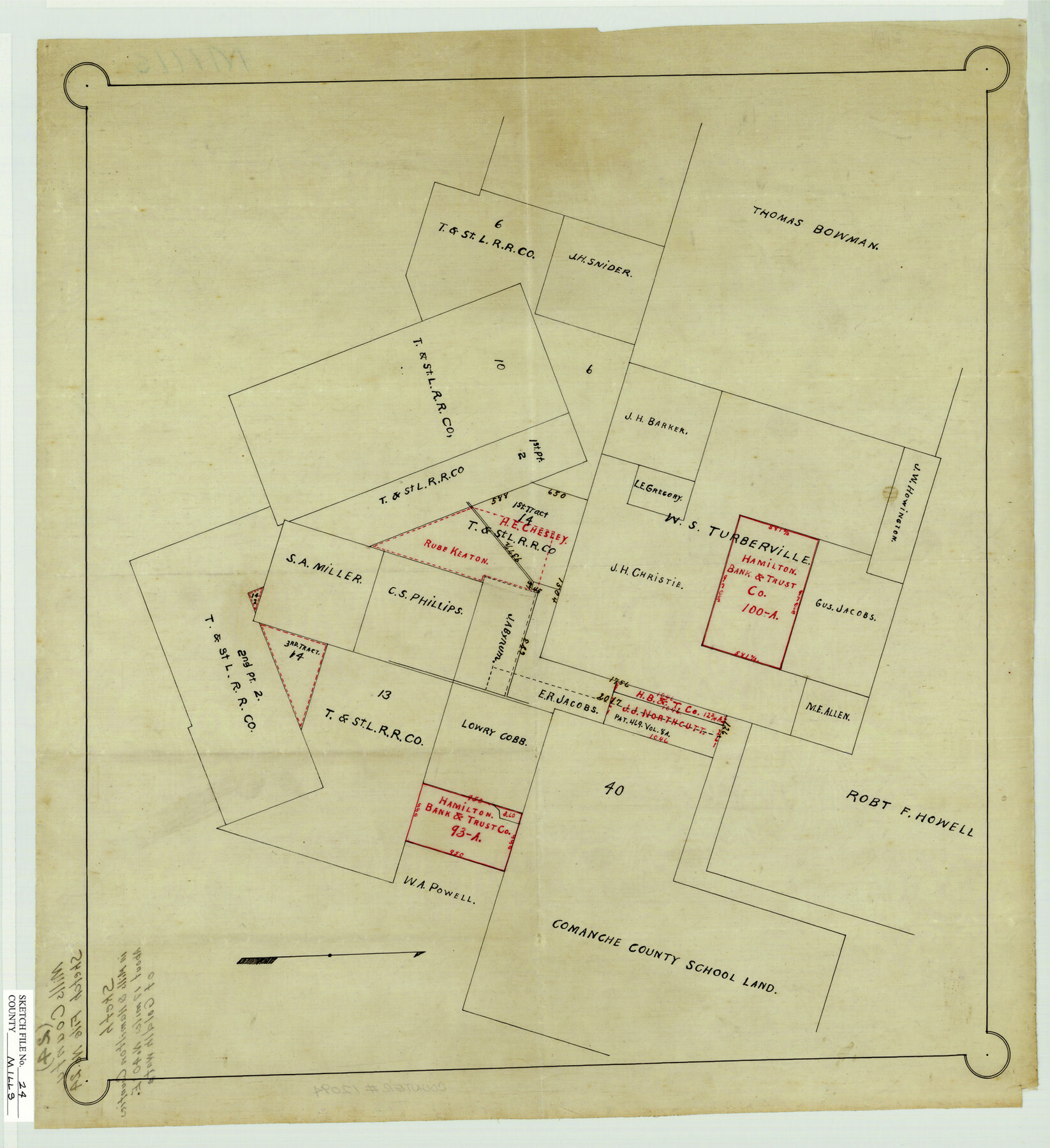
Mills County Sketch File 24
[Sketch of area around the Mills and Hamilton County line northeast of Goldthwaite]
-
Map/Doc
12094
-
Collection
General Map Collection
-
Counties
Mills Hamilton
-
Subjects
Surveying Sketch File
-
Height x Width
19.2 x 21.0 inches
48.8 x 53.3 cm
-
Medium
paper, manuscript
Part of: General Map Collection
Flight Mission No. DAG-19K, Frame 64, Matagorda County

Print $20.00
- Digital $50.00
Flight Mission No. DAG-19K, Frame 64, Matagorda County
1952
Size 16.3 x 16.3 inches
Map/Doc 86391
Real County Working Sketch 39

Print $20.00
- Digital $50.00
Real County Working Sketch 39
1951
Size 33.5 x 36.6 inches
Map/Doc 71931
Matagorda County Working Sketch 5

Print $20.00
- Digital $50.00
Matagorda County Working Sketch 5
1936
Size 18.4 x 26.9 inches
Map/Doc 70863
Map of Wichita Co.

Print $20.00
- Digital $50.00
Map of Wichita Co.
1897
Size 29.7 x 36.7 inches
Map/Doc 16925
Orange County Rolled Sketch 29

Print $20.00
- Digital $50.00
Orange County Rolled Sketch 29
1960
Size 25.9 x 37.2 inches
Map/Doc 7187
Cherokee County Working Sketch 28

Print $20.00
- Digital $50.00
Cherokee County Working Sketch 28
1991
Size 13.7 x 16.8 inches
Map/Doc 67983

Terrell County Working Sketch 6

Print $20.00
- Digital $50.00
Terrell County Working Sketch 6
1914
Size 15.7 x 21.9 inches
Map/Doc 62155
Flight Mission No. CGI-2N, Frame 182, Cameron County

Print $20.00
- Digital $50.00
Flight Mission No. CGI-2N, Frame 182, Cameron County
1954
Size 18.5 x 22.2 inches
Map/Doc 84542
Map of Runnels County

Print $20.00
- Digital $50.00
Map of Runnels County
1898
Size 43.2 x 36.9 inches
Map/Doc 16803
Panola County Working Sketch 28

Print $20.00
- Digital $50.00
Panola County Working Sketch 28
1977
Map/Doc 71437
Shelby County Working Sketch 27

Print $20.00
- Digital $50.00
Shelby County Working Sketch 27
1995
Size 32.8 x 39.9 inches
Map/Doc 63881
You may also like
General Highway Map, Hale County, Texas

Print $20.00
General Highway Map, Hale County, Texas
1940
Size 24.8 x 18.4 inches
Map/Doc 79108
Clay County Sketch File 1a

Print $25.00
- Digital $50.00
Clay County Sketch File 1a
1860
Size 8.8 x 8.2 inches
Map/Doc 18387
Current Miscellaneous File 110

Print $62.00
- Digital $50.00
Current Miscellaneous File 110
1972
Size 11.1 x 8.8 inches
Map/Doc 74713
General Highway Map. Detail of Cities and Towns in Bastrop County, Texas [Bastrop, Smithville, Elgin, etc.]
![79362, General Highway Map. Detail of Cities and Towns in Bastrop County, Texas [Bastrop, Smithville, Elgin, etc.], Texas State Library and Archives](https://historictexasmaps.com/wmedia_w700/maps/79362.tif.jpg)
Print $20.00
General Highway Map. Detail of Cities and Towns in Bastrop County, Texas [Bastrop, Smithville, Elgin, etc.]
1961
Size 18.3 x 25.0 inches
Map/Doc 79362
[Blocks 3T, 1, and 6T]
![91421, [Blocks 3T, 1, and 6T], Twichell Survey Records](https://historictexasmaps.com/wmedia_w700/maps/91421-1.tif.jpg)
Print $20.00
- Digital $50.00
[Blocks 3T, 1, and 6T]
Size 26.2 x 25.7 inches
Map/Doc 91421
Aransas County Aerial Photograph Index Sheet 3

Print $20.00
- Digital $50.00
Aransas County Aerial Photograph Index Sheet 3
1957
Size 22.8 x 18.1 inches
Map/Doc 83661
Jeff Davis County Rolled Sketch 27

Print $20.00
- Digital $50.00
Jeff Davis County Rolled Sketch 27
1969
Size 29.3 x 36.8 inches
Map/Doc 6375
The Judicial District/County of Pashcal. June 24, 1841

Print $20.00
The Judicial District/County of Pashcal. June 24, 1841
2020
Size 15.0 x 21.7 inches
Map/Doc 96344
Carson County Boundary File 5c

Print $10.00
- Digital $50.00
Carson County Boundary File 5c
Size 14.2 x 8.7 inches
Map/Doc 51146
Glasscock County Boundary File 2

Print $14.00
- Digital $50.00
Glasscock County Boundary File 2
Size 14.4 x 9.1 inches
Map/Doc 53790
Martin-Ameen Addition, City of Lubbock, South 100 Acres of Southeast Quarter, Section 5, Block E

Print $20.00
- Digital $50.00
Martin-Ameen Addition, City of Lubbock, South 100 Acres of Southeast Quarter, Section 5, Block E
Size 30.9 x 24.6 inches
Map/Doc 92737
Archer County Working Sketch 24

Print $20.00
- Digital $50.00
Archer County Working Sketch 24
Size 21.0 x 35.8 inches
Map/Doc 67165