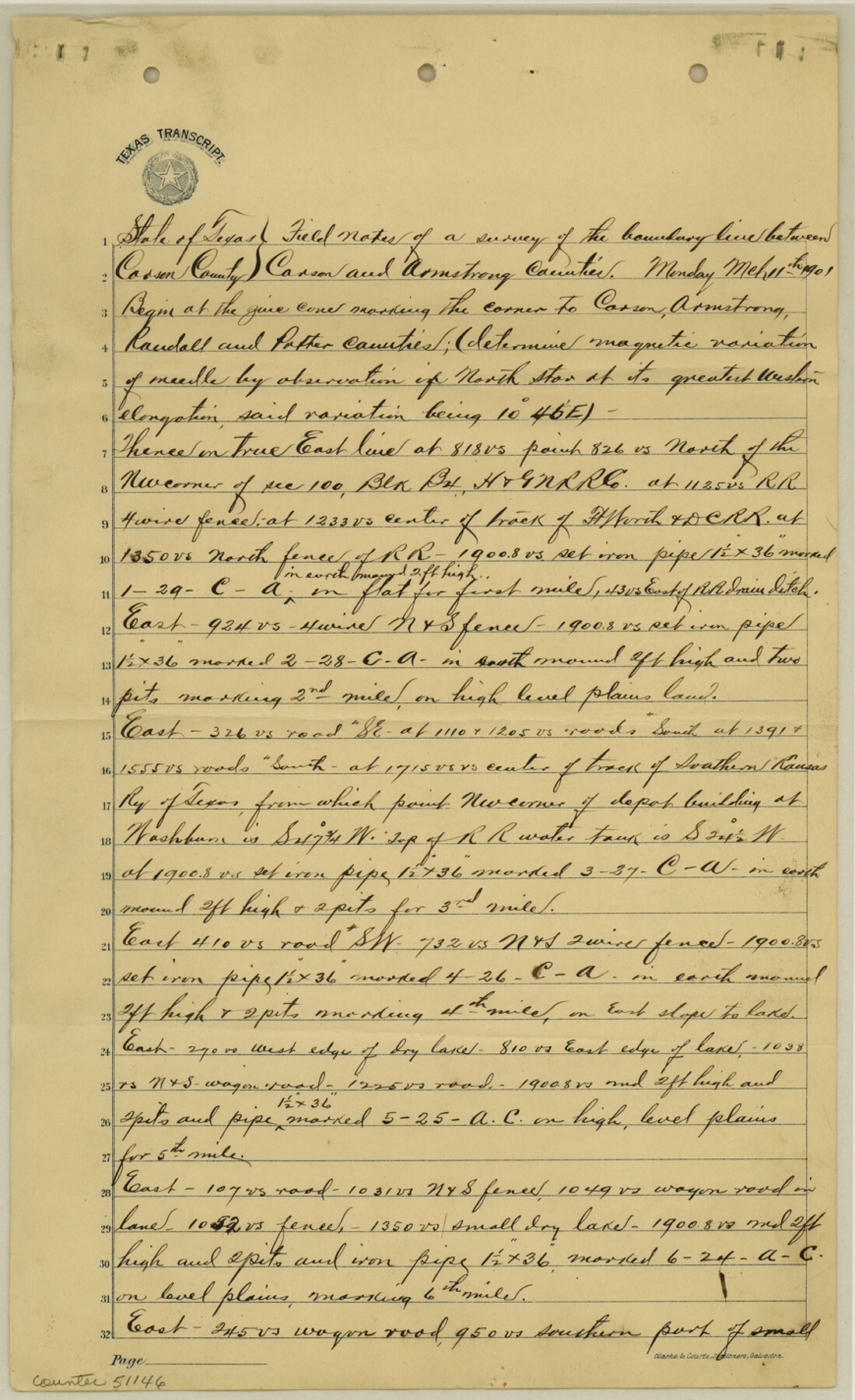
Carson County Boundary File 5c
Fieldnotes of the Bdry. line between Carson and Armstrong Counties
-
Map/Doc
51146
-
Collection
General Map Collection
-
Counties
Carson
-
Subjects
County Boundaries
-
Height x Width
14.2 x 8.7 inches
36.1 x 22.1 cm
Part of: General Map Collection
Travis County Rolled Sketch 30

Print $20.00
- Digital $50.00
Travis County Rolled Sketch 30
1943
Size 26.5 x 25.6 inches
Map/Doc 8032
Montgomery County Working Sketch 58

Print $40.00
- Digital $50.00
Montgomery County Working Sketch 58
1962
Size 39.1 x 51.0 inches
Map/Doc 71165


Goliad County Working Sketch 7

Print $20.00
- Digital $50.00
Goliad County Working Sketch 7
1937
Size 35.0 x 32.9 inches
Map/Doc 63197
Brazoria County Rolled Sketch 41

Print $20.00
- Digital $50.00
Brazoria County Rolled Sketch 41
Size 30.3 x 21.3 inches
Map/Doc 5176
Pecos County Sketch File 70

Print $20.00
- Digital $50.00
Pecos County Sketch File 70
1939
Size 21.3 x 20.7 inches
Map/Doc 12181
Calhoun County Rolled Sketch 35

Print $20.00
- Digital $50.00
Calhoun County Rolled Sketch 35
1929
Size 36.5 x 26.6 inches
Map/Doc 5511
Chambers County Sketch File 31

Print $40.00
- Digital $50.00
Chambers County Sketch File 31
1856
Size 12.4 x 15.2 inches
Map/Doc 17614
Flight Mission No. DIX-3P, Frame 165, Aransas County

Print $20.00
- Digital $50.00
Flight Mission No. DIX-3P, Frame 165, Aransas County
1956
Size 17.8 x 18.4 inches
Map/Doc 83771
Bandera County Sketch File 30

Print $40.00
- Digital $50.00
Bandera County Sketch File 30
Size 16.8 x 13.4 inches
Map/Doc 14021
Starr County Rolled Sketch 22

Print $20.00
- Digital $50.00
Starr County Rolled Sketch 22
1919
Size 37.3 x 22.3 inches
Map/Doc 7806
You may also like
Reagan County Sketch File 33

Print $4.00
- Digital $50.00
Reagan County Sketch File 33
1948
Size 8.9 x 14.4 inches
Map/Doc 35028
Houston County Sketch File 2

Print $4.00
- Digital $50.00
Houston County Sketch File 2
1857
Size 12.6 x 7.9 inches
Map/Doc 26746
Ownership Map of Val Verde County

Print $20.00
- Digital $50.00
Ownership Map of Val Verde County
1927
Size 32.7 x 36.9 inches
Map/Doc 92847
Galveston County Sketch File 66

Print $116.00
- Digital $50.00
Galveston County Sketch File 66
Size 5.0 x 10.0 inches
Map/Doc 23751
The Mexican Municipality of Matagorda. December 28, 1834

Print $20.00
The Mexican Municipality of Matagorda. December 28, 1834
2020
Size 15.9 x 21.7 inches
Map/Doc 96026
Atlas Pintoresco e Historico de los Estados Unidos Mexicanos

Atlas Pintoresco e Historico de los Estados Unidos Mexicanos
Map/Doc 96796
The Newest Land Of Promise - The Pecos Valley in Texas

Print $20.00
- Digital $50.00
The Newest Land Of Promise - The Pecos Valley in Texas
1900
Size 17.8 x 22.9 inches
Map/Doc 97038
El Paso County Boundary File 20

Print $9.00
- Digital $50.00
El Paso County Boundary File 20
Size 13.2 x 8.3 inches
Map/Doc 53210
Map of Liberty County

Print $40.00
- Digital $50.00
Map of Liberty County
1903
Size 54.9 x 53.6 inches
Map/Doc 16878
Glasscock County Sketch File 13

Print $20.00
- Digital $50.00
Glasscock County Sketch File 13
1935
Size 18.8 x 17.8 inches
Map/Doc 11562
Presidio County Rolled Sketch 41

Print $20.00
- Digital $50.00
Presidio County Rolled Sketch 41
1907
Size 20.7 x 25.0 inches
Map/Doc 7338
Flight Mission No. DQO-8K, Frame 21, Galveston County

Print $20.00
- Digital $50.00
Flight Mission No. DQO-8K, Frame 21, Galveston County
1952
Size 18.6 x 22.3 inches
Map/Doc 85144