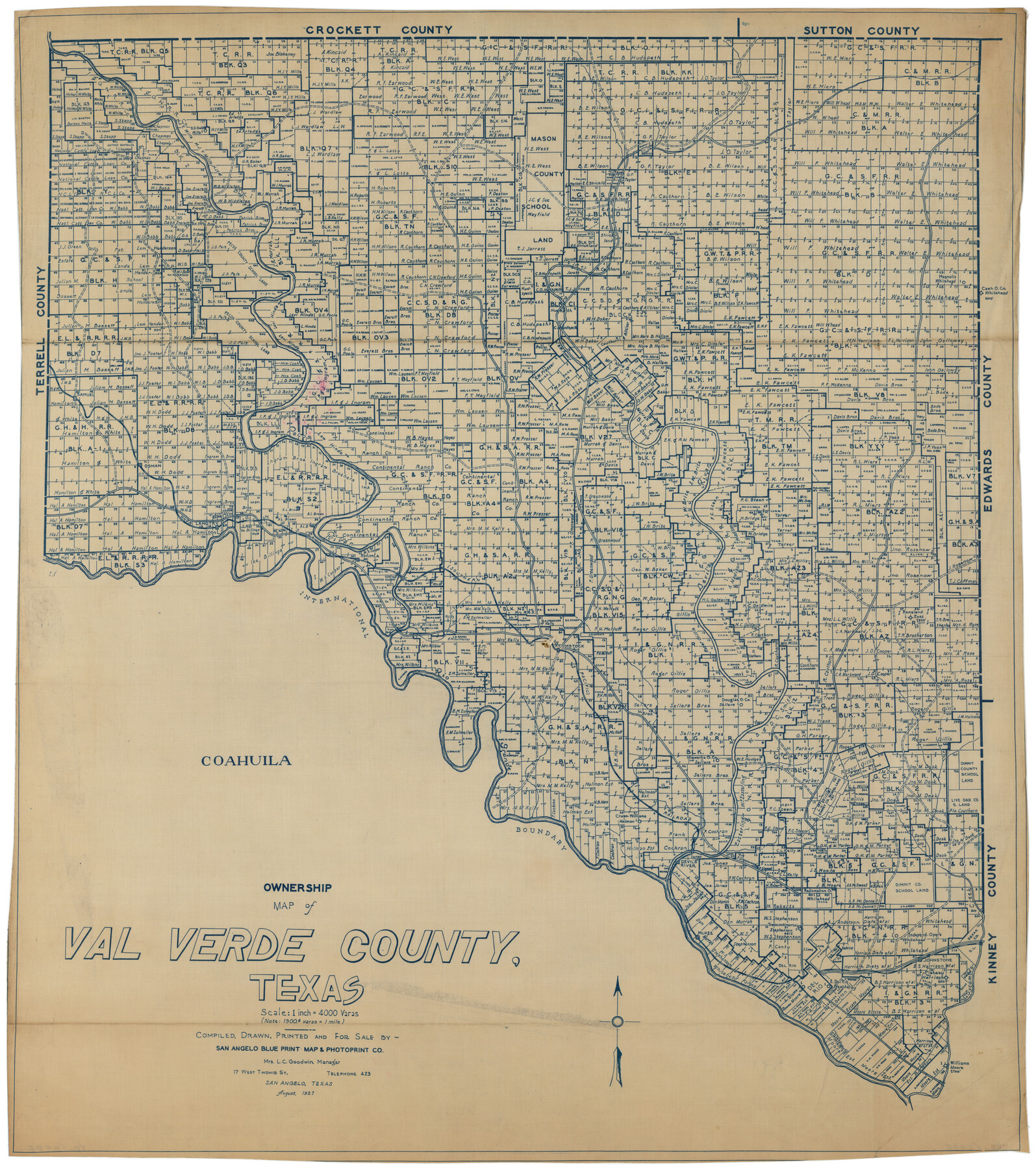
Ownership Map of Val Verde County
-
Map/Doc
92847
-
Collection
Twichell Survey Records
-
Object Dates
8/1927 (Creation Date)
-
People and Organizations
San Angelo Blueprint Map & Photoprint Co. (Draftsman)
San Angelo Blue Print Map & Photoprint Co. (Compiler)
-
Counties
Val Verde
-
Subjects
County
-
Height x Width
32.7 x 36.9 inches
83.1 x 93.7 cm
Part of: Twichell Survey Records
[Yoakum and Gaines County Line Along Block D in Yoakum and Blocks A6, AX, C35 and C34 in Gaines]
![89691, [Yoakum and Gaines County Line Along Block D in Yoakum and Blocks A6, AX, C35 and C34 in Gaines], Twichell Survey Records](https://historictexasmaps.com/wmedia_w700/maps/89691-1.tif.jpg)
Print $40.00
- Digital $50.00
[Yoakum and Gaines County Line Along Block D in Yoakum and Blocks A6, AX, C35 and C34 in Gaines]
1924
Size 54.9 x 12.3 inches
Map/Doc 89691
[H. & T. C. Blocks 47 1/2 and 48, Capitol Lands]
![90639, [H. & T. C. Blocks 47 1/2 and 48, Capitol Lands], Twichell Survey Records](https://historictexasmaps.com/wmedia_w700/maps/90639-1.tif.jpg)
Print $20.00
- Digital $50.00
[H. & T. C. Blocks 47 1/2 and 48, Capitol Lands]
Size 19.9 x 24.8 inches
Map/Doc 90639
[Blocks 44, 6T, 2G, and Vicinity]
![91519, [Blocks 44, 6T, 2G, and Vicinity], Twichell Survey Records](https://historictexasmaps.com/wmedia_w700/maps/91519-1.tif.jpg)
Print $20.00
- Digital $50.00
[Blocks 44, 6T, 2G, and Vicinity]
Size 24.5 x 16.9 inches
Map/Doc 91519
[S.E. corner of Sec. 48, Blk. 35 T5N to N.E. corner of Sec. 1, Blk. 35 T5N]
![89826, [S.E. corner of Sec. 48, Blk. 35 T5N to N.E. corner of Sec. 1, Blk. 35 T5N], Twichell Survey Records](https://historictexasmaps.com/wmedia_w700/maps/89826-1.tif.jpg)
Print $40.00
- Digital $50.00
[S.E. corner of Sec. 48, Blk. 35 T5N to N.E. corner of Sec. 1, Blk. 35 T5N]
1907
Size 7.2 x 72.9 inches
Map/Doc 89826
Sketch of Block A7, Hartley County, Texas

Print $20.00
- Digital $50.00
Sketch of Block A7, Hartley County, Texas
1905
Size 10.2 x 22.1 inches
Map/Doc 90756
[Morris County School Land Leagues and vicinity]
![90336, [Morris County School Land Leagues and vicinity], Twichell Survey Records](https://historictexasmaps.com/wmedia_w700/maps/90336-1.tif.jpg)
Print $20.00
- Digital $50.00
[Morris County School Land Leagues and vicinity]
Size 14.3 x 12.7 inches
Map/Doc 90336
Working Sketch Crosby, Garza, Lynn, and Lubbock Counties

Print $20.00
- Digital $50.00
Working Sketch Crosby, Garza, Lynn, and Lubbock Counties
1904
Size 34.3 x 36.4 inches
Map/Doc 92695
[Township 3 North, Blocks 33 and 34, T. & P. RR. Company; Township 4 North, Block 33, T. & P. RR. Company]
![92564, [Township 3 North, Blocks 33 and 34, T. & P. RR. Company; Township 4 North, Block 33, T. & P. RR. Company], Twichell Survey Records](https://historictexasmaps.com/wmedia_w700/maps/92564-1.tif.jpg)
Print $20.00
- Digital $50.00
[Township 3 North, Blocks 33 and 34, T. & P. RR. Company; Township 4 North, Block 33, T. & P. RR. Company]
1911
Size 18.6 x 24.8 inches
Map/Doc 92564
[Sketch to show the positions of surveys 1-18 made by G. R. Jowell with reference to Capitol Leagues]
![90539, [Sketch to show the positions of surveys 1-18 made by G. R. Jowell with reference to Capitol Leagues], Twichell Survey Records](https://historictexasmaps.com/wmedia_w700/maps/90539-1.tif.jpg)
Print $20.00
- Digital $50.00
[Sketch to show the positions of surveys 1-18 made by G. R. Jowell with reference to Capitol Leagues]
1905
Size 14.7 x 14.6 inches
Map/Doc 90539
[North line of Sherman, Hansford, Ochiltree and Lipscomb Counties]
![93189, [North line of Sherman, Hansford, Ochiltree and Lipscomb Counties], Twichell Survey Records](https://historictexasmaps.com/wmedia_w700/maps/93189-1.tif.jpg)
Print $40.00
- Digital $50.00
[North line of Sherman, Hansford, Ochiltree and Lipscomb Counties]
Size 127.0 x 14.3 inches
Map/Doc 93189
[Sketch of Leagues 458, 459, 474, 475, 480 and 481]
![91547, [Sketch of Leagues 458, 459, 474, 475, 480 and 481], Twichell Survey Records](https://historictexasmaps.com/wmedia_w700/maps/91547-1.tif.jpg)
Print $2.00
- Digital $50.00
[Sketch of Leagues 458, 459, 474, 475, 480 and 481]
Size 5.2 x 8.3 inches
Map/Doc 91547
Lamb-Bailey County Line

Print $40.00
- Digital $50.00
Lamb-Bailey County Line
Size 15.1 x 52.6 inches
Map/Doc 89636
You may also like
Block I, Dickens County Compiled by W.D. Twichell as directed by Cowan & Burney Upon G.M. Williams' Measurements

Print $20.00
- Digital $50.00
Block I, Dickens County Compiled by W.D. Twichell as directed by Cowan & Burney Upon G.M. Williams' Measurements
1916
Size 41.5 x 41.7 inches
Map/Doc 89770
San Patricio County NRC Article 33.136 Location Key Sheet

Print $20.00
- Digital $50.00
San Patricio County NRC Article 33.136 Location Key Sheet
1975
Size 27.0 x 23.0 inches
Map/Doc 87914
Map Showing Survey of Navasota River Bed in Limestone County Texas Located North of Houston and Texas Central Railroad Bridge

Print $20.00
- Digital $50.00
Map Showing Survey of Navasota River Bed in Limestone County Texas Located North of Houston and Texas Central Railroad Bridge
1921
Size 45.8 x 38.5 inches
Map/Doc 65348
Runnels County Working Sketch 5

Print $20.00
- Digital $50.00
Runnels County Working Sketch 5
1907
Size 17.2 x 16.1 inches
Map/Doc 63601
Rio Grande, North Extension McAllen Sheet

Print $20.00
- Digital $50.00
Rio Grande, North Extension McAllen Sheet
1937
Size 18.5 x 42.1 inches
Map/Doc 65108
Chocolate Bay, West Portion of West Bay and Vicinity, Brazoria and Galveston Counties, showing Subdivision for Mineral Development

Print $40.00
- Digital $50.00
Chocolate Bay, West Portion of West Bay and Vicinity, Brazoria and Galveston Counties, showing Subdivision for Mineral Development
1948
Size 40.7 x 53.9 inches
Map/Doc 1907
Flight Mission No. DQN-6K, Frame 14, Calhoun County

Print $20.00
- Digital $50.00
Flight Mission No. DQN-6K, Frame 14, Calhoun County
1953
Size 18.4 x 22.2 inches
Map/Doc 84436
Leon County Working Sketch 15

Print $20.00
- Digital $50.00
Leon County Working Sketch 15
1958
Size 27.3 x 26.7 inches
Map/Doc 70414
Galveston County NRC Article 33.136 Sketch 80

Print $24.00
- Digital $50.00
Galveston County NRC Article 33.136 Sketch 80
2014
Size 36.0 x 24.0 inches
Map/Doc 94987
The Principal Transportation Lines extending west from Boston, New York, Philadelphia, and Baltimore

Print $20.00
- Digital $50.00
The Principal Transportation Lines extending west from Boston, New York, Philadelphia, and Baltimore
1881
Size 17.1 x 24.4 inches
Map/Doc 95908
Tyler County Rolled Sketch 12

Print $20.00
- Digital $50.00
Tyler County Rolled Sketch 12
1988
Size 25.2 x 19.3 inches
Map/Doc 8060
Northern Part of Laguna Madre

Print $20.00
- Digital $50.00
Northern Part of Laguna Madre
1968
Size 44.4 x 34.5 inches
Map/Doc 73528