Oldham County Boundary File 1d
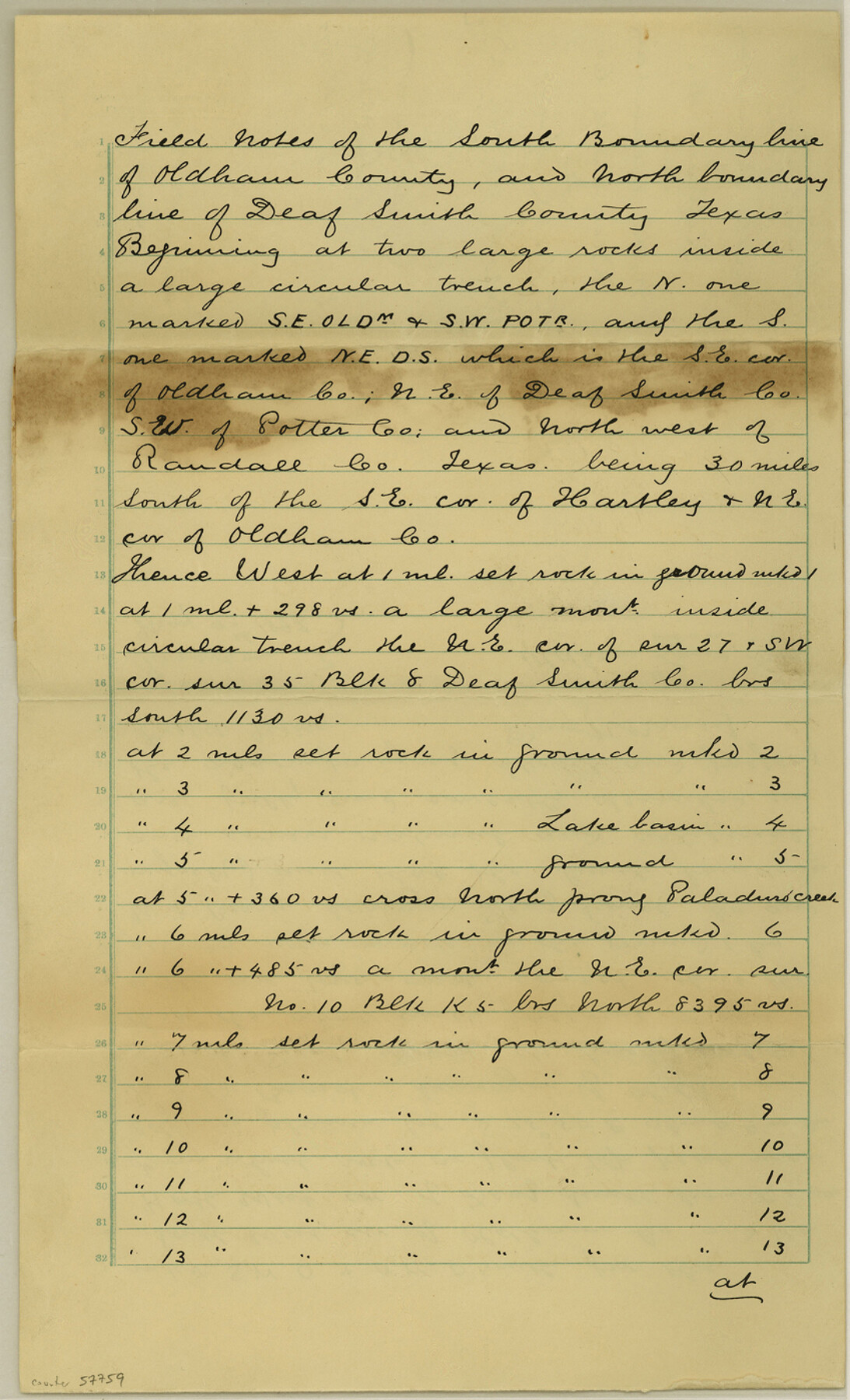
Sketch showing the south boundary line of Oldham County Texas accompanying field notes
-
Map/Doc
57759
-
Collection
General Map Collection
-
Counties
Oldham
-
Subjects
County Boundaries
-
Height x Width
14.0 x 8.5 inches
35.6 x 21.6 cm
Part of: General Map Collection
Flight Mission No. BQR-14K, Frame 37, Brazoria County

Print $20.00
- Digital $50.00
Flight Mission No. BQR-14K, Frame 37, Brazoria County
1952
Size 18.6 x 22.2 inches
Map/Doc 84094
Starr County Rolled Sketch 19

Print $20.00
- Digital $50.00
Starr County Rolled Sketch 19
1920
Size 20.8 x 24.9 inches
Map/Doc 7803
[Surveys along San Cristoval Creek]
![300, [Surveys along San Cristoval Creek], General Map Collection](https://historictexasmaps.com/wmedia_w700/maps/300.tif.jpg)
Print $2.00
- Digital $50.00
[Surveys along San Cristoval Creek]
1842
Size 9.0 x 9.3 inches
Map/Doc 300
Brazoria County Rolled Sketch 49

Print $20.00
- Digital $50.00
Brazoria County Rolled Sketch 49
1948
Size 24.1 x 36.5 inches
Map/Doc 5186
Culberson County Working Sketch 40

Print $40.00
- Digital $50.00
Culberson County Working Sketch 40
1966
Size 35.5 x 60.9 inches
Map/Doc 68493
Hockley County

Print $20.00
- Digital $50.00
Hockley County
1954
Size 44.2 x 39.7 inches
Map/Doc 95531
Fayette County Working Sketch 5

Print $20.00
- Digital $50.00
Fayette County Working Sketch 5
1981
Size 16.2 x 14.6 inches
Map/Doc 69169
Hardin County Sketch File 32a

Print $11.00
- Digital $50.00
Hardin County Sketch File 32a
Size 8.4 x 9.8 inches
Map/Doc 25167
Throckmorton County Sketch File 6a

Print $20.00
- Digital $50.00
Throckmorton County Sketch File 6a
1897
Size 14.5 x 12.7 inches
Map/Doc 38089
Aransas County Working Sketch 16

Print $40.00
- Digital $50.00
Aransas County Working Sketch 16
1965
Size 55.3 x 43.1 inches
Map/Doc 67183
Liberty County Working Sketch 3

Print $20.00
- Digital $50.00
Liberty County Working Sketch 3
1891
Size 16.2 x 13.2 inches
Map/Doc 70462
Glasscock County Sketch File 14

Print $8.00
- Digital $50.00
Glasscock County Sketch File 14
1935
Size 11.3 x 8.6 inches
Map/Doc 24178
You may also like
Bell County Working Sketch 5

Print $20.00
- Digital $50.00
Bell County Working Sketch 5
1942
Size 26.9 x 21.0 inches
Map/Doc 67345
Jim Hogg County Sketch File 6

Print $20.00
- Digital $50.00
Jim Hogg County Sketch File 6
1939
Size 17.9 x 19.6 inches
Map/Doc 11886
Subdivision for R.N. Graham

Print $3.00
- Digital $50.00
Subdivision for R.N. Graham
1913
Size 15.2 x 10.4 inches
Map/Doc 83430
Galveston to Rio Grande

Print $20.00
- Digital $50.00
Galveston to Rio Grande
1967
Size 44.4 x 37.0 inches
Map/Doc 69955
Travis County Boundary File 20

Print $6.00
- Digital $50.00
Travis County Boundary File 20
Size 14.4 x 9.2 inches
Map/Doc 59454
Yoakum County Sketch File 5

Print $10.00
- Digital $50.00
Yoakum County Sketch File 5
1899
Size 14.3 x 9.0 inches
Map/Doc 40733
Brazoria County Rolled Sketch AM

Print $20.00
- Digital $50.00
Brazoria County Rolled Sketch AM
1935
Size 27.1 x 43.2 inches
Map/Doc 5189
Wilbarger County Sketch File 23

Print $4.00
- Digital $50.00
Wilbarger County Sketch File 23
1887
Size 14.2 x 8.8 inches
Map/Doc 40223
Cherokee County Sketch File 19

Print $4.00
- Digital $50.00
Cherokee County Sketch File 19
1876
Size 8.2 x 8.4 inches
Map/Doc 18161
Nueces County Aerial Photograph Index Sheet 23

Print $20.00
- Digital $50.00
Nueces County Aerial Photograph Index Sheet 23
1938
Size 24.4 x 20.3 inches
Map/Doc 86844
Map Prepared from Data by Original Field Book by W.D. Twichell

Print $40.00
- Digital $50.00
Map Prepared from Data by Original Field Book by W.D. Twichell
Size 64.0 x 40.0 inches
Map/Doc 89733
Flight Mission No. DCL-6C, Frame 8, Kenedy County

Print $20.00
- Digital $50.00
Flight Mission No. DCL-6C, Frame 8, Kenedy County
1943
Size 18.5 x 22.5 inches
Map/Doc 85868