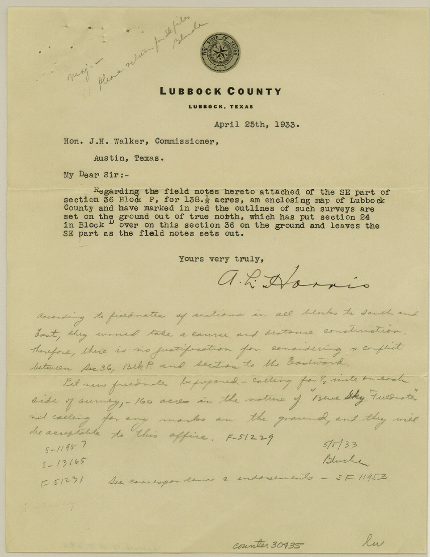
Lubbock County Sketch File 12
[Map showing location of part of survey 36, Block P]
-
Map/Doc
30435
-
Collection
General Map Collection
-
Object Dates
4/25/1933 (Creation Date)
7/20/1933 (File Date)
4/25/1933 (Correspondence Date)
1927 (Copyright Date)
-
People and Organizations
A.L. Harris (Surveyor/Engineer)
-
Counties
Lubbock
-
Subjects
Surveying Sketch File
-
Height x Width
11.1 x 8.6 inches
28.2 x 21.8 cm
-
Medium
multi-page, multi-format
-
Features
Abernathy
Estacado
Monroe
Santa Fe Railroad
Caldwell
New Ward
Ward
Liberty
Olforth
Foster
Posey
Nomad
Woodrow
Part of: General Map Collection
Franklin County Working Sketch Graphic Index

Print $20.00
- Digital $50.00
Franklin County Working Sketch Graphic Index
1942
Size 40.3 x 16.2 inches
Map/Doc 76546
Cameron County Boundary File 4

Print $42.00
- Digital $50.00
Cameron County Boundary File 4
Size 10.4 x 8.2 inches
Map/Doc 51110
Travis County Rolled Sketch 13

Print $20.00
- Digital $50.00
Travis County Rolled Sketch 13
Size 28.0 x 20.4 inches
Map/Doc 8016
Collin County

Print $20.00
- Digital $50.00
Collin County
1975
Size 42.7 x 39.8 inches
Map/Doc 95459
Flight Mission No. DCL-3C, Frame 156, Kenedy County

Print $20.00
- Digital $50.00
Flight Mission No. DCL-3C, Frame 156, Kenedy County
1943
Size 18.5 x 22.3 inches
Map/Doc 85804
Map of the Houston and G. N. R.R. and lands adjacent, from Troupe to the Texas Pacific R.R.

Print $40.00
- Digital $50.00
Map of the Houston and G. N. R.R. and lands adjacent, from Troupe to the Texas Pacific R.R.
Size 21.2 x 92.0 inches
Map/Doc 64627
Controlled Mosaic by Jack Amman Photogrammetric Engineers, Inc - Sheet 28

Print $20.00
- Digital $50.00
Controlled Mosaic by Jack Amman Photogrammetric Engineers, Inc - Sheet 28
1954
Size 21.1 x 24.1 inches
Map/Doc 83480
Right of Way and Track Map, the Missouri, Kansas and Texas Ry. of Texas - Henrietta Division

Print $20.00
- Digital $50.00
Right of Way and Track Map, the Missouri, Kansas and Texas Ry. of Texas - Henrietta Division
1918
Size 11.9 x 26.8 inches
Map/Doc 64753
Culberson County Sketch File 5

Print $4.00
- Digital $50.00
Culberson County Sketch File 5
Size 9.4 x 8.2 inches
Map/Doc 20136
Uvalde County

Print $20.00
- Digital $50.00
Uvalde County
1915
Size 42.9 x 46.2 inches
Map/Doc 63091
Jackson County Sketch File A2 (1)

Print $20.00
- Digital $50.00
Jackson County Sketch File A2 (1)
1899
Size 18.2 x 22.5 inches
Map/Doc 11848
Hutchinson County Sketch File 24

Print $24.00
- Digital $50.00
Hutchinson County Sketch File 24
1922
Size 7.5 x 8.7 inches
Map/Doc 27256
You may also like
Liberty County Working Sketch 17

Print $20.00
- Digital $50.00
Liberty County Working Sketch 17
1934
Size 34.5 x 24.0 inches
Map/Doc 70476
Lubbock County Rolled Sketch 6

Print $20.00
- Digital $50.00
Lubbock County Rolled Sketch 6
1914
Size 26.0 x 24.1 inches
Map/Doc 6642
General Highway Map, Jim Hogg County, Texas

Print $20.00
General Highway Map, Jim Hogg County, Texas
1961
Size 24.6 x 18.2 inches
Map/Doc 79541
Plan C, Part 1st Shewing that portion of the boundary between Texas and the United States, included between the intersection of the 32nd degree of Latitude with western bank of Sabine River and the 36th mile mound

Print $20.00
- Digital $50.00
Plan C, Part 1st Shewing that portion of the boundary between Texas and the United States, included between the intersection of the 32nd degree of Latitude with western bank of Sabine River and the 36th mile mound
1842
Size 19.4 x 27.7 inches
Map/Doc 65412
Newton County Sketch File 4c

Print $4.00
- Digital $50.00
Newton County Sketch File 4c
Size 7.4 x 8.2 inches
Map/Doc 32366
Waller County Working Sketch 7

Print $20.00
- Digital $50.00
Waller County Working Sketch 7
2000
Size 34.6 x 41.5 inches
Map/Doc 72306
Kinney County

Print $40.00
- Digital $50.00
Kinney County
1909
Size 49.8 x 44.2 inches
Map/Doc 66893
General Highway Map Lynn County

Print $20.00
- Digital $50.00
General Highway Map Lynn County
1949
Size 25.8 x 18.8 inches
Map/Doc 92901
Right of Way and Track Map, the Missouri, Kansas & Texas Ry. Of Texas operated by the Missouri, Kansas & Texas Ry. Of Texas, Houston Division

Print $40.00
- Digital $50.00
Right of Way and Track Map, the Missouri, Kansas & Texas Ry. Of Texas operated by the Missouri, Kansas & Texas Ry. Of Texas, Houston Division
1918
Size 25.6 x 64.4 inches
Map/Doc 64566

Outer Continental Shelf Leasing Maps (Texas Offshore Operations)

Print $20.00
- Digital $50.00
Outer Continental Shelf Leasing Maps (Texas Offshore Operations)
Size 21.0 x 15.2 inches
Map/Doc 75840
Gray County Sketch File A

Print $20.00
- Digital $50.00
Gray County Sketch File A
1889
Size 14.2 x 14.6 inches
Map/Doc 24456