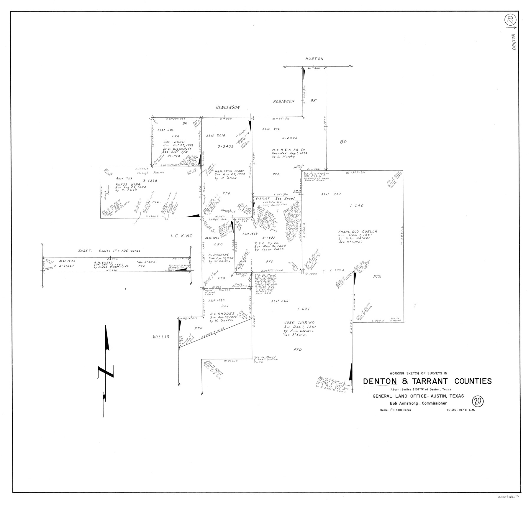
Denton County Working Sketch 20
-
Map/Doc
68625
-
Collection
General Map Collection
-
Object Dates
10/20/1978 (Creation Date)
-
People and Organizations
Elbert Menzel (Draftsman)
-
Counties
Denton Tarrant
-
Subjects
Surveying Working Sketch
-
Height x Width
31.6 x 33.2 inches
80.3 x 84.3 cm
-
Scale
1" = 300 varas
Part of: General Map Collection
Upshur County Working Sketch 14

Print $20.00
- Digital $50.00
Upshur County Working Sketch 14
1993
Size 23.1 x 37.1 inches
Map/Doc 69571
Williamson County Working Sketch 3

Print $20.00
- Digital $50.00
Williamson County Working Sketch 3
1915
Size 17.9 x 20.2 inches
Map/Doc 72563
Kerr County Sketch File 6b

Print $4.00
- Digital $50.00
Kerr County Sketch File 6b
1880
Size 8.5 x 13.6 inches
Map/Doc 28867
Kent County Sketch File 9

Print $8.00
- Digital $50.00
Kent County Sketch File 9
Size 10.3 x 8.1 inches
Map/Doc 28832
Uvalde County Sketch File 15

Print $6.00
- Digital $50.00
Uvalde County Sketch File 15
1849
Size 8.8 x 11.5 inches
Map/Doc 38985
Soil Map - Reconnoissance Survey - South Texas Sheet

Print $20.00
- Digital $50.00
Soil Map - Reconnoissance Survey - South Texas Sheet
1909
Size 28.6 x 37.8 inches
Map/Doc 97267
Somervell County Working Sketch 7

Print $20.00
- Digital $50.00
Somervell County Working Sketch 7
2008
Size 27.9 x 34.2 inches
Map/Doc 88889
Mitchell County

Print $20.00
- Digital $50.00
Mitchell County
1922
Size 43.4 x 38.2 inches
Map/Doc 66936
Bandera County Working Sketch 35

Print $20.00
- Digital $50.00
Bandera County Working Sketch 35
1965
Size 20.8 x 21.6 inches
Map/Doc 67631
Childress County Working Sketch 5

Print $20.00
- Digital $50.00
Childress County Working Sketch 5
1948
Size 19.6 x 23.5 inches
Map/Doc 68021
Rio Grande Rectification Project, El Paso and Juarez Valley

Print $20.00
- Digital $50.00
Rio Grande Rectification Project, El Paso and Juarez Valley
1935
Size 10.7 x 29.7 inches
Map/Doc 60870
Flight Mission No. BRA-16M, Frame 61, Jefferson County

Print $20.00
- Digital $50.00
Flight Mission No. BRA-16M, Frame 61, Jefferson County
1953
Size 18.6 x 22.2 inches
Map/Doc 85678
You may also like
Parkland Place, An Addition to Muleshoe

Print $20.00
- Digital $50.00
Parkland Place, An Addition to Muleshoe
1955
Size 39.2 x 30.3 inches
Map/Doc 92531
Blanco County Sketch File 37

Print $4.00
- Digital $50.00
Blanco County Sketch File 37
Size 8.7 x 14.1 inches
Map/Doc 14646
Val Verde County Sketch File 2

Print $8.00
- Digital $50.00
Val Verde County Sketch File 2
1885
Size 12.8 x 8.0 inches
Map/Doc 39169
[Plat of the Town of Lockhart]
![82534, [Plat of the Town of Lockhart], General Map Collection](https://historictexasmaps.com/wmedia_w700/maps/82534-1.tif.jpg)
Print $20.00
- Digital $50.00
[Plat of the Town of Lockhart]
Size 19.5 x 25.0 inches
Map/Doc 82534
Matagorda County Working Sketch 29

Print $20.00
- Digital $50.00
Matagorda County Working Sketch 29
1981
Size 35.6 x 34.0 inches
Map/Doc 70887
DeWitt County Boundary File 25 1/2

Print $34.00
- Digital $50.00
DeWitt County Boundary File 25 1/2
Size 8.5 x 4.0 inches
Map/Doc 52522
Hays County Working Sketch 1

Print $20.00
- Digital $50.00
Hays County Working Sketch 1
1915
Size 20.0 x 17.3 inches
Map/Doc 66075
Fannin County Boundary File 7

Print $42.00
- Digital $50.00
Fannin County Boundary File 7
Size 5.3 x 31.1 inches
Map/Doc 53313
Flight Mission No. CRK-5P, Frame 154, Refugio County

Print $20.00
- Digital $50.00
Flight Mission No. CRK-5P, Frame 154, Refugio County
1956
Size 18.6 x 22.5 inches
Map/Doc 86935
Crane County Working Sketch 23

Print $20.00
- Digital $50.00
Crane County Working Sketch 23
1963
Size 25.8 x 23.2 inches
Map/Doc 68300

Bee County Boundary File 2

Print $10.00
- Digital $50.00
Bee County Boundary File 2
Size 8.8 x 6.8 inches
Map/Doc 50435