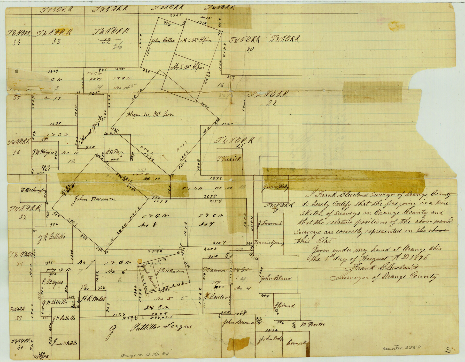
Orange County Sketch File 11
[Sketch of surveys in the central part of Orange County]
-
Map/Doc
33319
-
Collection
General Map Collection
-
Object Dates
8/1/1876 (Creation Date)
8/9/1876 (File Date)
-
People and Organizations
Frank Cleveland (Surveyor/Engineer)
-
Counties
Orange
-
Subjects
Surveying Sketch File
-
Height x Width
12.8 x 16.5 inches
32.5 x 41.9 cm
-
Medium
multi-page, multi-format
Part of: General Map Collection
Eastland County Working Sketch 15

Print $20.00
- Digital $50.00
Eastland County Working Sketch 15
1919
Size 21.2 x 23.0 inches
Map/Doc 68796
Throckmorton County Working Sketch 7

Print $20.00
- Digital $50.00
Throckmorton County Working Sketch 7
1956
Size 25.8 x 32.0 inches
Map/Doc 62116
Gaines County Working Sketch 36

Print $20.00
- Digital $50.00
Gaines County Working Sketch 36
Size 23.5 x 36.7 inches
Map/Doc 69336
Flight Mission No. CUG-1P, Frame 24, Kleberg County

Print $20.00
- Digital $50.00
Flight Mission No. CUG-1P, Frame 24, Kleberg County
1956
Size 18.5 x 22.1 inches
Map/Doc 86114
Flight Mission No. BRA-16M, Frame 103, Jefferson County

Print $20.00
- Digital $50.00
Flight Mission No. BRA-16M, Frame 103, Jefferson County
1953
Size 18.5 x 22.3 inches
Map/Doc 85715
Sterling County Sketch File 20

Print $12.00
- Digital $50.00
Sterling County Sketch File 20
1952
Size 11.2 x 8.7 inches
Map/Doc 37173
Dimmit County Rolled Sketch M

Print $20.00
- Digital $50.00
Dimmit County Rolled Sketch M
1936
Size 21.5 x 39.3 inches
Map/Doc 5727
Texas Official Travel Map

Digital $50.00
Texas Official Travel Map
Size 33.4 x 36.3 inches
Map/Doc 94425
Maps of the new and popular St. Louis and Texas Short Line composed of the St. Louis, Iron Mountain & Southern, Texas & Pacific and International & Great Northern Railways

Print $20.00
- Digital $50.00
Maps of the new and popular St. Louis and Texas Short Line composed of the St. Louis, Iron Mountain & Southern, Texas & Pacific and International & Great Northern Railways
1874
Size 19.0 x 32.0 inches
Map/Doc 93638
Harris County Sketch File 76

Print $20.00
- Digital $50.00
Harris County Sketch File 76
1948
Size 22.0 x 15.9 inches
Map/Doc 11665
Menard County

Print $20.00
- Digital $50.00
Menard County
1942
Size 40.1 x 43.7 inches
Map/Doc 66928
Aransas County Sketch File B

Print $4.00
- Digital $50.00
Aransas County Sketch File B
Size 6.9 x 11.4 inches
Map/Doc 13216
You may also like
Mills County Working Sketch 7

Print $20.00
- Digital $50.00
Mills County Working Sketch 7
1914
Size 12.8 x 13.0 inches
Map/Doc 71037
Cochran County

Print $20.00
- Digital $50.00
Cochran County
1946
Size 33.0 x 25.3 inches
Map/Doc 73107
Red River Co.

Print $20.00
- Digital $50.00
Red River Co.
1905
Size 46.7 x 39.6 inches
Map/Doc 66994
Nueces County Rolled Sketch 100

Print $20.00
- Digital $50.00
Nueces County Rolled Sketch 100
Size 21.3 x 32.7 inches
Map/Doc 10697
The Land Offices. No. 10, Bexar, December 22, 1836

Print $20.00
The Land Offices. No. 10, Bexar, December 22, 1836
2020
Size 19.2 x 16.2 inches
Map/Doc 96423
Rusk County Sketch File 17

Print $22.00
Rusk County Sketch File 17
1857
Size 12.7 x 15.7 inches
Map/Doc 35520
Padre Island, Register No. 1485a

Print $40.00
- Digital $50.00
Padre Island, Register No. 1485a
1881
Size 55.7 x 36.7 inches
Map/Doc 73609
Nacogdoches County Sketch File 16

Print $20.00
- Digital $50.00
Nacogdoches County Sketch File 16
1945
Size 24.6 x 18.5 inches
Map/Doc 42155
Henderson County Rolled Sketch 12

Print $20.00
- Digital $50.00
Henderson County Rolled Sketch 12
1980
Size 22.8 x 19.1 inches
Map/Doc 6204
Childress County Sketch File 24

Print $4.00
- Digital $50.00
Childress County Sketch File 24
1917
Size 12.9 x 8.6 inches
Map/Doc 18384
Nueces County Working Sketch 2

Print $20.00
- Digital $50.00
Nueces County Working Sketch 2
1950
Size 42.0 x 15.5 inches
Map/Doc 71304
Morris County Rolled Sketch 2A

Print $20.00
- Digital $50.00
Morris County Rolled Sketch 2A
Size 24.1 x 18.9 inches
Map/Doc 10261