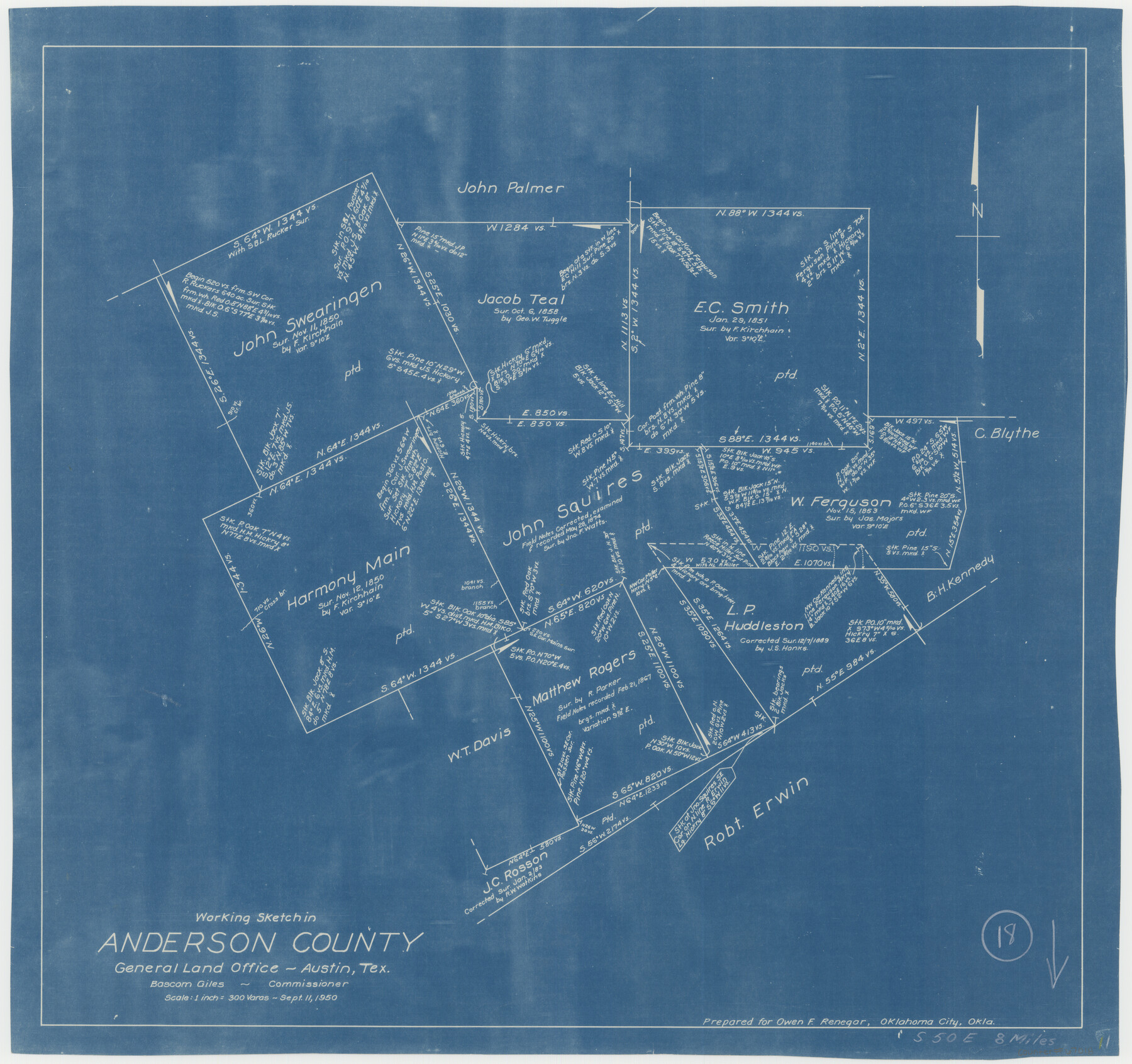
Anderson County Working Sketch 18
-
Map/Doc
67018
-
Collection
General Map Collection
-
Object Dates
9/11/1950 (Creation Date)
-
People and Organizations
Bascom Giles (GLO Commissioner)
-
Counties
Anderson
-
Subjects
Surveying Working Sketch
-
Height x Width
19.9 x 21.2 inches
50.6 x 53.9 cm
-
Scale
1" = 300 varas
-
Comments
Surveys located about eight miles South 50 degrees East of Palestine, Texas.
Part of: General Map Collection
Fort Bend County Working Sketch 8

Print $20.00
- Digital $50.00
Fort Bend County Working Sketch 8
1922
Size 24.9 x 17.6 inches
Map/Doc 69214
Briscoe County Sketch File A

Print $40.00
- Digital $50.00
Briscoe County Sketch File A
1894
Size 17.3 x 21.1 inches
Map/Doc 10997
Martin County Boundary File 1

Print $10.00
- Digital $50.00
Martin County Boundary File 1
Size 11.2 x 8.7 inches
Map/Doc 56757
Dawson County Working Sketch 15

Print $20.00
- Digital $50.00
Dawson County Working Sketch 15
1955
Size 28.2 x 24.8 inches
Map/Doc 68559
Dickens County Sketch File 37

Print $8.00
- Digital $50.00
Dickens County Sketch File 37
Size 10.3 x 8.3 inches
Map/Doc 21044
Leon County Rolled Sketch 7

Print $40.00
- Digital $50.00
Leon County Rolled Sketch 7
1954
Size 55.9 x 35.0 inches
Map/Doc 9428
Right of Way & Track Map, San Antonio & Aransas Pass Railway Co.

Print $40.00
- Digital $50.00
Right of Way & Track Map, San Antonio & Aransas Pass Railway Co.
1919
Size 25.0 x 56.7 inches
Map/Doc 64215
Wheeler County Sketch File 8

Print $6.00
- Digital $50.00
Wheeler County Sketch File 8
1935
Size 11.4 x 8.8 inches
Map/Doc 40005
Wilbarger County Working Sketch 17

Print $20.00
- Digital $50.00
Wilbarger County Working Sketch 17
1957
Size 7.5 x 18.4 inches
Map/Doc 72555
Red River, Water-Shed of Cypress Creek in Texas Drainage Area

Print $4.00
- Digital $50.00
Red River, Water-Shed of Cypress Creek in Texas Drainage Area
1925
Size 16.3 x 19.2 inches
Map/Doc 65057
Jeff Davis County Working Sketch 8

Print $20.00
- Digital $50.00
Jeff Davis County Working Sketch 8
1940
Size 45.4 x 42.9 inches
Map/Doc 66503
Crockett County Rolled Sketch 65

Print $20.00
- Digital $50.00
Crockett County Rolled Sketch 65
1948
Size 13.4 x 27.5 inches
Map/Doc 5608
You may also like
Anderson County Working Sketch 14

Print $20.00
- Digital $50.00
Anderson County Working Sketch 14
1933
Size 20.3 x 26.0 inches
Map/Doc 67014
Flight Mission No. CGI-3N, Frame 103, Cameron County

Print $20.00
- Digital $50.00
Flight Mission No. CGI-3N, Frame 103, Cameron County
1954
Size 18.4 x 22.2 inches
Map/Doc 84583
Kimble County Sketch File 14

Print $26.00
- Digital $50.00
Kimble County Sketch File 14
1886
Size 14.1 x 8.6 inches
Map/Doc 28939
Grayson County Working Sketch 18

Print $20.00
- Digital $50.00
Grayson County Working Sketch 18
1955
Size 22.8 x 21.1 inches
Map/Doc 63257
Sutton County Working Sketch 21

Print $20.00
- Digital $50.00
Sutton County Working Sketch 21
1978
Size 22.3 x 26.1 inches
Map/Doc 62364
Archer County Working Sketch 23

Print $40.00
- Digital $50.00
Archer County Working Sketch 23
1981
Size 31.7 x 48.3 inches
Map/Doc 67164
Map of Townsite of Swearingen, Cottle County, Texas

Print $20.00
- Digital $50.00
Map of Townsite of Swearingen, Cottle County, Texas
1919
Size 28.1 x 17.1 inches
Map/Doc 4463
Map of Matagorda Bay and County with the Adjacent Country

Print $20.00
- Digital $50.00
Map of Matagorda Bay and County with the Adjacent Country
1839
Size 33.4 x 42.6 inches
Map/Doc 2002
Aransas County Aerial Photograph Index Sheet 2

Print $20.00
- Digital $50.00
Aransas County Aerial Photograph Index Sheet 2
1957
Size 23.0 x 17.9 inches
Map/Doc 83660
Coke County Sketch File 17-18

Print $24.00
- Digital $50.00
Coke County Sketch File 17-18
1902
Size 16.6 x 14.2 inches
Map/Doc 11109
Cass County Working Sketch 21

Print $20.00
- Digital $50.00
Cass County Working Sketch 21
1961
Size 24.3 x 37.4 inches
Map/Doc 67924
[Sketch showing the Northwest part of Hale County and the Northeast part of Lamb County]
![93204, [Sketch showing the Northwest part of Hale County and the Northeast part of Lamb County], Twichell Survey Records](https://historictexasmaps.com/wmedia_w700/maps/93204-1.tif.jpg)
Print $40.00
- Digital $50.00
[Sketch showing the Northwest part of Hale County and the Northeast part of Lamb County]
Size 55.1 x 57.3 inches
Map/Doc 93204