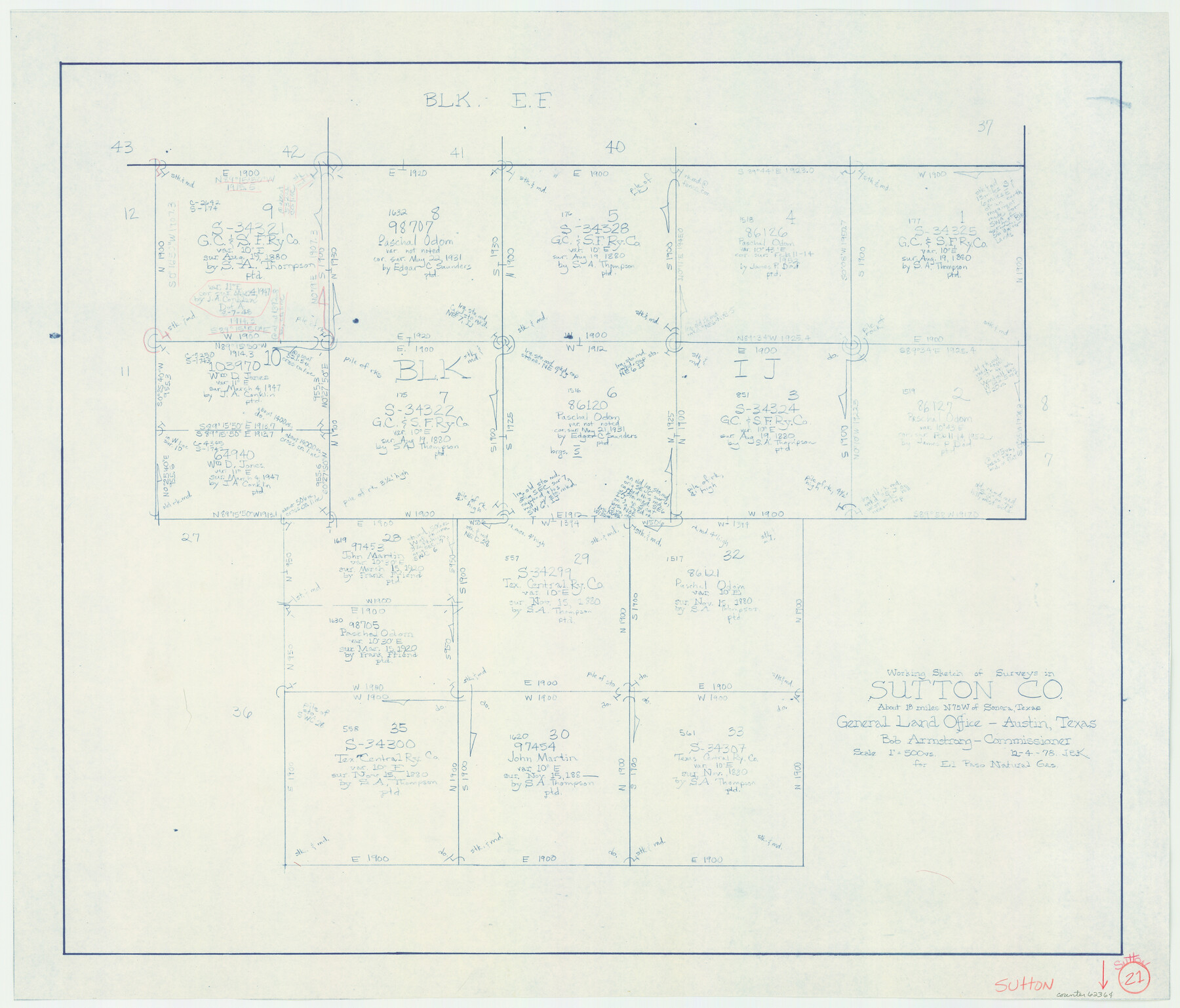
Sutton County Working Sketch 21
-
Map/Doc
62364
-
Collection
General Map Collection
-
Object Dates
12/4/1978 (Creation Date)
-
People and Organizations
Joan Kilpatrick (Draftsman)
-
Counties
Sutton
-
Subjects
Surveying Working Sketch
-
Height x Width
22.3 x 26.1 inches
56.6 x 66.3 cm
-
Scale
1" = 500 varas
Part of: General Map Collection
Medina County Working Sketch 10

Print $20.00
- Digital $50.00
Medina County Working Sketch 10
1960
Size 37.4 x 32.9 inches
Map/Doc 70925
Intracoastal Waterway in Texas - Corpus Christi to Point Isabel including Arroyo Colorado to Mo. Pac. R.R. Bridge Near Harlingen

Print $20.00
- Digital $50.00
Intracoastal Waterway in Texas - Corpus Christi to Point Isabel including Arroyo Colorado to Mo. Pac. R.R. Bridge Near Harlingen
1933
Size 28.0 x 41.0 inches
Map/Doc 61860
Tyler County Sketch File 1b

Print $8.00
- Digital $50.00
Tyler County Sketch File 1b
1900
Size 7.5 x 3.2 inches
Map/Doc 38611
Flight Mission No. DCL-4C, Frame 121, Kenedy County

Print $20.00
- Digital $50.00
Flight Mission No. DCL-4C, Frame 121, Kenedy County
1943
Size 18.6 x 22.3 inches
Map/Doc 85820
Big Lake Oil Field

Print $20.00
- Digital $50.00
Big Lake Oil Field
1924
Size 27.3 x 19.1 inches
Map/Doc 2420
Orange County Sketch File 17a

Print $4.00
- Digital $50.00
Orange County Sketch File 17a
Size 9.9 x 8.3 inches
Map/Doc 33342
Midland County Rolled Sketch 14

Print $40.00
- Digital $50.00
Midland County Rolled Sketch 14
Size 102.9 x 43.8 inches
Map/Doc 73579
Liberty County Sketch File 32

Print $8.00
- Digital $50.00
Liberty County Sketch File 32
1872
Size 10.3 x 8.2 inches
Map/Doc 29961
Red River County Working Sketch 39

Print $20.00
- Digital $50.00
Red River County Working Sketch 39
1967
Size 33.4 x 23.8 inches
Map/Doc 72022
Flight Mission No. BRE-1P, Frame 140, Nueces County

Print $20.00
- Digital $50.00
Flight Mission No. BRE-1P, Frame 140, Nueces County
1956
Size 18.8 x 22.7 inches
Map/Doc 86700
Flight Mission No. DCL-7C, Frame 113, Kenedy County

Print $20.00
- Digital $50.00
Flight Mission No. DCL-7C, Frame 113, Kenedy County
1943
Size 18.5 x 22.2 inches
Map/Doc 86078
Kleberg County Boundary File 2c

Print $40.00
- Digital $50.00
Kleberg County Boundary File 2c
Size 8.8 x 49.6 inches
Map/Doc 64979
You may also like
Hill County Boundary File 1a

Print $40.00
- Digital $50.00
Hill County Boundary File 1a
Size 18.4 x 23.3 inches
Map/Doc 54732
Flight Mission No. DQN-5K, Frame 38, Calhoun County

Print $20.00
- Digital $50.00
Flight Mission No. DQN-5K, Frame 38, Calhoun County
1953
Size 19.1 x 22.7 inches
Map/Doc 84386
Webb County Rolled Sketch 66

Print $20.00
- Digital $50.00
Webb County Rolled Sketch 66
1957
Size 31.9 x 21.8 inches
Map/Doc 8215
Henderson County Working Sketch 39

Print $20.00
- Digital $50.00
Henderson County Working Sketch 39
1982
Size 24.3 x 19.0 inches
Map/Doc 66172
[Sketch of part of G. & M. Block 5, G. & M. Block 4, Block M19 and Block 21W]
![93079, [Sketch of part of G. & M. Block 5, G. & M. Block 4, Block M19 and Block 21W], Twichell Survey Records](https://historictexasmaps.com/wmedia_w700/maps/93079-1.tif.jpg)
Print $20.00
- Digital $50.00
[Sketch of part of G. & M. Block 5, G. & M. Block 4, Block M19 and Block 21W]
Size 22.8 x 15.6 inches
Map/Doc 93079
Coryell County Working Sketch 17

Print $20.00
- Digital $50.00
Coryell County Working Sketch 17
1958
Size 35.4 x 35.0 inches
Map/Doc 68224
A new & correct map of Texas compiled from the most recent surveys & authorities to the year 1845

Print $20.00
- Digital $50.00
A new & correct map of Texas compiled from the most recent surveys & authorities to the year 1845
1845
Size 22.4 x 28.5 inches
Map/Doc 96973
Rusk County Sketch File 31

Print $10.00
Rusk County Sketch File 31
1949
Size 11.3 x 8.9 inches
Map/Doc 35563
Trinity River, South Extension Porters Bluff Sheet

Print $20.00
- Digital $50.00
Trinity River, South Extension Porters Bluff Sheet
1925
Size 16.3 x 24.4 inches
Map/Doc 69690
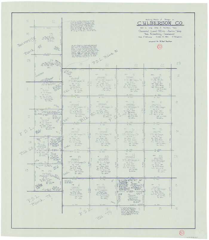
Culberson County Working Sketch 83
Print $20.00
- Digital $50.00
Culberson County Working Sketch 83
1980
Size 33.4 x 28.9 inches
Map/Doc 68537
[Texas Panhandle North Boundary Line]
![1714, [Texas Panhandle North Boundary Line], General Map Collection](https://historictexasmaps.com/wmedia_w700/maps/1714.tif.jpg)
Print $20.00
- Digital $50.00
[Texas Panhandle North Boundary Line]
1898
Size 43.6 x 11.4 inches
Map/Doc 1714
Matagorda Light to Aransas Pass

Print $20.00
- Digital $50.00
Matagorda Light to Aransas Pass
1935
Size 35.1 x 44.2 inches
Map/Doc 73393