Martin County Boundary File 1
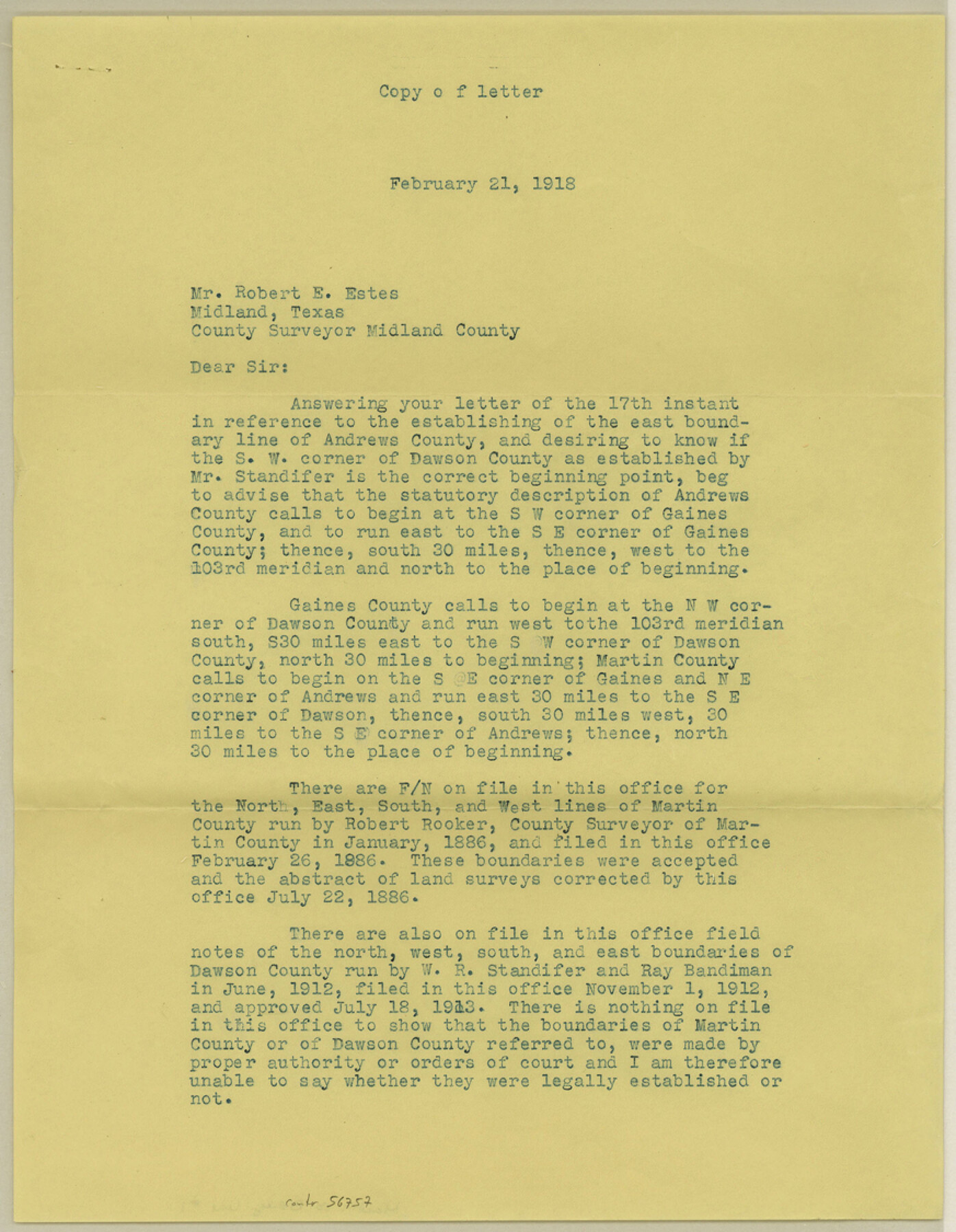
[Letter and Sketch of County Boundary lines]
-
Map/Doc
56757
-
Collection
General Map Collection
-
Counties
Martin
-
Subjects
County Boundaries
-
Height x Width
11.2 x 8.7 inches
28.5 x 22.1 cm
Part of: General Map Collection
Red River County Working Sketch 21

Print $20.00
- Digital $50.00
Red River County Working Sketch 21
1955
Size 33.2 x 18.5 inches
Map/Doc 72004
Carson County Sketch File 2

Print $20.00
- Digital $50.00
Carson County Sketch File 2
1888
Size 19.5 x 21.1 inches
Map/Doc 11054
Gillespie County Working Sketch Graphic Index

Print $20.00
- Digital $50.00
Gillespie County Working Sketch Graphic Index
1945
Size 38.0 x 47.4 inches
Map/Doc 76553
Map of Ramon Musquiz Survey, Meanders of Lavaca & Navidad Rivers, Menefee & Redfish Lakes

Print $20.00
- Digital $50.00
Map of Ramon Musquiz Survey, Meanders of Lavaca & Navidad Rivers, Menefee & Redfish Lakes
1934
Size 23.4 x 18.4 inches
Map/Doc 65455
Moore County Rolled Sketch 12

Print $20.00
- Digital $50.00
Moore County Rolled Sketch 12
1919
Size 24.9 x 22.7 inches
Map/Doc 6828
Clay County Working Sketch Graphic Index

Print $40.00
- Digital $50.00
Clay County Working Sketch Graphic Index
1971
Size 58.4 x 34.3 inches
Map/Doc 76494
Nueces County Rolled Sketch 27A

Print $40.00
- Digital $50.00
Nueces County Rolled Sketch 27A
1946
Size 12.4 x 121.3 inches
Map/Doc 9597
Calhoun County Rolled Sketch 12

Print $40.00
- Digital $50.00
Calhoun County Rolled Sketch 12
1940
Size 37.9 x 54.6 inches
Map/Doc 66845
Angelina County Sketch File 5a

Print $4.00
- Digital $50.00
Angelina County Sketch File 5a
1857
Size 8.6 x 7.7 inches
Map/Doc 12931
Martin County Rolled Sketch 10A

Print $20.00
- Digital $50.00
Martin County Rolled Sketch 10A
1994
Size 18.3 x 24.5 inches
Map/Doc 6671
Nueces County Rolled Sketch 68

Print $20.00
- Digital $50.00
Nueces County Rolled Sketch 68
1980
Size 19.9 x 25.4 inches
Map/Doc 6919
Cochran County Rolled Sketch 5

Print $20.00
- Digital $50.00
Cochran County Rolled Sketch 5
1949
Size 21.5 x 22.0 inches
Map/Doc 5502
You may also like
Carson County Boundary File 1

Print $8.00
- Digital $50.00
Carson County Boundary File 1
Size 8.8 x 7.4 inches
Map/Doc 51117
Karnes County Sketch File 11

Print $4.00
- Digital $50.00
Karnes County Sketch File 11
1885
Size 10.5 x 8.1 inches
Map/Doc 28602
Gonzales County Working Sketch 9

Print $20.00
- Digital $50.00
Gonzales County Working Sketch 9
1981
Size 18.8 x 18.2 inches
Map/Doc 63225
Live Oak County Sketch File 30

Print $6.00
- Digital $50.00
Live Oak County Sketch File 30
1925
Size 14.1 x 8.8 inches
Map/Doc 30322
Lamar County State Real Property Sketch 1

Print $20.00
- Digital $50.00
Lamar County State Real Property Sketch 1
2013
Size 24.0 x 36.0 inches
Map/Doc 93661
[PSL Blocks A, 38, 40, 51-57, B-1 and C and T. & P. Block 46, Township 1N]
![93149, [PSL Blocks A, 38, 40, 51-57, B-1 and C and T. & P. Block 46, Township 1N], Twichell Survey Records](https://historictexasmaps.com/wmedia_w700/maps/93149-1.tif.jpg)
Print $40.00
- Digital $50.00
[PSL Blocks A, 38, 40, 51-57, B-1 and C and T. & P. Block 46, Township 1N]
Size 23.8 x 84.4 inches
Map/Doc 93149
[G. & M. Block O, M. B. & A. Block N, PSL Blocks B-19 and B-29 showing alleged vacancy]
![89812, [G. & M. Block O, M. B. & A. Block N, PSL Blocks B-19 and B-29 showing alleged vacancy], Twichell Survey Records](https://historictexasmaps.com/wmedia_w700/maps/89812-1.tif.jpg)
Print $40.00
- Digital $50.00
[G. & M. Block O, M. B. & A. Block N, PSL Blocks B-19 and B-29 showing alleged vacancy]
Size 72.2 x 36.9 inches
Map/Doc 89812
Webb County Working Sketch 30

Print $20.00
- Digital $50.00
Webb County Working Sketch 30
1934
Size 15.0 x 40.6 inches
Map/Doc 72395
Flight Mission No. CRC-1R, Frame 94, Chambers County

Print $20.00
- Digital $50.00
Flight Mission No. CRC-1R, Frame 94, Chambers County
1956
Size 18.8 x 22.5 inches
Map/Doc 84709
Hemphill County

Print $20.00
- Digital $50.00
Hemphill County
1899
Size 42.2 x 34.1 inches
Map/Doc 4682
Mitchell County Sketch File 8

Print $20.00
- Digital $50.00
Mitchell County Sketch File 8
1909
Size 26.9 x 20.9 inches
Map/Doc 12098
Flight Mission No. DIX-8P, Frame 68, Aransas County

Print $20.00
- Digital $50.00
Flight Mission No. DIX-8P, Frame 68, Aransas County
1956
Size 18.7 x 22.5 inches
Map/Doc 83899