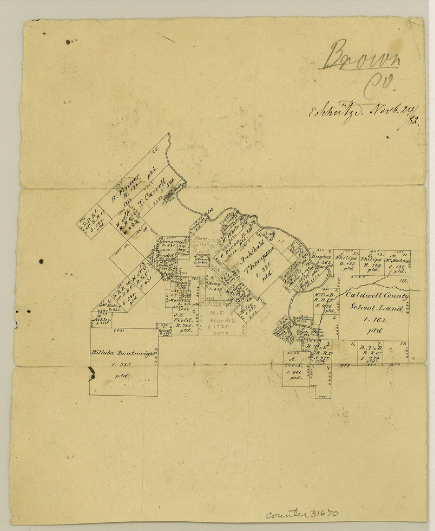
Mills County Sketch File 22
[Office sketch of area along Pecan Bayou northwest of Goldthwaite]
-
Map/Doc
31670
-
Collection
General Map Collection
-
Object Dates
11/24/1882 (Creation Date)
-
People and Organizations
E. Schutze (Draftsman)
-
Counties
Mills
-
Subjects
Surveying Sketch File
-
Height x Width
9.8 x 8.0 inches
24.9 x 20.3 cm
-
Medium
paper, manuscript
Part of: General Map Collection
Reagan County Working Sketch 21

Print $20.00
- Digital $50.00
Reagan County Working Sketch 21
1955
Size 23.4 x 19.9 inches
Map/Doc 71863
Lubbock County Sketch File 7

Print $8.00
- Digital $50.00
Lubbock County Sketch File 7
1906
Size 7.4 x 8.5 inches
Map/Doc 30422
Atascosa County Rolled Sketch 14

Print $20.00
- Digital $50.00
Atascosa County Rolled Sketch 14
1944
Size 37.1 x 46.0 inches
Map/Doc 8430
Motley County Sketch File 12 (N)

Print $3.00
- Digital $50.00
Motley County Sketch File 12 (N)
Size 20.0 x 18.4 inches
Map/Doc 42141
Kimble County Working Sketch 63

Print $20.00
- Digital $50.00
Kimble County Working Sketch 63
1964
Size 31.2 x 34.2 inches
Map/Doc 70131
Webb County Working Sketch 12

Print $20.00
- Digital $50.00
Webb County Working Sketch 12
1921
Size 15.9 x 14.6 inches
Map/Doc 72377
Sketch Showing Surveys Made for W. R. Cartledge

Print $20.00
- Digital $50.00
Sketch Showing Surveys Made for W. R. Cartledge
1945
Size 17.3 x 13.8 inches
Map/Doc 60296
Schleicher County Sketch File 27

Print $20.00
- Digital $50.00
Schleicher County Sketch File 27
Size 23.0 x 19.2 inches
Map/Doc 12305
Aransas County Sketch File 27

Print $23.00
- Digital $50.00
Aransas County Sketch File 27
Size 12.2 x 18.2 inches
Map/Doc 13224
Edwards County Working Sketch 99

Print $20.00
- Digital $50.00
Edwards County Working Sketch 99
1970
Size 36.3 x 27.9 inches
Map/Doc 68975
Comanche County Working Sketch 5

Print $20.00
- Digital $50.00
Comanche County Working Sketch 5
1919
Size 31.8 x 28.9 inches
Map/Doc 68139
Wilbarger County Working Sketch 13

Print $20.00
- Digital $50.00
Wilbarger County Working Sketch 13
1954
Size 25.9 x 24.0 inches
Map/Doc 72551
You may also like
Stonewall County Working Sketch 17

Print $20.00
- Digital $50.00
Stonewall County Working Sketch 17
1954
Size 31.5 x 24.7 inches
Map/Doc 62324
Mrs. Don D. Kinnebrew Farm Section 72, Block A

Print $20.00
- Digital $50.00
Mrs. Don D. Kinnebrew Farm Section 72, Block A
Size 15.6 x 18.0 inches
Map/Doc 92290
Kinney County Rolled Sketch 17

Print $20.00
- Digital $50.00
Kinney County Rolled Sketch 17
1965
Size 18.4 x 21.5 inches
Map/Doc 6544
[Blk. Y2, B. & B. Blk. 5, T. T. Blk. T, North line of H. & G. N. Blk. 4]
![90140, [Blk. Y2, B. & B. Blk. 5, T. T. Blk. T, North line of H. & G. N. Blk. 4], Twichell Survey Records](https://historictexasmaps.com/wmedia_w700/maps/90140-1.tif.jpg)
Print $20.00
- Digital $50.00
[Blk. Y2, B. & B. Blk. 5, T. T. Blk. T, North line of H. & G. N. Blk. 4]
Size 18.8 x 23.7 inches
Map/Doc 90140
Matagorda County Sketch File 7c

Print $8.00
- Digital $50.00
Matagorda County Sketch File 7c
1890
Size 14.3 x 8.8 inches
Map/Doc 30746
[Galveston, Harrisburg & San Antonio Railway]
![64404, [Galveston, Harrisburg & San Antonio Railway], General Map Collection](https://historictexasmaps.com/wmedia_w700/maps/64404.tif.jpg)
Print $20.00
- Digital $50.00
[Galveston, Harrisburg & San Antonio Railway]
1892
Size 13.8 x 34.0 inches
Map/Doc 64404
Mitchell County Boundary File 2

Print $4.00
- Digital $50.00
Mitchell County Boundary File 2
Size 8.9 x 7.3 inches
Map/Doc 57367
Pecos County Sketch File 85

Print $19.00
- Digital $50.00
Pecos County Sketch File 85
1948
Size 14.6 x 9.2 inches
Map/Doc 33955
Railroad Track Map, H&TCRRCo., Falls County, Texas

Print $4.00
- Digital $50.00
Railroad Track Map, H&TCRRCo., Falls County, Texas
1918
Size 11.8 x 18.4 inches
Map/Doc 62838
Map of Runnels County

Print $20.00
- Digital $50.00
Map of Runnels County
1898
Size 44.7 x 39.5 inches
Map/Doc 63008
Hutchinson County Sketch File 48

Print $38.00
- Digital $50.00
Hutchinson County Sketch File 48
1989
Size 11.2 x 8.8 inches
Map/Doc 27400
Hunt County Rolled Sketch 5

Print $20.00
- Digital $50.00
Hunt County Rolled Sketch 5
1956
Size 22.9 x 23.0 inches
Map/Doc 6272