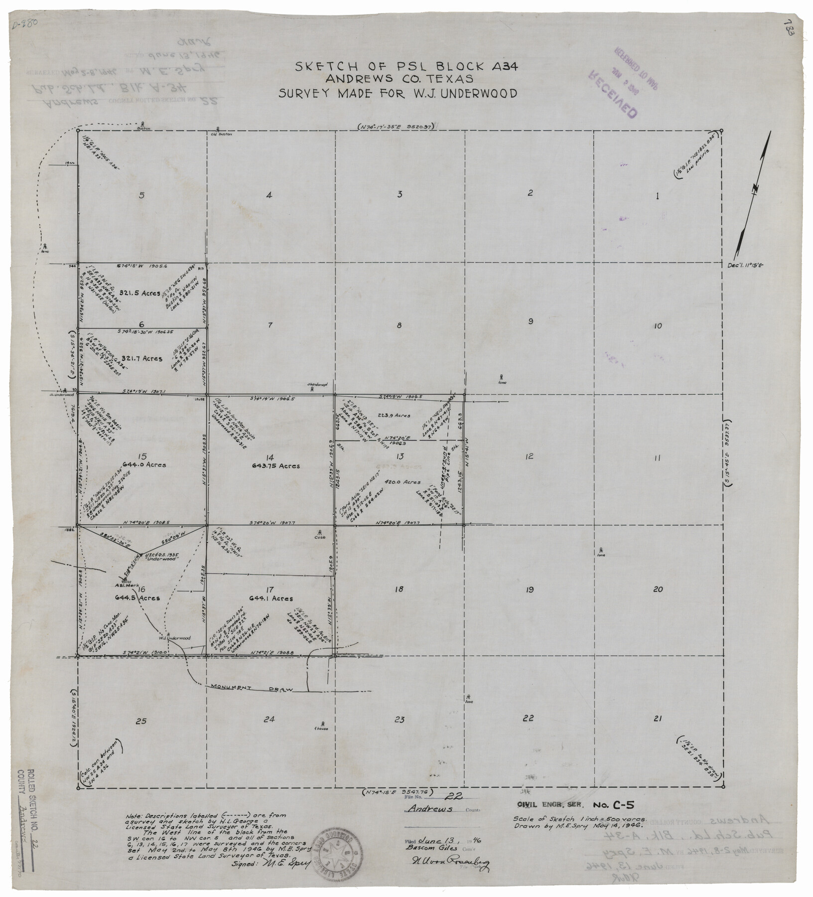
Andrews County Rolled Sketch 22
Sketch of PSL Block A34 Andrews Co. Texas - Survey made for W.J. Underwood
-
Map/Doc
77170
-
Collection
General Map Collection
-
Object Dates
1946/5/14 (Creation Date)
1946/6/13 (File Date)
1946/5/8 (Survey Date)
-
People and Organizations
M.E. Spry (Surveyor/Engineer)
M.E. Spry (Draftsman)
-
Counties
Andrews
-
Subjects
Surveying Rolled Sketch
-
Height x Width
26.4 x 24.0 inches
67.1 x 61.0 cm
-
Medium
linen, manuscript
-
Scale
1" = 500 varas
Part of: General Map Collection
Young County Working Sketch 10

Print $20.00
- Digital $50.00
Young County Working Sketch 10
1921
Size 24.4 x 34.4 inches
Map/Doc 62033
Duval County Sketch File B

Print $20.00
- Digital $50.00
Duval County Sketch File B
1880
Size 15.5 x 20.6 inches
Map/Doc 11412
Presidio County Sketch File 105

Print $20.00
- Digital $50.00
Presidio County Sketch File 105
Size 13.1 x 20.6 inches
Map/Doc 82962
Texas-Indian Territory Gainesville Quadrangle

Print $20.00
- Digital $50.00
Texas-Indian Territory Gainesville Quadrangle
1913
Size 20.4 x 16.9 inches
Map/Doc 75103
Real County Working Sketch 23

Print $20.00
- Digital $50.00
Real County Working Sketch 23
1946
Size 20.4 x 23.4 inches
Map/Doc 71915
Gulf of Mexico

Print $20.00
- Digital $50.00
Gulf of Mexico
1900
Size 18.4 x 28.1 inches
Map/Doc 72649
Flight Mission No. BRA-7M, Frame 142, Jefferson County

Print $20.00
- Digital $50.00
Flight Mission No. BRA-7M, Frame 142, Jefferson County
1953
Size 18.6 x 22.5 inches
Map/Doc 85536
Baylor County Sketch File A10

Print $8.00
- Digital $50.00
Baylor County Sketch File A10
1927
Size 11.3 x 8.9 inches
Map/Doc 14100
Montgomery County Working Sketch 8a

Print $20.00
- Digital $50.00
Montgomery County Working Sketch 8a
1932
Size 17.8 x 20.4 inches
Map/Doc 71114
Briscoe County Sketch File 13

Print $168.00
- Digital $50.00
Briscoe County Sketch File 13
1982
Size 11.2 x 8.7 inches
Map/Doc 16428
Uvalde County Working Sketch 3

Print $20.00
- Digital $50.00
Uvalde County Working Sketch 3
1915
Size 37.9 x 34.1 inches
Map/Doc 72073
Falls County Sketch File 19

Print $4.00
- Digital $50.00
Falls County Sketch File 19
1871
Size 12.8 x 8.4 inches
Map/Doc 22386
You may also like
Pecos County Rolled Sketch 146B

Print $20.00
- Digital $50.00
Pecos County Rolled Sketch 146B
Size 42.3 x 37.8 inches
Map/Doc 9742
Lampasas County Working Sketch 14

Print $20.00
- Digital $50.00
Lampasas County Working Sketch 14
1974
Size 23.4 x 21.8 inches
Map/Doc 70291
Val Verde County Working Sketch 118

Print $40.00
- Digital $50.00
Val Verde County Working Sketch 118
2005
Size 29.6 x 50.0 inches
Map/Doc 83587
Real County Rolled Sketch 17

Print $20.00
- Digital $50.00
Real County Rolled Sketch 17
1906
Size 25.1 x 28.8 inches
Map/Doc 7459
San Luis Pass to East Matagorda Bay

Print $40.00
- Digital $50.00
San Luis Pass to East Matagorda Bay
1991
Size 35.0 x 48.8 inches
Map/Doc 69972
General Highway Map, Atascosa County, Texas

Print $20.00
General Highway Map, Atascosa County, Texas
1940
Size 18.2 x 24.9 inches
Map/Doc 79008
Flight Mission No. DQO-8K, Frame 72, Galveston County

Print $20.00
- Digital $50.00
Flight Mission No. DQO-8K, Frame 72, Galveston County
1952
Size 18.7 x 22.4 inches
Map/Doc 85176
Brewster County Rolled Sketch 78

Print $20.00
- Digital $50.00
Brewster County Rolled Sketch 78
1945
Size 19.8 x 28.0 inches
Map/Doc 5243
Dimmit County Working Sketch 8

Print $20.00
- Digital $50.00
Dimmit County Working Sketch 8
1930
Size 35.8 x 29.9 inches
Map/Doc 68669
Tyler County Rolled Sketch 7

Print $20.00
- Digital $50.00
Tyler County Rolled Sketch 7
1960
Size 40.0 x 46.5 inches
Map/Doc 10030
Sutton County Working Sketch 38

Print $20.00
- Digital $50.00
Sutton County Working Sketch 38
1942
Size 35.2 x 26.1 inches
Map/Doc 62381
Galveston County Working Sketch 3

Print $20.00
- Digital $50.00
Galveston County Working Sketch 3
1915
Size 21.4 x 19.5 inches
Map/Doc 69340