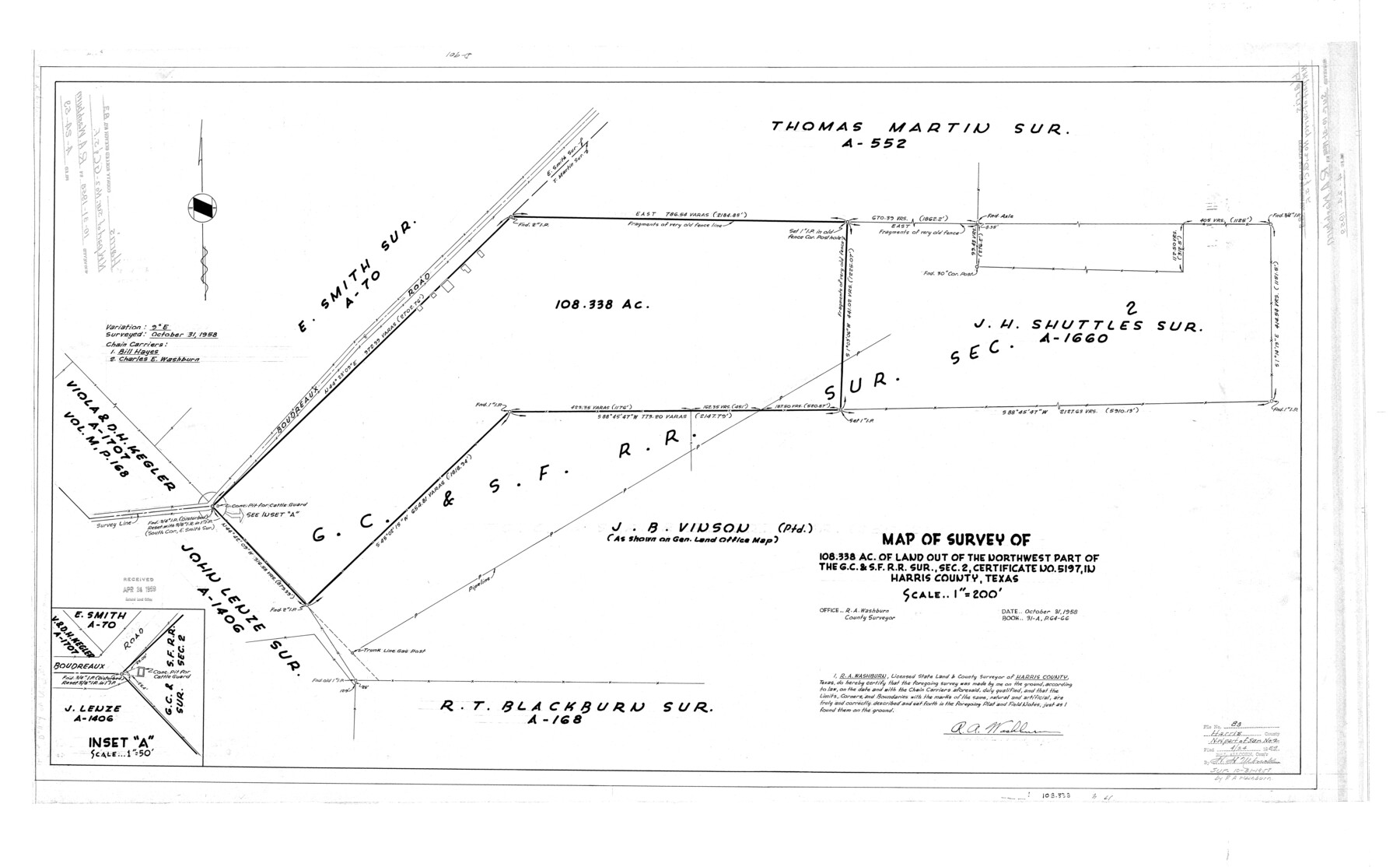
Harris County Rolled Sketch 83
Map of survey of 108.338 ac. of land out of the northwest part of the G. C. & S. F. R.R. sur., sec. 2, certificate no. 5197, in Harris County, Texas
-
Map/Doc
9139
-
Collection
General Map Collection
-
Object Dates
1958/10/31 (Creation Date)
1959/4/24 (File Date)
-
People and Organizations
R.A. Washburn (Surveyor/Engineer)
Bill Hayes (Chainman/Field Personnel)
Charles E. Washburn (Chainman/Field Personnel)
-
Counties
Harris
-
Subjects
Surveying Rolled Sketch
-
Height x Width
28.2 x 45.6 inches
71.6 x 115.8 cm
-
Scale
1" = 200 feet
Part of: General Map Collection
Wilson County Working Sketch 9

Print $20.00
- Digital $50.00
Wilson County Working Sketch 9
1979
Size 31.6 x 33.0 inches
Map/Doc 72589
Nueces County Rolled Sketch 85

Print $72.00
Nueces County Rolled Sketch 85
1982
Size 18.5 x 24.9 inches
Map/Doc 6971
Chambers County NRC Article 33.136 Location Key Sheet

Print $20.00
- Digital $50.00
Chambers County NRC Article 33.136 Location Key Sheet
1982
Size 27.0 x 22.3 inches
Map/Doc 82999
Concho County Sketch File 43

Print $6.00
- Digital $50.00
Concho County Sketch File 43
1948
Size 14.4 x 8.9 inches
Map/Doc 19204
Mitchell County

Print $20.00
- Digital $50.00
Mitchell County
1889
Size 42.3 x 35.7 inches
Map/Doc 10792
Jasper County

Print $40.00
- Digital $50.00
Jasper County
1898
Size 64.2 x 35.6 inches
Map/Doc 78413

El Paso County Working Sketch 8

Print $20.00
- Digital $50.00
El Paso County Working Sketch 8
1952
Size 23.9 x 22.5 inches
Map/Doc 69030
Hamilton County Working Sketch 3

Print $20.00
- Digital $50.00
Hamilton County Working Sketch 3
1926
Size 29.6 x 39.6 inches
Map/Doc 63341
Wharton County Sketch File 9

Print $4.00
- Digital $50.00
Wharton County Sketch File 9
1884
Size 9.1 x 11.7 inches
Map/Doc 39929
Sterling County Rolled Sketch 22

Print $20.00
- Digital $50.00
Sterling County Rolled Sketch 22
Size 33.6 x 30.8 inches
Map/Doc 9953
Tom Green County

Print $40.00
- Digital $50.00
Tom Green County
1942
Size 55.3 x 46.8 inches
Map/Doc 73304
You may also like
Pecos County, 1917

Print $20.00
- Digital $50.00
Pecos County, 1917
1917
Size 40.5 x 47.4 inches
Map/Doc 89707
Map of Live Oak County

Print $20.00
- Digital $50.00
Map of Live Oak County
1878
Size 27.4 x 20.8 inches
Map/Doc 3823
Upton County Rolled Sketch 52

Print $20.00
- Digital $50.00
Upton County Rolled Sketch 52
Size 24.5 x 29.2 inches
Map/Doc 8087
Crockett County Rolled Sketch CRV

Print $40.00
- Digital $50.00
Crockett County Rolled Sketch CRV
1925
Size 35.8 x 52.3 inches
Map/Doc 8693
[Sketch for Mineral Application 26501 - Sabine River, T. A. Oldhausen]
![2844, [Sketch for Mineral Application 26501 - Sabine River, T. A. Oldhausen], General Map Collection](https://historictexasmaps.com/wmedia_w700/maps/2844.tif.jpg)
Print $20.00
- Digital $50.00
[Sketch for Mineral Application 26501 - Sabine River, T. A. Oldhausen]
1931
Size 24.4 x 36.8 inches
Map/Doc 2844
Map of Maverick County

Print $20.00
- Digital $50.00
Map of Maverick County
1874
Size 31.5 x 20.9 inches
Map/Doc 3848
Pecos County Working Sketch 139

Print $20.00
- Digital $50.00
Pecos County Working Sketch 139
1982
Size 31.1 x 24.9 inches
Map/Doc 71613
Duval County Sketch File 20

Print $20.00
- Digital $50.00
Duval County Sketch File 20
1880
Size 17.9 x 14.6 inches
Map/Doc 11384
Flight Mission No. CUG-1P, Frame 106, Kleberg County

Print $20.00
- Digital $50.00
Flight Mission No. CUG-1P, Frame 106, Kleberg County
1956
Size 18.8 x 22.3 inches
Map/Doc 86156
Flight Mission No. DQN-1K, Frame 73, Calhoun County

Print $20.00
- Digital $50.00
Flight Mission No. DQN-1K, Frame 73, Calhoun County
1953
Size 18.5 x 22.2 inches
Map/Doc 84160
Crane County Working Sketch Graphic Index, Sheet A

Print $20.00
- Digital $50.00
Crane County Working Sketch Graphic Index, Sheet A
1945
Size 44.6 x 33.3 inches
Map/Doc 76507
Flight Mission No. BRA-16M, Frame 55, Jefferson County

Print $20.00
- Digital $50.00
Flight Mission No. BRA-16M, Frame 55, Jefferson County
1953
Size 18.4 x 22.4 inches
Map/Doc 85672