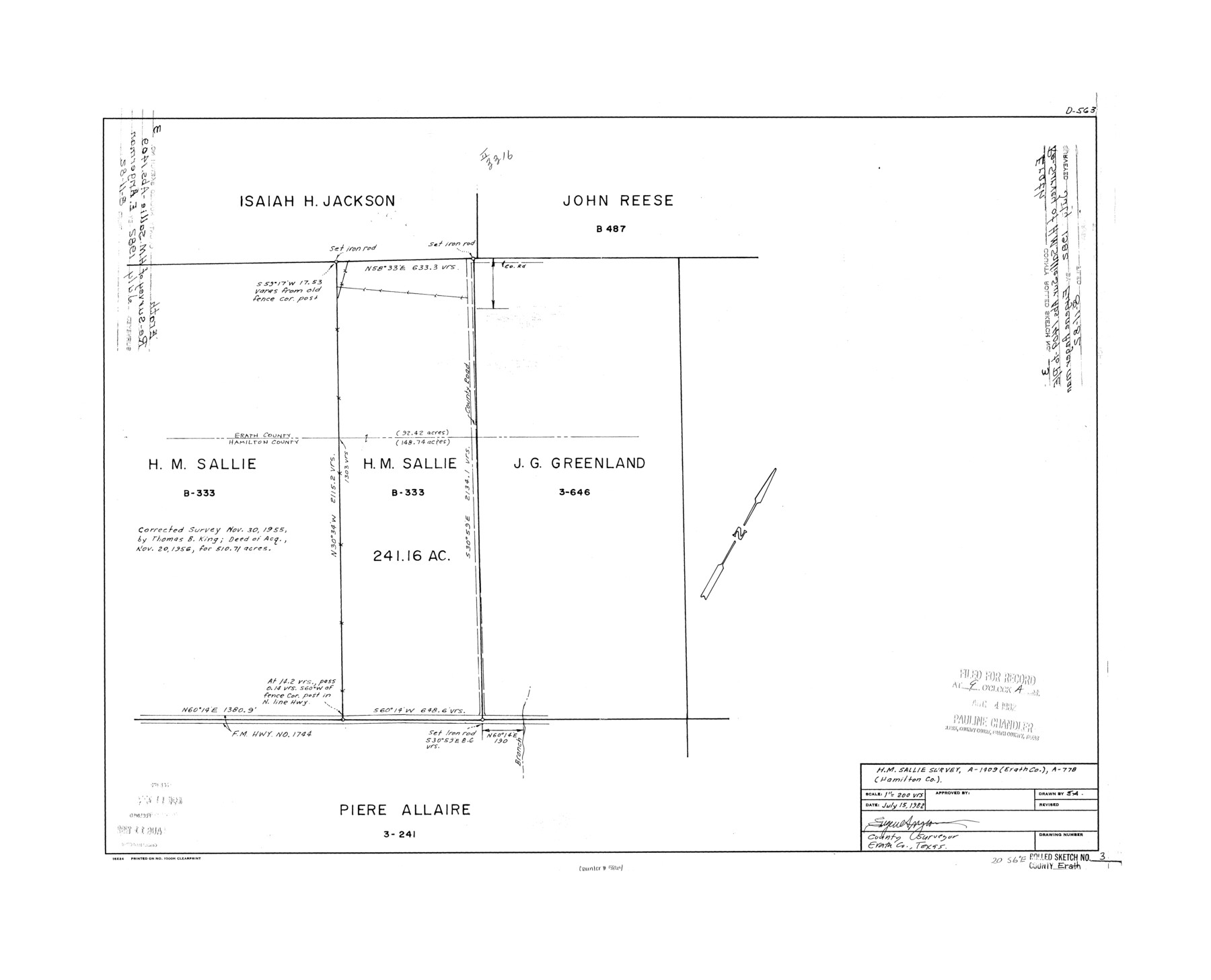
Erath County Rolled Sketch 3
H.M. Sallie survey, A-1409 (Erath Co.), A-778 (Hamilton Co.)
-
Map/Doc
5864
-
Collection
General Map Collection
-
Object Dates
1982/7/15 (Creation Date)
1982/8/11 (File Date)
-
People and Organizations
Eugene Angermann (Surveyor/Engineer)
Eugene Angermann (Draftsman)
-
Counties
Erath Hamilton
-
Subjects
Surveying Rolled Sketch
-
Height x Width
22.6 x 27.9 inches
57.4 x 70.9 cm
-
Medium
mylar, print
-
Scale
1" = 200 varas
Part of: General Map Collection
Lynn County Sketch File 20

Print $4.00
- Digital $50.00
Lynn County Sketch File 20
1891
Size 8.8 x 10.9 inches
Map/Doc 30527
Cuadro Geografico y Estadistico

Print $20.00
- Digital $50.00
Cuadro Geografico y Estadistico
Size 23.1 x 30.9 inches
Map/Doc 96982
Erath County Working Sketch 12

Print $20.00
- Digital $50.00
Erath County Working Sketch 12
1964
Size 22.3 x 23.1 inches
Map/Doc 69093
Flight Mission No. DCL-4C, Frame 123, Kenedy County

Print $20.00
- Digital $50.00
Flight Mission No. DCL-4C, Frame 123, Kenedy County
1943
Size 18.6 x 22.3 inches
Map/Doc 85822
Donley County Working Sketch 10

Print $20.00
- Digital $50.00
Donley County Working Sketch 10
1982
Size 35.1 x 41.1 inches
Map/Doc 68743
Frio County Working Sketch 25

Print $40.00
- Digital $50.00
Frio County Working Sketch 25
1989
Size 35.4 x 50.0 inches
Map/Doc 69299
Tarrant County Sketch File 3

Print $4.00
- Digital $50.00
Tarrant County Sketch File 3
Size 11.8 x 8.2 inches
Map/Doc 37676

Flight Mission No. DIX-10P, Frame 61, Aransas County

Print $20.00
- Digital $50.00
Flight Mission No. DIX-10P, Frame 61, Aransas County
1956
Size 18.7 x 22.5 inches
Map/Doc 83922
Denton County Working Sketch 19

Print $20.00
- Digital $50.00
Denton County Working Sketch 19
1976
Size 24.3 x 27.3 inches
Map/Doc 68624
Palo Pinto County Boundary File 4b

Print $38.00
- Digital $50.00
Palo Pinto County Boundary File 4b
Size 13.6 x 8.6 inches
Map/Doc 57824
Smith County Rolled Sketch 1

Print $20.00
- Digital $50.00
Smith County Rolled Sketch 1
Size 42.4 x 34.8 inches
Map/Doc 9932
You may also like
Zavala County Working Sketch 9

Print $20.00
- Digital $50.00
Zavala County Working Sketch 9
1951
Size 42.0 x 36.4 inches
Map/Doc 62084
Blocks No. 8, 9 & 10 Houston & Great Northern Rail Road Company Surveys in Pecos County, Texas

Print $20.00
- Digital $50.00
Blocks No. 8, 9 & 10 Houston & Great Northern Rail Road Company Surveys in Pecos County, Texas
1891
Size 24.5 x 38.7 inches
Map/Doc 3955
Floyd County Boundary File 2a

Print $40.00
- Digital $50.00
Floyd County Boundary File 2a
Size 19.8 x 39.2 inches
Map/Doc 53488

Hutchinson County Rolled Sketch 40

Print $20.00
- Digital $50.00
Hutchinson County Rolled Sketch 40
1981
Size 26.8 x 37.6 inches
Map/Doc 6301
Wharton County Working Sketch 9

Print $3.00
- Digital $50.00
Wharton County Working Sketch 9
1982
Size 12.4 x 10.4 inches
Map/Doc 72473
Ochiltree County Boundary File 5a

Print $10.00
- Digital $50.00
Ochiltree County Boundary File 5a
Size 13.7 x 8.7 inches
Map/Doc 57692
United States - Gulf Coast Texas - Northern part of Laguna Madre

Print $20.00
- Digital $50.00
United States - Gulf Coast Texas - Northern part of Laguna Madre
1923
Size 26.6 x 18.3 inches
Map/Doc 72931
Webb County Working Sketch 61

Print $20.00
- Digital $50.00
Webb County Working Sketch 61
1960
Size 24.7 x 28.0 inches
Map/Doc 72427
Plano, Collin County, Texas

Print $20.00
Plano, Collin County, Texas
1891
Size 12.8 x 22.6 inches
Map/Doc 93758
La Salle County Rolled Sketch 27

Print $20.00
- Digital $50.00
La Salle County Rolled Sketch 27
1979
Size 29.0 x 38.2 inches
Map/Doc 6588
Atascosa County Sketch File 15a

Print $5.00
- Digital $50.00
Atascosa County Sketch File 15a
1879
Size 17.4 x 8.2 inches
Map/Doc 13777