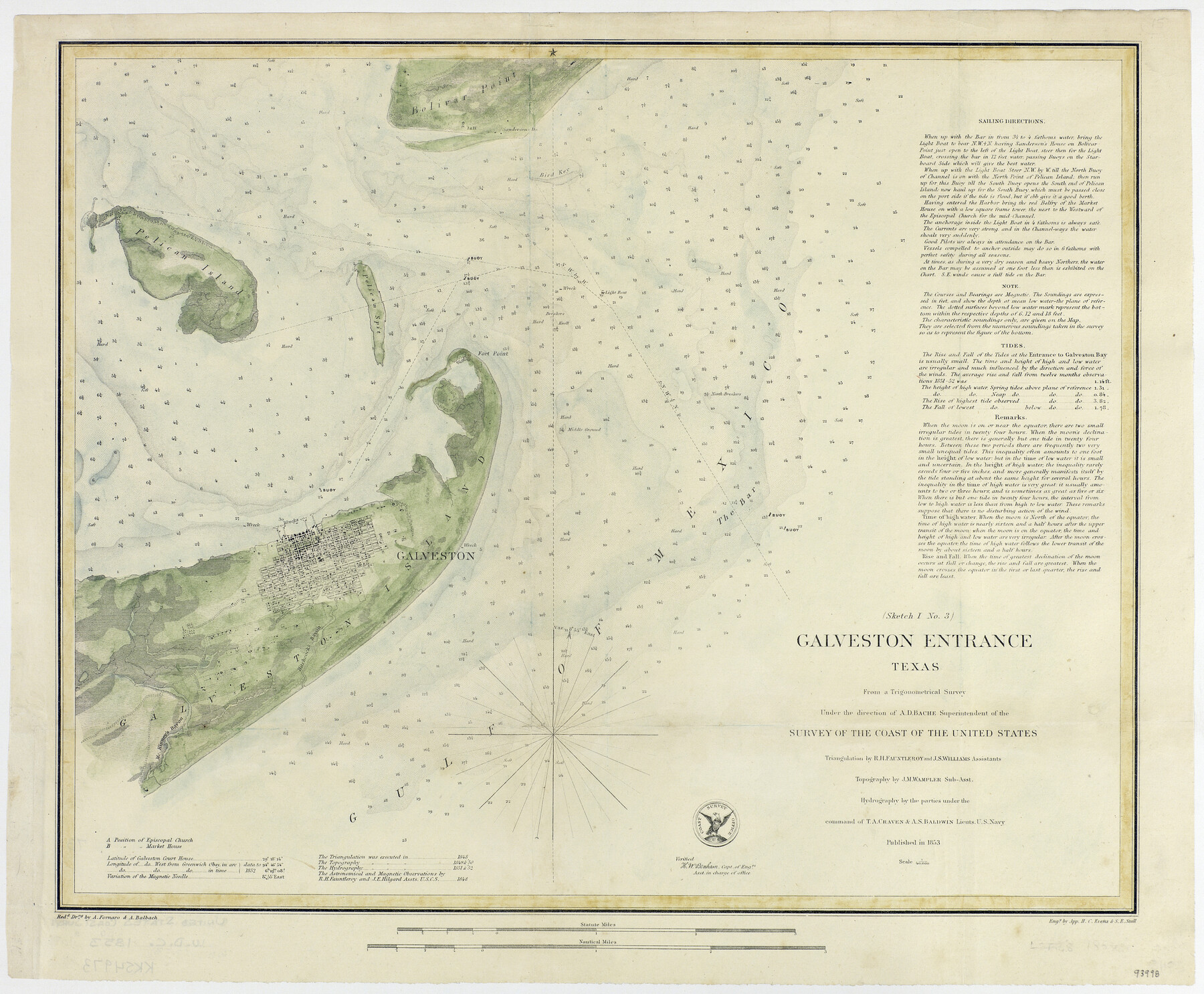
Galveston Entrance, Texas From a Trigonometrical Survey Under the direction of A.D. Bache Superintendent of the Survey of the Coast of the United States
-
Map/Doc
93998
-
Collection
General Map Collection
-
Object Dates
1853 (Creation Date)
-
People and Organizations
U.S. Coast Survey Office (Publisher)
-
Subjects
Gulf of Mexico Nautical Charts
-
Height x Width
15.9 x 19.3 inches
40.4 x 49.0 cm
-
Medium
paper, etching/engraving/lithograph
-
Comments
Conservation funded by the Summerlee Foundation.
Part of: General Map Collection
Flight Mission No. DAG-21K, Frame 84, Matagorda County

Print $20.00
- Digital $50.00
Flight Mission No. DAG-21K, Frame 84, Matagorda County
1952
Size 18.6 x 22.3 inches
Map/Doc 86413
Wheeler County Working Sketch 20

Print $20.00
- Digital $50.00
Wheeler County Working Sketch 20
1989
Size 40.4 x 32.6 inches
Map/Doc 72509
Flight Mission No. CRC-5R, Frame 21, Chambers County

Print $20.00
- Digital $50.00
Flight Mission No. CRC-5R, Frame 21, Chambers County
1956
Size 18.6 x 22.3 inches
Map/Doc 84943
Flight Mission No. CRC-4R, Frame 159, Chambers County

Print $20.00
- Digital $50.00
Flight Mission No. CRC-4R, Frame 159, Chambers County
1956
Size 18.6 x 22.2 inches
Map/Doc 84918
Montgomery County Working Sketch 72

Print $20.00
- Digital $50.00
Montgomery County Working Sketch 72
1979
Size 17.2 x 32.4 inches
Map/Doc 71179
Culberson County Working Sketch 42

Print $40.00
- Digital $50.00
Culberson County Working Sketch 42
1970
Size 49.1 x 44.0 inches
Map/Doc 68496
Chambers County Sketch File 9

Print $10.00
- Digital $50.00
Chambers County Sketch File 9
1872
Size 10.3 x 11.8 inches
Map/Doc 17546
Atascosa County Sketch File 27c

Print $12.00
- Digital $50.00
Atascosa County Sketch File 27c
1876
Size 12.7 x 8.4 inches
Map/Doc 13806
Williamson County Working Sketch 6

Print $20.00
- Digital $50.00
Williamson County Working Sketch 6
1938
Size 11.2 x 18.6 inches
Map/Doc 72566
Limestone County

Print $40.00
- Digital $50.00
Limestone County
1922
Size 48.1 x 35.4 inches
Map/Doc 16880
Flight Mission No. BRA-7M, Frame 181, Jefferson County

Print $20.00
- Digital $50.00
Flight Mission No. BRA-7M, Frame 181, Jefferson County
1953
Size 18.6 x 22.4 inches
Map/Doc 85549
Presidio County Sketch File 100

Print $4.00
- Digital $50.00
Presidio County Sketch File 100
1963
Size 11.2 x 8.9 inches
Map/Doc 34791
You may also like
Carson County Boundary File 9

Print $74.00
- Digital $50.00
Carson County Boundary File 9
Size 9.0 x 8.9 inches
Map/Doc 51175
Sabine Bank to East Bay including Heald Bank

Print $20.00
- Digital $50.00
Sabine Bank to East Bay including Heald Bank
1967
Size 45.1 x 34.3 inches
Map/Doc 69848
Pecos County Working Sketch 122

Print $40.00
- Digital $50.00
Pecos County Working Sketch 122
1973
Size 51.9 x 36.7 inches
Map/Doc 71595
Reeves County Sketch File 9

Print $20.00
- Digital $50.00
Reeves County Sketch File 9
Size 46.3 x 38.2 inches
Map/Doc 10587
Jim Wells Co.

Print $20.00
- Digital $50.00
Jim Wells Co.
1966
Size 40.3 x 28.9 inches
Map/Doc 77331
Andrews County Sketch File 13

Print $12.00
- Digital $50.00
Andrews County Sketch File 13
1979
Size 14.2 x 8.7 inches
Map/Doc 12863
Travis County Working Sketch 7

Print $2.00
- Digital $50.00
Travis County Working Sketch 7
1913
Size 10.9 x 8.2 inches
Map/Doc 69391
Cooke County Sketch File 9a

Print $4.00
- Digital $50.00
Cooke County Sketch File 9a
Size 8.2 x 9.4 inches
Map/Doc 19240
Kimble County Sketch File 3

Print $4.00
- Digital $50.00
Kimble County Sketch File 3
1847
Size 9.1 x 11.5 inches
Map/Doc 28910
Brewster County Sketch File NS-6

Print $40.00
- Digital $50.00
Brewster County Sketch File NS-6
1944
Size 31.8 x 18.6 inches
Map/Doc 10989
Liberty County Working Sketch 60

Print $20.00
- Digital $50.00
Liberty County Working Sketch 60
1969
Size 41.3 x 34.1 inches
Map/Doc 70520
Brazos Island Harbor, Texas - Dredging Entrance Channel Plan

Print $20.00
- Digital $50.00
Brazos Island Harbor, Texas - Dredging Entrance Channel Plan
1990
Size 14.5 x 20.1 inches
Map/Doc 83338