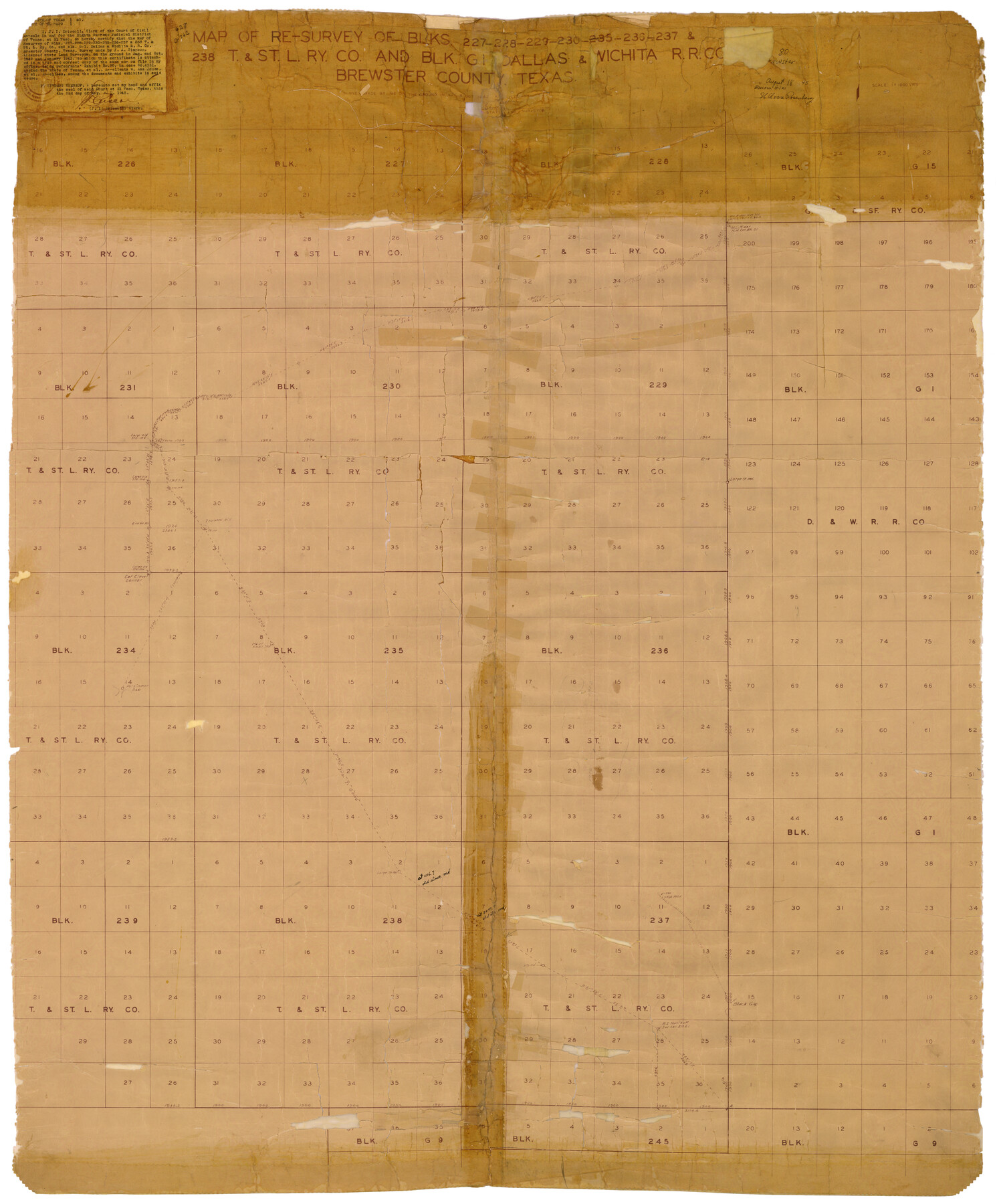
Brewster County Rolled Sketch 80
Map of re-survey of Blks 227-228-229-230-235-236-237 & 238, T. & St. L. Ry. Co. and Blk. G1, Dallas & Wichita R.R. Co.
-
Map/Doc
8493
-
Collection
General Map Collection
-
Object Dates
1943 (Creation Date)
1945/8/18 (File Date)
-
People and Organizations
J.A. Simpson (Surveyor/Engineer)
-
Counties
Brewster
-
Subjects
Surveying Rolled Sketch
-
Height x Width
51.6 x 42.7 inches
131.1 x 108.5 cm
-
Medium
van dyke/brownline/sepia
-
Scale
1" = 1000 varas
Part of: General Map Collection
Donley County Sketch File B10

Print $24.00
- Digital $50.00
Donley County Sketch File B10
1938
Size 14.3 x 9.1 inches
Map/Doc 21272
Gaines County Sketch File 15

Print $5.00
- Digital $50.00
Gaines County Sketch File 15
1956
Size 11.6 x 8.8 inches
Map/Doc 23202
Cameron County Rolled Sketch 25

Print $20.00
- Digital $50.00
Cameron County Rolled Sketch 25
1977
Size 24.8 x 36.8 inches
Map/Doc 5792
Crockett County Rolled Sketch 46

Print $20.00
- Digital $50.00
Crockett County Rolled Sketch 46
1938
Size 46.0 x 43.0 inches
Map/Doc 8711
Erath County Sketch File 3b

Print $4.00
- Digital $50.00
Erath County Sketch File 3b
Size 10.3 x 8.3 inches
Map/Doc 22257
Atascosa County Working Sketch 28

Print $20.00
- Digital $50.00
Atascosa County Working Sketch 28
1968
Size 38.5 x 26.3 inches
Map/Doc 67224
Liberty County Boundary File 1

Print $8.00
- Digital $50.00
Liberty County Boundary File 1
Size 14.2 x 8.9 inches
Map/Doc 56289
McCulloch County

Print $20.00
- Digital $50.00
McCulloch County
1874
Size 21.9 x 16.8 inches
Map/Doc 3856
Lipscomb County Boundary File 1

Print $16.00
- Digital $50.00
Lipscomb County Boundary File 1
Size 9.0 x 8.0 inches
Map/Doc 56307
Red River County Working Sketch 81-3

Print $20.00
- Digital $50.00
Red River County Working Sketch 81-3
1987
Size 17.5 x 21.5 inches
Map/Doc 72066
Harris County Working Sketch 67

Print $20.00
- Digital $50.00
Harris County Working Sketch 67
1955
Size 23.3 x 27.5 inches
Map/Doc 65959
Current Miscellaneous File 49

Print $4.00
- Digital $50.00
Current Miscellaneous File 49
Size 11.2 x 8.8 inches
Map/Doc 74012
You may also like
Newton County Rolled Sketch 24
Print $20.00
- Digital $50.00
Newton County Rolled Sketch 24
1893
Size 18.8 x 20.8 inches
Map/Doc 6851
Nueces County Rolled Sketch 118

Print $20.00
- Digital $50.00
Nueces County Rolled Sketch 118
1988
Size 19.5 x 35.4 inches
Map/Doc 7150
Chambers County Working Sketch 20

Print $20.00
- Digital $50.00
Chambers County Working Sketch 20
1973
Size 25.8 x 30.2 inches
Map/Doc 68003
Maps of Gulf Intracoastal Waterway, Texas - Sabine River to the Rio Grande and connecting waterways including ship channels

Print $20.00
- Digital $50.00
Maps of Gulf Intracoastal Waterway, Texas - Sabine River to the Rio Grande and connecting waterways including ship channels
1966
Size 14.5 x 22.3 inches
Map/Doc 61921
Old Miscellaneous File 2

Print $16.00
- Digital $50.00
Old Miscellaneous File 2
1838
Size 13.0 x 8.0 inches
Map/Doc 75406
San Jacinto County Working Sketch 15

Print $20.00
- Digital $50.00
San Jacinto County Working Sketch 15
1935
Size 32.0 x 36.5 inches
Map/Doc 63728
Principal Highways of the Southwest with particular reference to New Mexico, Oklahoma, Texas, Arkansas and Louisiana

Print $20.00
Principal Highways of the Southwest with particular reference to New Mexico, Oklahoma, Texas, Arkansas and Louisiana
1933
Size 24.3 x 18.4 inches
Map/Doc 76302

Laneer vs. Bivins, Potter County, Texas

Print $20.00
- Digital $50.00
Laneer vs. Bivins, Potter County, Texas
Size 21.7 x 19.0 inches
Map/Doc 93103
Terry County Rolled Sketch 11

Print $20.00
- Digital $50.00
Terry County Rolled Sketch 11
2022
Size 37.1 x 25.1 inches
Map/Doc 97101
Sketch in Lynn, Terry, Gaines and Dawson Counties

Print $40.00
- Digital $50.00
Sketch in Lynn, Terry, Gaines and Dawson Counties
1940
Size 53.2 x 33.1 inches
Map/Doc 92060
Flight Mission No. CRC-3R, Frame 207, Chambers County

Print $20.00
- Digital $50.00
Flight Mission No. CRC-3R, Frame 207, Chambers County
1956
Size 18.6 x 22.3 inches
Map/Doc 84862