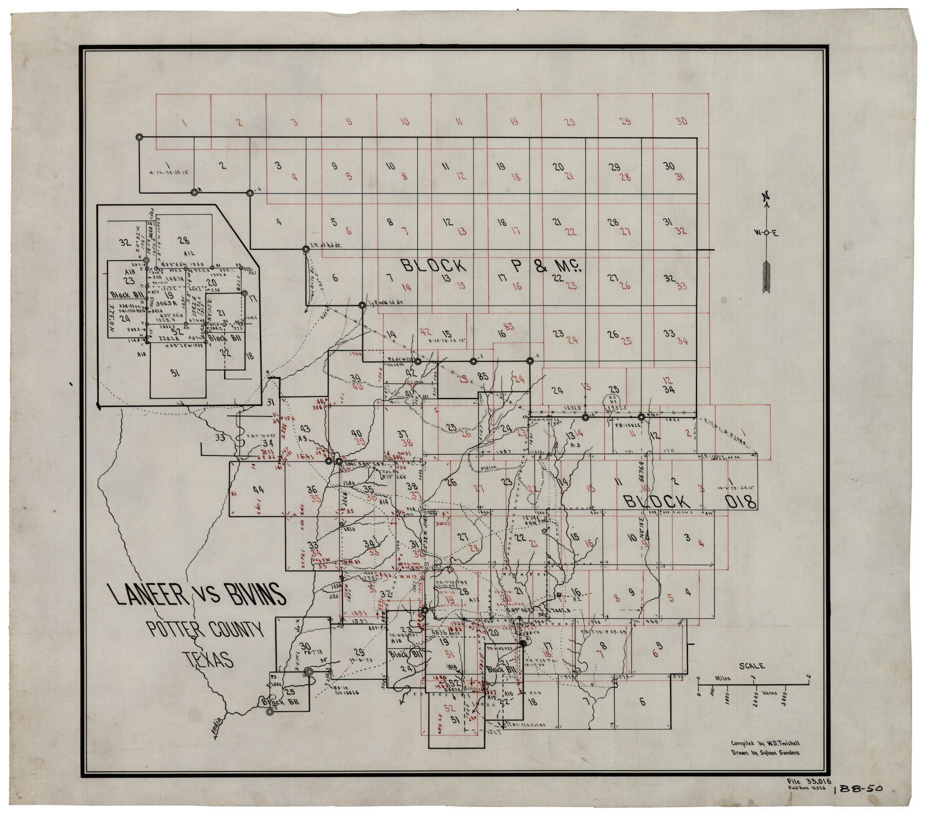
Laneer vs. Bivins, Potter County, Texas
188-50
-
Map/Doc
93103
-
Collection
Twichell Survey Records
-
People and Organizations
Sylvan Sanders (Draftsman)
W.D. Twichell (Compiler)
-
Counties
Potter
-
Height x Width
21.7 x 19.0 inches
55.1 x 48.3 cm
Part of: Twichell Survey Records
Sketch from Reeves and Pecos Co's.

Print $20.00
- Digital $50.00
Sketch from Reeves and Pecos Co's.
Size 35.1 x 26.1 inches
Map/Doc 91779
[Part of Map Showing Terry & Lynn County Line Highlighting Parts of Blocks D8, E, 9]
![92264, [Part of Map Showing Terry & Lynn County Line Highlighting Parts of Blocks D8, E, 9], Twichell Survey Records](https://historictexasmaps.com/wmedia_w700/maps/92264-1.tif.jpg)
Print $20.00
- Digital $50.00
[Part of Map Showing Terry & Lynn County Line Highlighting Parts of Blocks D8, E, 9]
Size 18.2 x 10.9 inches
Map/Doc 92264
Subdivisions of Survey #1, Block Z

Print $20.00
- Digital $50.00
Subdivisions of Survey #1, Block Z
Size 7.6 x 39.2 inches
Map/Doc 90580
Amarillo City Stock Yards

Print $20.00
- Digital $50.00
Amarillo City Stock Yards
Size 21.6 x 12.2 inches
Map/Doc 91745
[Blocks 44, 6T, 26, B10, and B12]
![91528, [Blocks 44, 6T, 26, B10, and B12], Twichell Survey Records](https://historictexasmaps.com/wmedia_w700/maps/91528-1.tif.jpg)
Print $20.00
- Digital $50.00
[Blocks 44, 6T, 26, B10, and B12]
Size 19.7 x 15.8 inches
Map/Doc 91528
[Blocks GP and T]
![91509, [Blocks GP and T], Twichell Survey Records](https://historictexasmaps.com/wmedia_w700/maps/91509-1.tif.jpg)
Print $20.00
- Digital $50.00
[Blocks GP and T]
Size 26.0 x 24.6 inches
Map/Doc 91509
Subdivisions of Capitol Leagues 112, 113, 114, 115, and parts of 110 and 111

Print $2.00
- Digital $50.00
Subdivisions of Capitol Leagues 112, 113, 114, 115, and parts of 110 and 111
1906
Size 6.3 x 8.3 inches
Map/Doc 90518
[John P. Rohus and surrounding surveys]
![90975, [John P. Rohus and surrounding surveys], Twichell Survey Records](https://historictexasmaps.com/wmedia_w700/maps/90975-1.tif.jpg)
Print $20.00
- Digital $50.00
[John P. Rohus and surrounding surveys]
Size 26.2 x 20.0 inches
Map/Doc 90975
Seagraves, Gaines County, Texas, Located in Surveys 10 and 15, Block C-34

Print $20.00
- Digital $50.00
Seagraves, Gaines County, Texas, Located in Surveys 10 and 15, Block C-34
Size 33.3 x 23.8 inches
Map/Doc 92687
[Letter from T. F. Pinckney to W. D. Twichell accompanying sketch showing Blocks 14, 341, and G5]
![93110, [Letter from T. F. Pinckney to W. D. Twichell accompanying sketch showing Blocks 14, 341, and G5], Twichell Survey Records](https://historictexasmaps.com/wmedia_w700/maps/93110-1.tif.jpg)
Print $2.00
- Digital $50.00
[Letter from T. F. Pinckney to W. D. Twichell accompanying sketch showing Blocks 14, 341, and G5]
1911
Size 8.0 x 9.5 inches
Map/Doc 93110
Map Showing Blocks 15, 16 & 18 S.P.R.R.Co.

Print $20.00
- Digital $50.00
Map Showing Blocks 15, 16 & 18 S.P.R.R.Co.
1933
Size 24.7 x 19.1 inches
Map/Doc 92282
[T.& P.R.R.Co., Block 1]
![92963, [T.& P.R.R.Co., Block 1], Twichell Survey Records](https://historictexasmaps.com/wmedia_w700/maps/92963-1.tif.jpg)
Print $20.00
- Digital $50.00
[T.& P.R.R.Co., Block 1]
Size 37.5 x 31.6 inches
Map/Doc 92963
You may also like
Subdivision of Capitol Leagues 112, 113, 114, and 115, and Parts of 110, and 111

Print $20.00
- Digital $50.00
Subdivision of Capitol Leagues 112, 113, 114, and 115, and Parts of 110, and 111
1906
Size 18.5 x 23.3 inches
Map/Doc 92583
Controlled Mosaic by Jack Amman Photogrammetric Engineers, Inc - Sheet 19

Print $20.00
- Digital $50.00
Controlled Mosaic by Jack Amman Photogrammetric Engineers, Inc - Sheet 19
1954
Size 20.0 x 24.0 inches
Map/Doc 83464
Stephens County Sketch File 11

Print $4.00
- Digital $50.00
Stephens County Sketch File 11
1882
Size 8.8 x 9.1 inches
Map/Doc 37055
Cameron County Rolled Sketch Z6

Print $20.00
- Digital $50.00
Cameron County Rolled Sketch Z6
1937
Size 28.3 x 33.8 inches
Map/Doc 5404
[Right of Way Map, Belton Branch of the M.K.&T. RR.]
![64223, [Right of Way Map, Belton Branch of the M.K.&T. RR.], General Map Collection](https://historictexasmaps.com/wmedia_w700/maps/64223.tif.jpg)
Print $20.00
- Digital $50.00
[Right of Way Map, Belton Branch of the M.K.&T. RR.]
1896
Size 21.7 x 7.2 inches
Map/Doc 64223
D. B. Gardner vs. Mrs. Clara C. Starr

Print $20.00
- Digital $50.00
D. B. Gardner vs. Mrs. Clara C. Starr
Size 16.7 x 28.8 inches
Map/Doc 92149
Guadalupe County Sketch File 15f

Print $10.00
- Digital $50.00
Guadalupe County Sketch File 15f
Size 12.7 x 8.2 inches
Map/Doc 24710
Williamson County

Print $40.00
- Digital $50.00
Williamson County
1946
Size 37.3 x 54.8 inches
Map/Doc 77460
Red River County Working Sketch 62

Print $20.00
- Digital $50.00
Red River County Working Sketch 62
1973
Size 27.1 x 40.0 inches
Map/Doc 72045
Jasper County Sketch File 27

Print $22.00
- Digital $50.00
Jasper County Sketch File 27
Size 11.4 x 8.8 inches
Map/Doc 27842

Stonewall County Boundary File 1

Print $34.00
- Digital $50.00
Stonewall County Boundary File 1
Size 9.0 x 8.4 inches
Map/Doc 58938