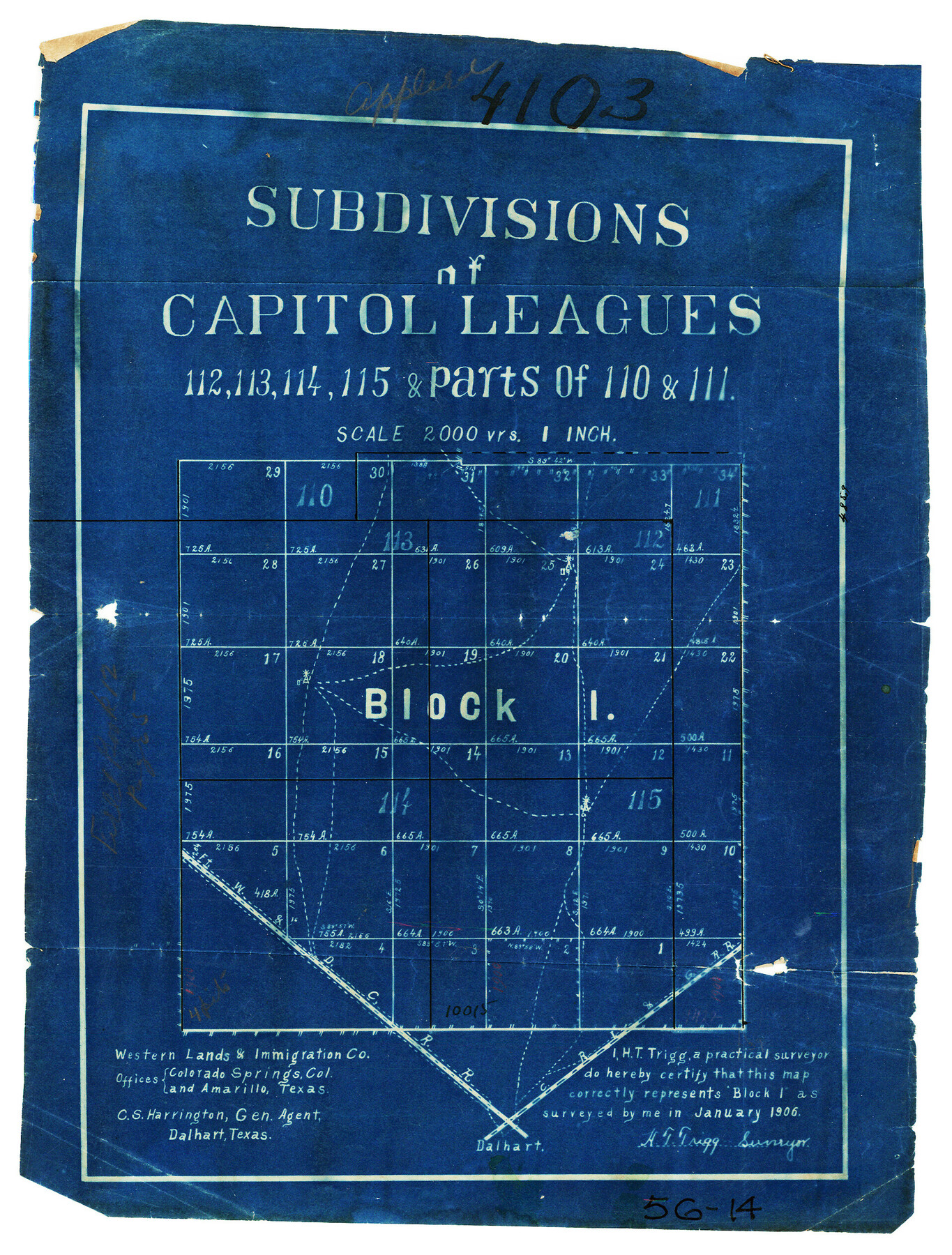
Subdivisions of Capitol Leagues 112, 113, 114, 115, and parts of 110 and 111
56-14
-
Map/Doc
90518
-
Collection
Twichell Survey Records
-
Object Dates
1/1906 (Creation Date)
-
People and Organizations
Howard T. Trigg (Surveyor/Engineer)
-
Counties
Dallam
-
Height x Width
6.3 x 8.3 inches
16.0 x 21.1 cm
Part of: Twichell Survey Records

[Sketch showing G. H.& H. Ry. Co. Blks. 2 and 3, H. & T. C. Ry. Co. Blk. 45 and T. &N. O. Ry. Co. Blk. 5T]
![89679, [Sketch showing G. H.& H. Ry. Co. Blks. 2 and 3, H. & T. C. Ry. Co. Blk. 45 and T. &N. O. Ry. Co. Blk. 5T], Twichell Survey Records](https://historictexasmaps.com/wmedia_w700/maps/89679-1.tif.jpg)
Print $20.00
- Digital $50.00
[Sketch showing G. H.& H. Ry. Co. Blks. 2 and 3, H. & T. C. Ry. Co. Blk. 45 and T. &N. O. Ry. Co. Blk. 5T]
1890
Size 23.6 x 36.8 inches
Map/Doc 89679
[Resurvey of Block 1 - W. H. Godair]
![92898, [Resurvey of Block 1 - W. H. Godair], Twichell Survey Records](https://historictexasmaps.com/wmedia_w700/maps/92898-1.tif.jpg)
Print $20.00
- Digital $50.00
[Resurvey of Block 1 - W. H. Godair]
1923
Size 22.4 x 9.5 inches
Map/Doc 92898
Crane County, Texas

Print $40.00
- Digital $50.00
Crane County, Texas
Size 38.2 x 53.6 inches
Map/Doc 89917
[Gregg County League No. 2 Subdivided and vicinity]
![91567, [Gregg County League No. 2 Subdivided and vicinity], Twichell Survey Records](https://historictexasmaps.com/wmedia_w700/maps/91567-1.tif.jpg)
Print $20.00
- Digital $50.00
[Gregg County League No. 2 Subdivided and vicinity]
Size 17.7 x 16.3 inches
Map/Doc 91567
[Northwest part of the County]
![90841, [Northwest part of the County], Twichell Survey Records](https://historictexasmaps.com/wmedia_w700/maps/90841-2.tif.jpg)
Print $20.00
- Digital $50.00
[Northwest part of the County]
Size 17.9 x 34.9 inches
Map/Doc 90841
[I. & G. N. Block 1, Runnels County School Land and adjacent areas]
![91615, [I. & G. N. Block 1, Runnels County School Land and adjacent areas], Twichell Survey Records](https://historictexasmaps.com/wmedia_w700/maps/91615-1.tif.jpg)
Print $20.00
- Digital $50.00
[I. & G. N. Block 1, Runnels County School Land and adjacent areas]
Size 34.2 x 28.0 inches
Map/Doc 91615
[North/South line through middle of Block K5]
![90600, [North/South line through middle of Block K5], Twichell Survey Records](https://historictexasmaps.com/wmedia_w700/maps/90600-1.tif.jpg)
Print $3.00
- Digital $50.00
[North/South line through middle of Block K5]
Size 6.8 x 16.9 inches
Map/Doc 90600
Liles City, Gaines County, Texas

Print $20.00
- Digital $50.00
Liles City, Gaines County, Texas
Size 21.5 x 23.9 inches
Map/Doc 92683
[H. & G. N. Block B4]
![90275, [H. & G. N. Block B4], Twichell Survey Records](https://historictexasmaps.com/wmedia_w700/maps/90275-1.tif.jpg)
Print $20.00
- Digital $50.00
[H. & G. N. Block B4]
Size 21.4 x 18.2 inches
Map/Doc 90275
[I. & G. N. RR. Co. Blk. 6, Blks M8, M9 and M10]
![90267, [I. & G. N. RR. Co. Blk. 6, Blks M8, M9 and M10], Twichell Survey Records](https://historictexasmaps.com/wmedia_w700/maps/90267-1.tif.jpg)
Print $20.00
- Digital $50.00
[I. & G. N. RR. Co. Blk. 6, Blks M8, M9 and M10]
Size 34.2 x 20.3 inches
Map/Doc 90267
[Surveys Surrounding I. G. Yates S.F. 12394]
![91577, [Surveys Surrounding I. G. Yates S.F. 12394], Twichell Survey Records](https://historictexasmaps.com/wmedia_w700/maps/91577-1.tif.jpg)
Print $20.00
- Digital $50.00
[Surveys Surrounding I. G. Yates S.F. 12394]
Size 18.6 x 7.2 inches
Map/Doc 91577
You may also like
[Surveys in Austin's Colony along the Brazos and Bernard Rivers]
![43, [Surveys in Austin's Colony along the Brazos and Bernard Rivers], General Map Collection](https://historictexasmaps.com/wmedia_w700/maps/43.tif.jpg)
Print $20.00
- Digital $50.00
[Surveys in Austin's Colony along the Brazos and Bernard Rivers]
1835
Size 23.8 x 18.6 inches
Map/Doc 43

Walker County Working Sketch 13

Print $20.00
- Digital $50.00
Walker County Working Sketch 13
1950
Size 18.0 x 16.6 inches
Map/Doc 72293
Travis County Boundary File 2

Print $42.00
- Digital $50.00
Travis County Boundary File 2
Size 9.3 x 7.2 inches
Map/Doc 59406
Hemphill County Working Sketch 35

Print $20.00
- Digital $50.00
Hemphill County Working Sketch 35
1978
Size 35.9 x 44.8 inches
Map/Doc 66130
Jefferson County Working Sketch 42

Print $20.00
- Digital $50.00
Jefferson County Working Sketch 42
1996
Size 31.7 x 47.2 inches
Map/Doc 66586
Clay County Sketch File 1

Print $22.00
- Digital $50.00
Clay County Sketch File 1
1855
Size 8.9 x 7.6 inches
Map/Doc 18386
Denton County Sketch File 25

Print $4.00
- Digital $50.00
Denton County Sketch File 25
1863
Size 8.0 x 7.4 inches
Map/Doc 20752
Township No. 5 South, Range No. 14 West, Indian Meridian, Oklahoma

Print $4.00
- Digital $50.00
Township No. 5 South, Range No. 14 West, Indian Meridian, Oklahoma
1928
Size 18.0 x 22.6 inches
Map/Doc 75141
Ward County Sketch File 11

Print $20.00
- Digital $50.00
Ward County Sketch File 11
1943
Size 17.4 x 20.4 inches
Map/Doc 12600
Flight Mission No. CRK-8P, Frame 97, Refugio County

Print $20.00
- Digital $50.00
Flight Mission No. CRK-8P, Frame 97, Refugio County
1956
Size 18.5 x 22.1 inches
Map/Doc 86958
Wise County Working Sketch 20

Print $20.00
- Digital $50.00
Wise County Working Sketch 20
1979
Size 22.8 x 27.3 inches
Map/Doc 72634