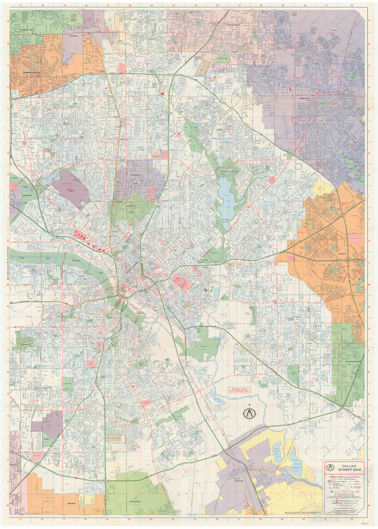
Dallas
[Recto: Dallas Street Map]
-
Map/Doc
94422
-
Collection
General Map Collection
-
People and Organizations
Rand McNally & Co. (Publisher)
-
Counties
Dallas
-
Subjects
City
-
Height x Width
36.3 x 26.0 inches
92.2 x 66.0 cm
-
Medium
paper, etching/engraving/lithograph
-
Scale
1 inch = approx .70 miles
-
Comments
See 94423 for Dallas Street Map and inset maps of Dallas-Ft. Worth and Downtown Dallas on verso.
Related maps

Part of: General Map Collection
Duval County Rolled Sketch 24

Print $20.00
- Digital $50.00
Duval County Rolled Sketch 24
1944
Size 24.5 x 42.3 inches
Map/Doc 5743
Flight Mission No. DCL-7C, Frame 36, Kenedy County

Print $20.00
- Digital $50.00
Flight Mission No. DCL-7C, Frame 36, Kenedy County
1943
Size 18.5 x 22.4 inches
Map/Doc 86024
Camp County Working Sketch 2

Print $20.00
- Digital $50.00
Camp County Working Sketch 2
1975
Size 24.8 x 24.5 inches
Map/Doc 67878

Ector County Working Sketch 24

Print $40.00
- Digital $50.00
Ector County Working Sketch 24
1961
Size 42.2 x 51.7 inches
Map/Doc 68867
Shelby County Sketch File 23

Print $5.00
- Digital $50.00
Shelby County Sketch File 23
Size 16.2 x 7.3 inches
Map/Doc 36645
Flight Mission No. BRA-16M, Frame 97, Jefferson County

Print $20.00
- Digital $50.00
Flight Mission No. BRA-16M, Frame 97, Jefferson County
1953
Size 18.5 x 22.4 inches
Map/Doc 85709
Cottle County Working Sketch 20

Print $20.00
- Digital $50.00
Cottle County Working Sketch 20
1982
Size 19.9 x 37.0 inches
Map/Doc 68330
Hall County Working Sketch Graphic Index

Print $20.00
- Digital $50.00
Hall County Working Sketch Graphic Index
1972
Size 41.7 x 33.7 inches
Map/Doc 76563
Taylor County Working Sketch Graphic Index

Print $20.00
- Digital $50.00
Taylor County Working Sketch Graphic Index
1934
Size 42.8 x 36.4 inches
Map/Doc 76709
Red River County Sketch File 13

Print $4.00
- Digital $50.00
Red River County Sketch File 13
Size 6.9 x 8.2 inches
Map/Doc 35131
Oldham County Working Sketch 3

Print $20.00
- Digital $50.00
Oldham County Working Sketch 3
1946
Size 26.2 x 19.3 inches
Map/Doc 71325
You may also like

[H. &GN Blk. 2, HGN Blk. 1, I, S]
![93212, [H. &GN Blk. 2, HGN Blk. 1, I, S], Twichell Survey Records](https://historictexasmaps.com/wmedia_w700/maps/93212-1.tif.jpg)
Print $40.00
- Digital $50.00
[H. &GN Blk. 2, HGN Blk. 1, I, S]
Size 84.0 x 53.3 inches
Map/Doc 93212
Flight Mission No. BRE-2P, Frame 104, Nueces County

Print $20.00
- Digital $50.00
Flight Mission No. BRE-2P, Frame 104, Nueces County
1956
Size 18.5 x 22.5 inches
Map/Doc 86789
Wichita County Sketch File 1

Print $22.00
- Digital $50.00
Wichita County Sketch File 1
1856
Size 13.5 x 16.8 inches
Map/Doc 40028
Liberty County Sketch File 27

Print $5.00
- Digital $50.00
Liberty County Sketch File 27
Size 11.5 x 9.3 inches
Map/Doc 29948


Erath County Working Sketch 37

Print $20.00
- Digital $50.00
Erath County Working Sketch 37
1973
Size 21.4 x 22.6 inches
Map/Doc 69118
Concho County Sketch File 4

Print $2.00
- Digital $50.00
Concho County Sketch File 4
1858
Size 8.0 x 10.1 inches
Map/Doc 82523
Mason County Working Sketch 8

Print $20.00
- Digital $50.00
Mason County Working Sketch 8
1946
Size 22.9 x 32.3 inches
Map/Doc 70844
Sterling County

Print $20.00
- Digital $50.00
Sterling County
1971
Size 45.6 x 33.9 inches
Map/Doc 95645
Uvalde County Working Sketch 39

Print $20.00
- Digital $50.00
Uvalde County Working Sketch 39
1975
Size 28.0 x 45.3 inches
Map/Doc 72109