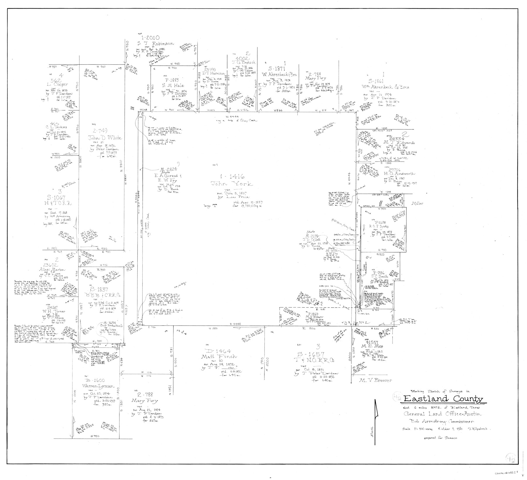
Eastland County Working Sketch 46
-
Map/Doc
68827
-
Collection
General Map Collection
-
Object Dates
10/7/1980 (Creation Date)
-
People and Organizations
Joan Kilpatrick (Draftsman)
-
Counties
Eastland
-
Subjects
Surveying Working Sketch
-
Height x Width
33.4 x 36.6 inches
84.8 x 93.0 cm
-
Scale
1" = 300 varas
Part of: General Map Collection

Railroad Track Map, H&TCRRCo., Falls County, Texas

Print $4.00
- Digital $50.00
Railroad Track Map, H&TCRRCo., Falls County, Texas
1918
Size 11.7 x 18.5 inches
Map/Doc 62858
State Highway System of Texas Showing Condition of Improvement

Print $5.00
- Digital $50.00
State Highway System of Texas Showing Condition of Improvement
1929
Size 28.5 x 30.9 inches
Map/Doc 93720
Calhoun County NRC Article 33.136 Sketch 1

Print $42.00
- Digital $50.00
Calhoun County NRC Article 33.136 Sketch 1
2000
Size 16.8 x 21.7 inches
Map/Doc 61556
Hudspeth County Working Sketch 62

Print $20.00
- Digital $50.00
Hudspeth County Working Sketch 62
1993
Size 23.9 x 32.4 inches
Map/Doc 66347
Reeves County Working Sketch 9

Print $20.00
- Digital $50.00
Reeves County Working Sketch 9
1948
Size 19.0 x 24.0 inches
Map/Doc 63452
Current Miscellaneous File 98

Print $40.00
- Digital $50.00
Current Miscellaneous File 98
Size 18.4 x 26.3 inches
Map/Doc 74338
Baylor County Sketch File 31

Print $6.00
- Digital $50.00
Baylor County Sketch File 31
1880
Size 14.3 x 8.9 inches
Map/Doc 14235
Montague County Rolled Sketch 3

Print $20.00
- Digital $50.00
Montague County Rolled Sketch 3
1940
Size 24.0 x 15.9 inches
Map/Doc 6787
Township 1 South Range 12 West, South Western District, Louisiana

Print $20.00
- Digital $50.00
Township 1 South Range 12 West, South Western District, Louisiana
1884
Size 19.5 x 24.7 inches
Map/Doc 65880
Val Verde County Working Sketch 113

Print $40.00
- Digital $50.00
Val Verde County Working Sketch 113
2003
Size 54.9 x 34.6 inches
Map/Doc 78492
Wichita County Sketch File R

Print $8.00
- Digital $50.00
Wichita County Sketch File R
Size 14.3 x 8.8 inches
Map/Doc 40142
You may also like
Lamar County Boundary File 56a

Print $34.00
- Digital $50.00
Lamar County Boundary File 56a
Size 8.7 x 14.3 inches
Map/Doc 56020
Lamb County Sketch File 12

Print $16.00
- Digital $50.00
Lamb County Sketch File 12
Size 8.6 x 7.7 inches
Map/Doc 29363
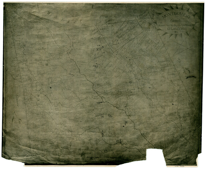
Montgomery County
Print $20.00
- Digital $50.00
Montgomery County
1861
Size 18.5 x 22.6 inches
Map/Doc 78283
[Surveys made in Peters Colony by Thomas Leckie]
![1983, [Surveys made in Peters Colony by Thomas Leckie], General Map Collection](https://historictexasmaps.com/wmedia_w700/maps/1983.tif.jpg)
Print $20.00
- Digital $50.00
[Surveys made in Peters Colony by Thomas Leckie]
1858
Size 22.9 x 16.6 inches
Map/Doc 1983
Titus County Sketch File 1

Print $4.00
- Digital $50.00
Titus County Sketch File 1
Size 13.3 x 8.2 inches
Map/Doc 38130
Archer County Working Sketch 22

Print $20.00
- Digital $50.00
Archer County Working Sketch 22
1980
Size 36.4 x 38.0 inches
Map/Doc 67163
Marion County Working Sketch 3

Print $20.00
- Digital $50.00
Marion County Working Sketch 3
Size 34.9 x 30.0 inches
Map/Doc 70778
[G. C. & S. F. Block S, E. L. & R. R. Block M and B9, D. & W. Block 24]
![91278, [G. C. & S. F. Block S, E. L. & R. R. Block M and B9, D. & W. Block 24], Twichell Survey Records](https://historictexasmaps.com/wmedia_w700/maps/91278-1.tif.jpg)
Print $20.00
- Digital $50.00
[G. C. & S. F. Block S, E. L. & R. R. Block M and B9, D. & W. Block 24]
Size 20.7 x 15.7 inches
Map/Doc 91278
Current Miscellaneous File 62

Print $64.00
- Digital $50.00
Current Miscellaneous File 62
Size 10.1 x 6.9 inches
Map/Doc 74068
Robertson V Ranch

Print $20.00
- Digital $50.00
Robertson V Ranch
Size 41.7 x 46.0 inches
Map/Doc 89756
Fayette County Boundary File 2

Print $53.00
- Digital $50.00
Fayette County Boundary File 2
Size 11.2 x 9.0 inches
Map/Doc 53331
Duval County Sketch File 86

Print $4.00
- Digital $50.00
Duval County Sketch File 86
1934
Size 11.4 x 8.8 inches
Map/Doc 21547