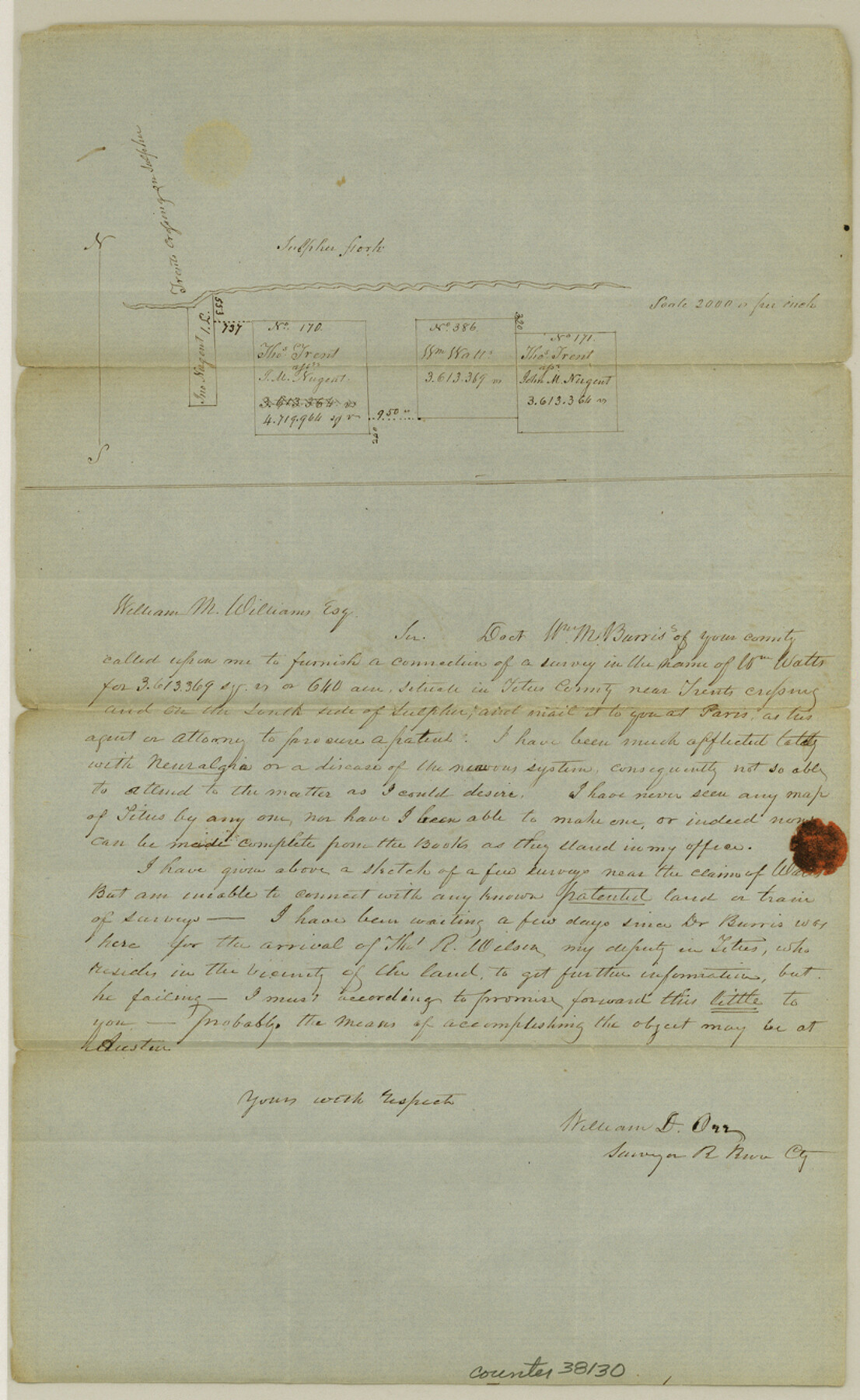
Titus County Sketch File 1
[Sketch of surveys in the northwest corner of the county near Trent's Crossing of the Sulphur River]
-
Map/Doc
38130
-
Collection
General Map Collection
-
Object Dates
1851 (File Date)
-
People and Organizations
William D. Orr (Surveyor/Engineer)
-
Counties
Titus Franklin
-
Subjects
Surveying Sketch File
-
Height x Width
13.3 x 8.2 inches
33.8 x 20.8 cm
-
Medium
paper, manuscript
-
Scale
1" = 2000 varas
-
Features
Sulphur Fork
Trent's Crossing of Sulphur Creek
Part of: General Map Collection
Lampasas County Sketch File 4

Print $4.00
- Digital $50.00
Lampasas County Sketch File 4
1861
Size 12.3 x 8.2 inches
Map/Doc 29394
Liberty County Rolled Sketch E

Print $20.00
- Digital $50.00
Liberty County Rolled Sketch E
Size 20.8 x 31.0 inches
Map/Doc 9439
Reeves County Working Sketch 7

Print $20.00
- Digital $50.00
Reeves County Working Sketch 7
1946
Size 36.7 x 43.9 inches
Map/Doc 63450
Colorado County Sketch File 15

Print $4.00
- Digital $50.00
Colorado County Sketch File 15
Size 13.0 x 8.1 inches
Map/Doc 18943
Henderson County Working Sketch 24

Print $20.00
- Digital $50.00
Henderson County Working Sketch 24
1952
Size 29.3 x 22.9 inches
Map/Doc 66157
Andrews County Rolled Sketch 12B

Print $20.00
- Digital $50.00
Andrews County Rolled Sketch 12B
1933
Size 39.9 x 37.8 inches
Map/Doc 8392
Swisher County Sketch File 8

Print $20.00
- Digital $50.00
Swisher County Sketch File 8
1907
Size 19.2 x 16.3 inches
Map/Doc 12405
Navarro County Working Sketch 16

Print $20.00
- Digital $50.00
Navarro County Working Sketch 16
1993
Size 15.8 x 17.7 inches
Map/Doc 71246
Mason County Boundary File 4

Print $38.00
- Digital $50.00
Mason County Boundary File 4
Size 8.7 x 4.0 inches
Map/Doc 56852
Harrison County

Print $20.00
- Digital $50.00
Harrison County
1857
Size 20.3 x 21.0 inches
Map/Doc 1116
Maverick County Sketch File 11

Print $40.00
- Digital $50.00
Maverick County Sketch File 11
1879
Size 8.3 x 8.8 inches
Map/Doc 31092
Flight Mission No. DAG-22K, Frame 75, Matagorda County

Print $20.00
- Digital $50.00
Flight Mission No. DAG-22K, Frame 75, Matagorda County
1953
Size 18.5 x 22.3 inches
Map/Doc 86462
You may also like
Harris County Sketch File 56a

Print $54.00
- Digital $50.00
Harris County Sketch File 56a
1912
Size 9.0 x 7.9 inches
Map/Doc 25456
Kerr County Working Sketch 7

Print $20.00
- Digital $50.00
Kerr County Working Sketch 7
1947
Size 38.9 x 30.8 inches
Map/Doc 70038
Controlled Mosaic by Jack Amman Photogrammetric Engineers, Inc - Sheet 14

Print $20.00
- Digital $50.00
Controlled Mosaic by Jack Amman Photogrammetric Engineers, Inc - Sheet 14
1954
Size 20.0 x 24.0 inches
Map/Doc 83458
Right of Way & Track Map Houston & Brazos Valley Ry. operated by Houston & Brazos Valley Ry. Co., Hoskins Mound Branch

Print $40.00
- Digital $50.00
Right of Way & Track Map Houston & Brazos Valley Ry. operated by Houston & Brazos Valley Ry. Co., Hoskins Mound Branch
1924
Size 25.0 x 56.7 inches
Map/Doc 66713

Moore County Working Sketch 4

Print $20.00
- Digital $50.00
Moore County Working Sketch 4
1911
Size 20.1 x 15.6 inches
Map/Doc 71186
Randall County Rolled Sketch 8

Print $20.00
- Digital $50.00
Randall County Rolled Sketch 8
Size 32.9 x 40.6 inches
Map/Doc 7429
Rio Grande, Willamar Sheet

Print $20.00
- Digital $50.00
Rio Grande, Willamar Sheet
1937
Size 36.9 x 37.2 inches
Map/Doc 65111
Colorado River, East Bernard Sheet

Print $4.00
- Digital $50.00
Colorado River, East Bernard Sheet
1939
Size 24.3 x 29.9 inches
Map/Doc 65308
Northwest Part Pecos County

Print $20.00
- Digital $50.00
Northwest Part Pecos County
1975
Size 43.4 x 44.2 inches
Map/Doc 95612
Henderson County Working Sketch 12

Print $20.00
- Digital $50.00
Henderson County Working Sketch 12
1915
Size 23.3 x 24.9 inches
Map/Doc 66145
Flight Mission No. DQN-1K, Frame 154, Calhoun County

Print $20.00
- Digital $50.00
Flight Mission No. DQN-1K, Frame 154, Calhoun County
1953
Size 18.7 x 22.4 inches
Map/Doc 84213