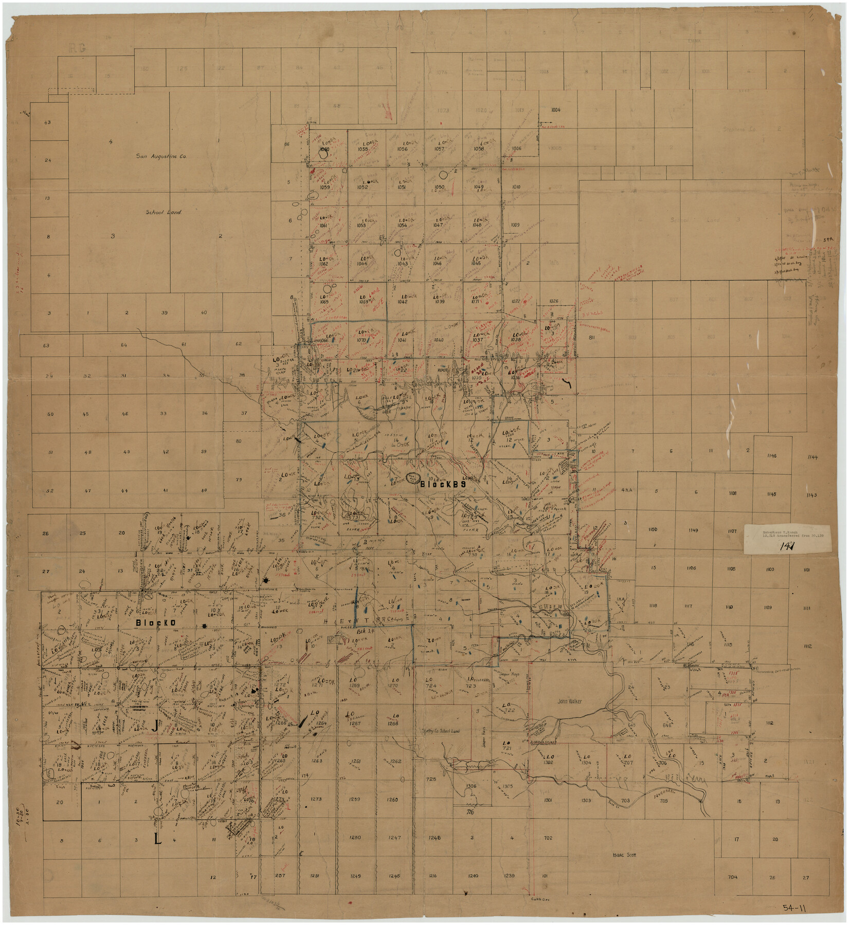
Robertson V Ranch
54-11
-
Map/Doc
89756
-
Collection
Twichell Survey Records
-
Counties
Crosby Lubbock Lynn Garza
-
Height x Width
41.7 x 46.0 inches
105.9 x 116.8 cm
Part of: Twichell Survey Records

[Sketch showing C. D. & W. A. Murphy's Pasture and Wint Barfield's Pasture]
![90885, [Sketch showing C. D. & W. A. Murphy's Pasture and Wint Barfield's Pasture], Twichell Survey Records](https://historictexasmaps.com/wmedia_w700/maps/90885-1.tif.jpg)
Print $20.00
- Digital $50.00
[Sketch showing C. D. & W. A. Murphy's Pasture and Wint Barfield's Pasture]
Size 31.9 x 27.4 inches
Map/Doc 90885
Crane County, Texas

Print $40.00
- Digital $50.00
Crane County, Texas
Size 38.2 x 53.6 inches
Map/Doc 89917
[Southwest part of B. S. & F. Block and surveys to the south]
![90389, [Southwest part of B. S. & F. Block and surveys to the south], Twichell Survey Records](https://historictexasmaps.com/wmedia_w700/maps/90389-1.tif.jpg)
Print $3.00
- Digital $50.00
[Southwest part of B. S. & F. Block and surveys to the south]
Size 11.1 x 10.3 inches
Map/Doc 90389
Blocks 3 and 4 Capitol Syndicate Subdivision of Capitol Leagues 93, 94, 95, 96, 104, 105, 106, 107, 116, 117, 118, 127, 128, 129, 130, 131, 132, 140, 141, 142, and Parts of 75, 83, 84, 85, 86, 108, 143, 144, and 145

Print $20.00
- Digital $50.00
Blocks 3 and 4 Capitol Syndicate Subdivision of Capitol Leagues 93, 94, 95, 96, 104, 105, 106, 107, 116, 117, 118, 127, 128, 129, 130, 131, 132, 140, 141, 142, and Parts of 75, 83, 84, 85, 86, 108, 143, 144, and 145
1906
Size 18.1 x 29.2 inches
Map/Doc 92582
Map of Leagues 245, 246, 247, 250, 251, 252, 253, 254, and 321, Surveys 128, 130, 131, 132, R. E. Montgomery, and Surveys 133 and 134, Block A, Public Free School Land

Print $20.00
- Digital $50.00
Map of Leagues 245, 246, 247, 250, 251, 252, 253, 254, and 321, Surveys 128, 130, 131, 132, R. E. Montgomery, and Surveys 133 and 134, Block A, Public Free School Land
1930
Size 21.8 x 29.4 inches
Map/Doc 91270
Farmer Subdivision of Wm. Baker Survey

Print $20.00
- Digital $50.00
Farmer Subdivision of Wm. Baker Survey
Size 16.1 x 15.5 inches
Map/Doc 90122
Hockley County Sketch, Mineral Application Number 38245

Print $20.00
- Digital $50.00
Hockley County Sketch, Mineral Application Number 38245
Size 27.2 x 10.8 inches
Map/Doc 91093
[T. & P. Block 43, Township 1N]
![90827, [T. & P. Block 43, Township 1N], Twichell Survey Records](https://historictexasmaps.com/wmedia_w700/maps/90827-2.tif.jpg)
Print $20.00
- Digital $50.00
[T. & P. Block 43, Township 1N]
Size 23.0 x 17.8 inches
Map/Doc 90827
[Sketch showing surveys in Blocks 70, 71 and 72 surrounding the town of Toyah]
![91750, [Sketch showing surveys in Blocks 70, 71 and 72 surrounding the town of Toyah], Twichell Survey Records](https://historictexasmaps.com/wmedia_w700/maps/91750-1.tif.jpg)
Print $20.00
- Digital $50.00
[Sketch showing surveys in Blocks 70, 71 and 72 surrounding the town of Toyah]
Size 44.9 x 26.1 inches
Map/Doc 91750
[Texas Boundary Line]
![92069, [Texas Boundary Line], Twichell Survey Records](https://historictexasmaps.com/wmedia_w700/maps/92069-1.tif.jpg)
Print $20.00
- Digital $50.00
[Texas Boundary Line]
Size 31.8 x 18.1 inches
Map/Doc 92069
Tech Memorial Park, Inc. Section Q

Print $20.00
- Digital $50.00
Tech Memorial Park, Inc. Section Q
Size 34.8 x 21.2 inches
Map/Doc 92357
You may also like
Map of Encinal County

Print $20.00
- Digital $50.00
Map of Encinal County
1878
Size 32.8 x 22.7 inches
Map/Doc 3514
Reagan County Boundary File 1a

Print $50.00
- Digital $50.00
Reagan County Boundary File 1a
Size 14.4 x 8.7 inches
Map/Doc 58154
Hardin County Working Sketch 22

Print $20.00
- Digital $50.00
Hardin County Working Sketch 22
1948
Size 20.9 x 31.6 inches
Map/Doc 63420
[Texas Gulf Coast]
![72678, [Texas Gulf Coast], General Map Collection](https://historictexasmaps.com/wmedia_w700/maps/72678.tif.jpg)
Print $20.00
- Digital $50.00
[Texas Gulf Coast]
Size 18.3 x 27.6 inches
Map/Doc 72678
[Galveston, Harrisburg & San Antonio through El Paso County]
![64001, [Galveston, Harrisburg & San Antonio through El Paso County], General Map Collection](https://historictexasmaps.com/wmedia_w700/maps/64001.tif.jpg)
Print $20.00
- Digital $50.00
[Galveston, Harrisburg & San Antonio through El Paso County]
1907
Size 13.6 x 33.7 inches
Map/Doc 64001
Zapata County Rolled Sketch 10A

Print $20.00
- Digital $50.00
Zapata County Rolled Sketch 10A
1912
Size 26.3 x 26.5 inches
Map/Doc 8312
Crockett County Sketch File 4a

Print $20.00
- Digital $50.00
Crockett County Sketch File 4a
Size 28.1 x 8.2 inches
Map/Doc 11215
Fort Bend County State Real Property Sketch 8

Print $40.00
- Digital $50.00
Fort Bend County State Real Property Sketch 8
1985
Size 35.0 x 43.6 inches
Map/Doc 61682
Brazoria County Sketch File 59

Print $364.00
- Digital $50.00
Brazoria County Sketch File 59
1996
Size 14.9 x 8.3 inches
Map/Doc 15398
[San Antonio & Aransas Pass Railway Co.]
![64261, [San Antonio & Aransas Pass Railway Co.], General Map Collection](https://historictexasmaps.com/wmedia_w700/maps/64261.tif.jpg)
Print $20.00
- Digital $50.00
[San Antonio & Aransas Pass Railway Co.]
Size 22.9 x 35.1 inches
Map/Doc 64261
Flight Mission No. DCL-7C, Frame 118, Kenedy County

Print $20.00
- Digital $50.00
Flight Mission No. DCL-7C, Frame 118, Kenedy County
1943
Size 18.4 x 22.3 inches
Map/Doc 86083
Karte von Indian Point od Indianola / Karte der Stadt Neu Braunfels / Karte der Stadt Friedrichsburg / Hafen von Indian Point oder Indianola

Print $20.00
- Digital $50.00
Karte von Indian Point od Indianola / Karte der Stadt Neu Braunfels / Karte der Stadt Friedrichsburg / Hafen von Indian Point oder Indianola
1850
Size 13.6 x 19.4 inches
Map/Doc 2182