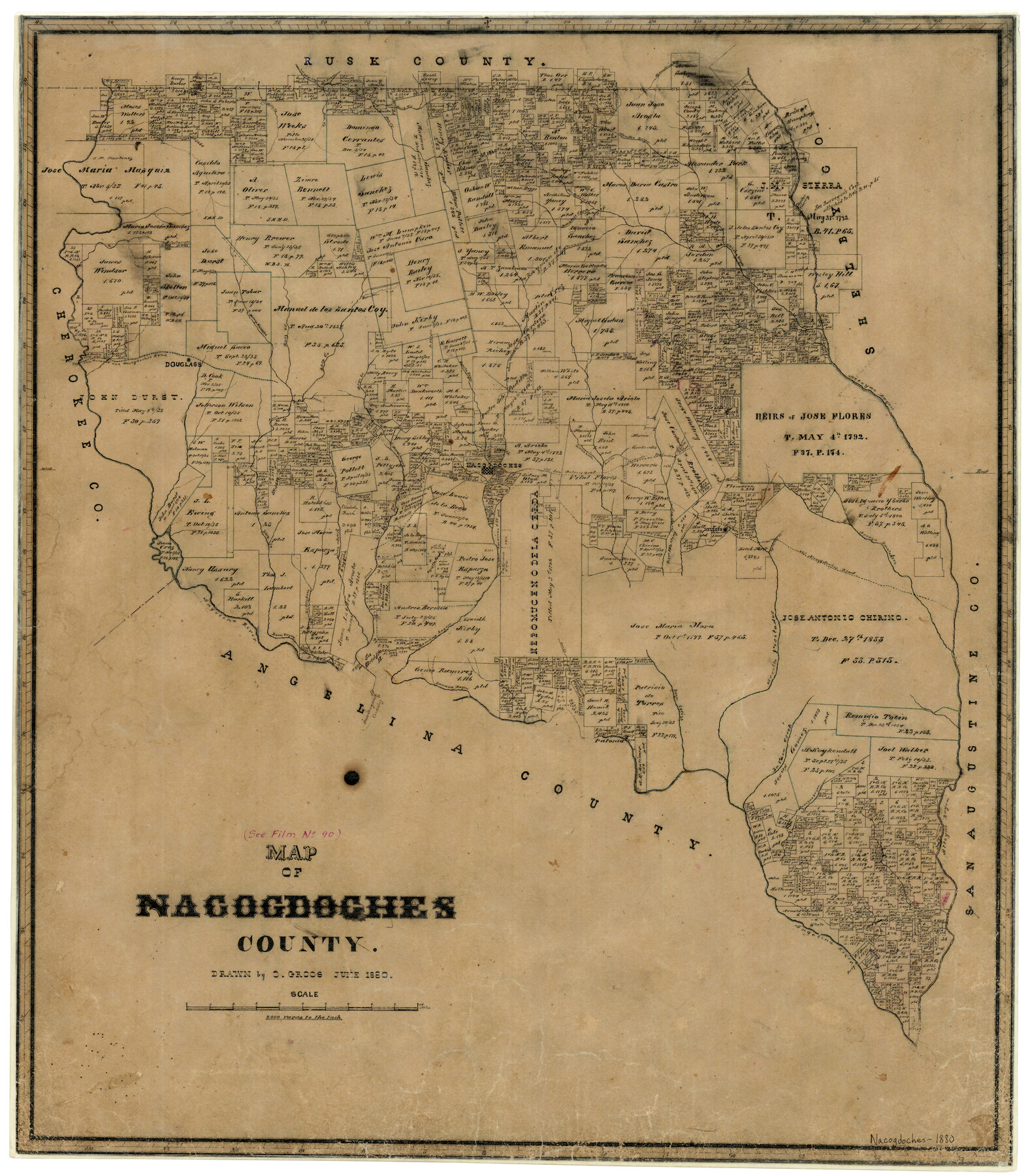
Map of Nacogdoches County
-
Map/Doc
3908
-
Collection
General Map Collection
-
Object Dates
1880 (Creation Date)
-
People and Organizations
Texas General Land Office (Publisher)
Otto Groos (Draftsman)
-
Counties
Nacogdoches
-
Subjects
County
-
Height x Width
23.9 x 20.9 inches
60.7 x 53.1 cm
-
Features
Melrose
Lamand Bayou
Little Loco Creek
Don Joaquin Crossing
Angelina River
Patonia
Carizo Bayou
La Vaca Creek
Attoyac Bayou
Durazno Bayou
Caney Creek
Nacogdoches
Alazan Bayou
Provella Road
Arrollo Visitador
Agorridos Creek
Dorr Creek
Loco Bayou
Nacogdoches Road
Old San Antonio and Nacogdoches Road
Bonita Bayou
Camana Bayou
Miconicho Bayou
Guajalote Creek
John Durst Road
Aguillitas Creek
Sandy Creek
Douglass
Pen Creek
East Fork of Angelina River
Beech Creek
Wandes Bayou
Golondrino Bayou
Aycitos Crossing
Noconicho Bayou
Tellisfore Creek
Clear Creek
Nadundo Creek
Arroyo Nacasote
San Antonio Road
Dills Creek
Loco Creek
Raiz Creek
Rota Creek
Bobija Creek
Moral Bayou
Rusk Creek
Old San Antonio Road
White Oak Creek
Red Creek
Shelbyville Road
Arroyo Amaladero
Old Nacogdoches Road
Part of: General Map Collection
Hunt County Boundary File 6

Print $6.00
- Digital $50.00
Hunt County Boundary File 6
Size 14.3 x 8.6 inches
Map/Doc 55225
Milam County Aerial Photograph Index Sheet 3

Print $20.00
- Digital $50.00
Milam County Aerial Photograph Index Sheet 3
1951
Size 24.3 x 20.4 inches
Map/Doc 86602
Chambers County Sketch File 37

Print $20.00
- Digital $50.00
Chambers County Sketch File 37
Size 25.0 x 43.8 inches
Map/Doc 10333
Fayette County

Print $40.00
- Digital $50.00
Fayette County
1978
Size 42.8 x 54.5 inches
Map/Doc 77278
Flight Mission No. BRA-8M, Frame 121, Jefferson County

Print $20.00
- Digital $50.00
Flight Mission No. BRA-8M, Frame 121, Jefferson County
1953
Size 18.5 x 22.4 inches
Map/Doc 85617
Donley County Working Sketch 3

Print $40.00
- Digital $50.00
Donley County Working Sketch 3
Size 58.7 x 44.8 inches
Map/Doc 68736
Aransas County Sketch File 14

Print $36.00
- Digital $50.00
Aransas County Sketch File 14
1891
Size 14.0 x 8.5 inches
Map/Doc 13128
Edwards County Working Sketch 26

Print $20.00
- Digital $50.00
Edwards County Working Sketch 26
1942
Size 31.8 x 28.8 inches
Map/Doc 68902
Galveston County NRC Article 33.136 Sketch 2

Print $46.00
- Digital $50.00
Galveston County NRC Article 33.136 Sketch 2
2000
Size 23.1 x 34.4 inches
Map/Doc 61565
Tarrant County Working Sketch 6

Print $20.00
- Digital $50.00
Tarrant County Working Sketch 6
1979
Size 29.3 x 18.7 inches
Map/Doc 62423
Dimmit County Rolled Sketch M

Print $20.00
- Digital $50.00
Dimmit County Rolled Sketch M
1936
Size 21.5 x 39.3 inches
Map/Doc 5727
Concho County Working Sketch 2

Print $20.00
- Digital $50.00
Concho County Working Sketch 2
1915
Size 22.4 x 17.6 inches
Map/Doc 68184
You may also like
Cass County Working Sketch 37

Print $20.00
- Digital $50.00
Cass County Working Sketch 37
1982
Size 26.8 x 31.8 inches
Map/Doc 67940
Morris County Rolled Sketch 2A

Print $20.00
- Digital $50.00
Morris County Rolled Sketch 2A
Size 24.4 x 19.3 inches
Map/Doc 10266
F. Z. Bishop's Subdivision of Armstrong's Ranch, Gaines County, Texas

Print $20.00
- Digital $50.00
F. Z. Bishop's Subdivision of Armstrong's Ranch, Gaines County, Texas
1924
Size 22.7 x 21.5 inches
Map/Doc 92653

[Surveys along the Trinity River]
![321, [Surveys along the Trinity River], General Map Collection](https://historictexasmaps.com/wmedia_w700/maps/321.tif.jpg)
Print $2.00
- Digital $50.00
[Surveys along the Trinity River]
Size 3.6 x 3.7 inches
Map/Doc 321
Replat of Baker 2nd Addition to Lamesa, Part of Southwest Quarter, Section 71, Block 35, Dawson County, Texas

Print $20.00
- Digital $50.00
Replat of Baker 2nd Addition to Lamesa, Part of Southwest Quarter, Section 71, Block 35, Dawson County, Texas
1958
Size 9.9 x 18.8 inches
Map/Doc 92633
Crockett County Working Sketch 25

Print $20.00
- Digital $50.00
Crockett County Working Sketch 25
1921
Size 23.5 x 17.6 inches
Map/Doc 68358
Coast Chart No. 210 - Aransas Pass and Corpus Christi Bay with the coast to latitude 27° 12', Texas

Print $20.00
- Digital $50.00
Coast Chart No. 210 - Aransas Pass and Corpus Christi Bay with the coast to latitude 27° 12', Texas
1887
Size 23.4 x 29.4 inches
Map/Doc 73443
Llano County Working Sketch 2

Print $20.00
- Digital $50.00
Llano County Working Sketch 2
1949
Size 21.0 x 24.3 inches
Map/Doc 70620
Flight Mission No. BQR-22K, Frame 45, Brazoria County

Print $20.00
- Digital $50.00
Flight Mission No. BQR-22K, Frame 45, Brazoria County
1953
Size 18.7 x 22.4 inches
Map/Doc 84129
[Surveying Sketch of J.H. Vermillion, S.L. Fite, et al in Zapata County]
![698, [Surveying Sketch of J.H. Vermillion, S.L. Fite, et al in Zapata County], Maddox Collection](https://historictexasmaps.com/wmedia_w700/maps/0698.tif.jpg)
Print $20.00
- Digital $50.00
[Surveying Sketch of J.H. Vermillion, S.L. Fite, et al in Zapata County]
1914
Size 15.6 x 12.1 inches
Map/Doc 698
Map Showing Division Line Between Chapman and Mills' Lands

Print $20.00
- Digital $50.00
Map Showing Division Line Between Chapman and Mills' Lands
Size 32.5 x 31.6 inches
Map/Doc 92848