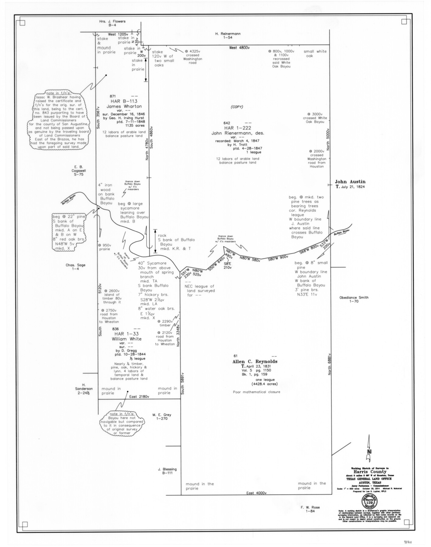
Harris County Working Sketch 129
-
Map/Doc
93711
-
Collection
General Map Collection
-
Object Dates
10/30/2014 (Creation Date)
-
People and Organizations
Michael R. Mokarzel (Draftsman)
Jerry E. Patterson (GLO Commissioner)
-
Counties
Harris
-
Subjects
Surveying Working Sketch
-
Height x Width
24.2 x 19.1 inches
61.5 x 48.5 cm
-
Scale
1" = 600 varas
Part of: General Map Collection
Brewster County Sketch File S-28

Print $40.00
- Digital $50.00
Brewster County Sketch File S-28
Size 26.1 x 36.7 inches
Map/Doc 10982
Aransas County Rolled Sketch 8

Print $20.00
- Digital $50.00
Aransas County Rolled Sketch 8
Size 41.0 x 43.5 inches
Map/Doc 8408
C No. 3 - Sea Coast of Delaware, Maryland, and part of Virginia

Print $20.00
- Digital $50.00
C No. 3 - Sea Coast of Delaware, Maryland, and part of Virginia
1852
Size 30.4 x 22.2 inches
Map/Doc 97207
Edwards County Working Sketch 78

Print $20.00
- Digital $50.00
Edwards County Working Sketch 78
1962
Size 26.5 x 22.1 inches
Map/Doc 68954
Wood County Working Sketch 18

Print $20.00
- Digital $50.00
Wood County Working Sketch 18
1959
Size 31.5 x 27.6 inches
Map/Doc 62018
Sutton County Boundary File 6

Print $10.00
- Digital $50.00
Sutton County Boundary File 6
Size 14.4 x 8.8 inches
Map/Doc 59070
Coleman County Sketch File 45a

Print $4.00
- Digital $50.00
Coleman County Sketch File 45a
1897
Size 9.8 x 6.2 inches
Map/Doc 18791
Franklin County Boundary File 1

Print $8.00
- Digital $50.00
Franklin County Boundary File 1
Size 12.9 x 8.1 inches
Map/Doc 53569
Crosby County Working Sketch 11

Print $20.00
- Digital $50.00
Crosby County Working Sketch 11
1947
Size 23.7 x 22.8 inches
Map/Doc 68445
Tom Green County Working Sketch 5

Print $20.00
- Digital $50.00
Tom Green County Working Sketch 5
1948
Size 34.0 x 40.3 inches
Map/Doc 69374
Map of Cherokee County

Print $40.00
- Digital $50.00
Map of Cherokee County
1933
Size 55.0 x 38.7 inches
Map/Doc 95453
Topographical Map of the Rio Grande, Sheet No. 2

Print $20.00
- Digital $50.00
Topographical Map of the Rio Grande, Sheet No. 2
1912
Map/Doc 89526
You may also like
The Coast & Bays of Western Texas, St. Joseph's and Mustang Islands from actual survey, the remainder from county maps, etc.

Print $20.00
- Digital $50.00
The Coast & Bays of Western Texas, St. Joseph's and Mustang Islands from actual survey, the remainder from county maps, etc.
1857
Size 28.0 x 18.3 inches
Map/Doc 72767
McMullen County Sketch File 8

Print $4.00
- Digital $50.00
McMullen County Sketch File 8
1876
Size 8.6 x 8.8 inches
Map/Doc 31349
Irion County Working Sketch 3

Print $40.00
- Digital $50.00
Irion County Working Sketch 3
1921
Size 16.1 x 49.3 inches
Map/Doc 66412
Navarro County Sketch File 2

Print $4.00
- Digital $50.00
Navarro County Sketch File 2
1857
Size 9.4 x 8.2 inches
Map/Doc 32298
Railroad Commissioner's Map of Texas

Print $20.00
Railroad Commissioner's Map of Texas
1897
Size 27.0 x 23.0 inches
Map/Doc 90070
Oldham County Sketch File 4

Print $20.00
- Digital $50.00
Oldham County Sketch File 4
1883
Size 13.7 x 22.5 inches
Map/Doc 12111
Cass County Rolled Sketch WDC

Print $20.00
- Digital $50.00
Cass County Rolled Sketch WDC
Size 20.8 x 32.9 inches
Map/Doc 5416
[North part] Cass County
![90385, [North part] Cass County, Twichell Survey Records](https://historictexasmaps.com/wmedia_w700/maps/90385-1.tif.jpg)
Print $20.00
- Digital $50.00
[North part] Cass County
1896
Size 37.3 x 19.5 inches
Map/Doc 90385
Texas-Oklahoma Clara Quadrangle

Print $20.00
- Digital $50.00
Texas-Oklahoma Clara Quadrangle
1937
Size 20.3 x 16.9 inches
Map/Doc 75105
Hemphill County Working Sketch 5

Print $20.00
- Digital $50.00
Hemphill County Working Sketch 5
1940
Size 31.6 x 42.4 inches
Map/Doc 66100
Eastland County Working Sketch 53

Print $20.00
- Digital $50.00
Eastland County Working Sketch 53
1982
Size 22.9 x 27.4 inches
Map/Doc 68834
Cameron County

Print $20.00
- Digital $50.00
Cameron County
1976
Size 30.9 x 38.1 inches
Map/Doc 77230