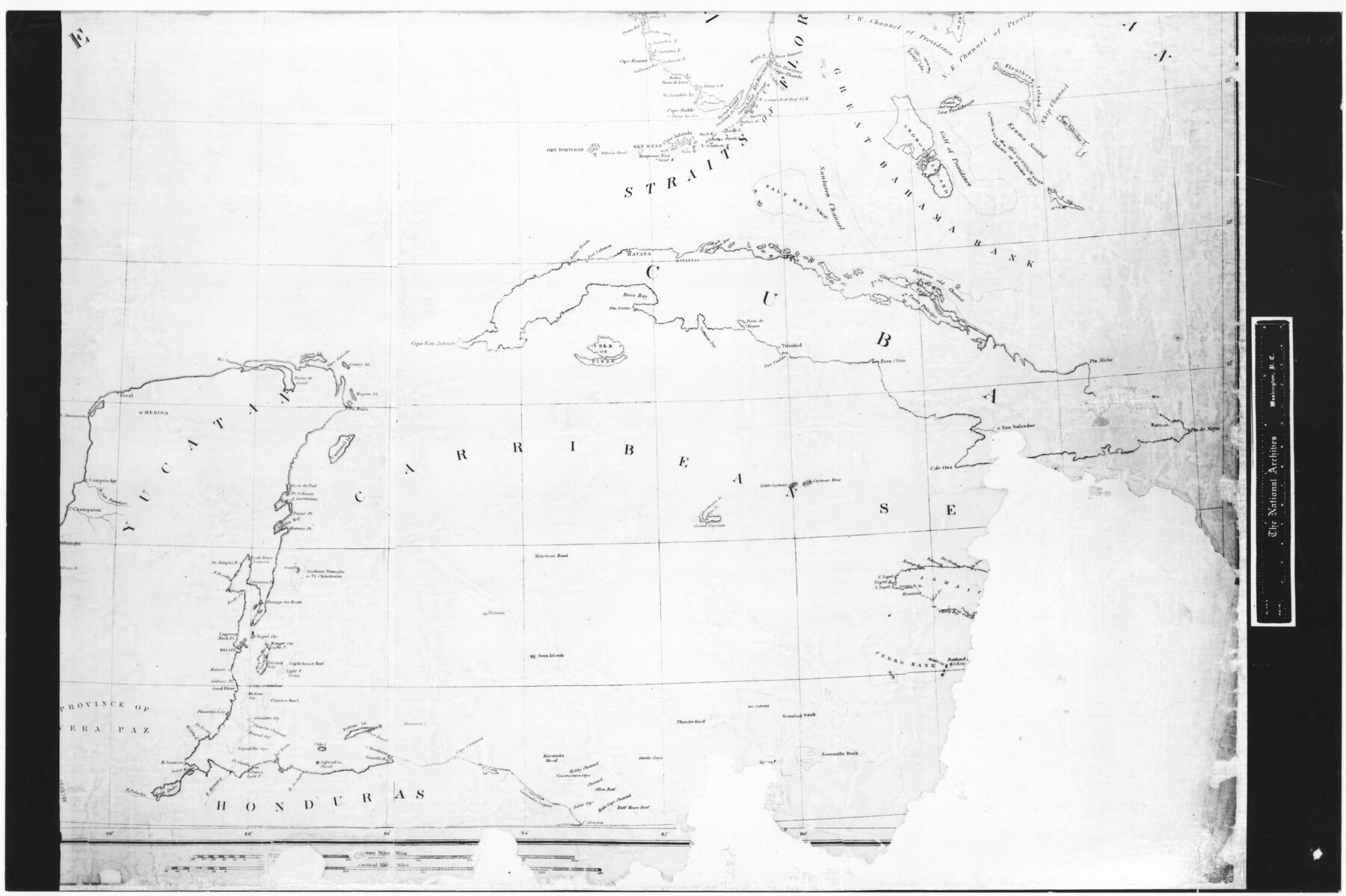
Map of the Straits of Florida and Gulf of Mexico
Map of the Straits of Florida and Gulf of Mexico to accompany a report from the Treasury Department by Israel D. Andrews in obedience to the resolution of the Senate of March 8th, 1851
RL-1-5a
-
Map/Doc
72675
-
Collection
General Map Collection
-
Object Dates
1851/3/8 (Creation Date)
-
People and Organizations
Israel D. Andrews (Author)
-
Subjects
Gulf of Mexico
-
Height x Width
18.3 x 27.4 inches
46.5 x 69.6 cm
-
Comments
B/W photostat copy from National Archives in multiple pieces.
Part of: General Map Collection
[Pacific & Santa Fe Railroad through Fort Stockton]
![64770, [Pacific & Santa Fe Railroad through Fort Stockton], General Map Collection](https://historictexasmaps.com/wmedia_w700/maps/64770.tif.jpg)
Print $20.00
- Digital $50.00
[Pacific & Santa Fe Railroad through Fort Stockton]
Size 18.4 x 20.5 inches
Map/Doc 64770
Johnson County Sketch File 10a

Print $4.00
- Digital $50.00
Johnson County Sketch File 10a
1877
Size 6.7 x 10.6 inches
Map/Doc 28445
Ochiltree County Sketch File 3

Print $40.00
- Digital $50.00
Ochiltree County Sketch File 3
1908
Size 15.4 x 12.9 inches
Map/Doc 33177
Galveston to Rio Grande

Print $20.00
- Digital $50.00
Galveston to Rio Grande
1941
Size 43.7 x 37.1 inches
Map/Doc 69957
Reagan County Rolled Sketch 6

Print $20.00
- Digital $50.00
Reagan County Rolled Sketch 6
Size 17.8 x 17.3 inches
Map/Doc 7435
Childress County Sketch File 19

Print $4.00
- Digital $50.00
Childress County Sketch File 19
Size 14.1 x 8.7 inches
Map/Doc 18294
Nueces County Working Sketch 6

Print $20.00
- Digital $50.00
Nueces County Working Sketch 6
1987
Size 33.7 x 42.9 inches
Map/Doc 71308
Railroad Track Map, H&TCRRCo., Falls County, Texas

Print $4.00
- Digital $50.00
Railroad Track Map, H&TCRRCo., Falls County, Texas
1918
Size 11.7 x 18.5 inches
Map/Doc 62854
Kerr County Working Sketch 22

Print $40.00
- Digital $50.00
Kerr County Working Sketch 22
1965
Size 50.9 x 40.4 inches
Map/Doc 70053
Val Verde County Rolled Sketch 27

Print $20.00
- Digital $50.00
Val Verde County Rolled Sketch 27
Size 26.0 x 37.9 inches
Map/Doc 8109
Flight Mission No. CGI-3N, Frame 141, Cameron County

Print $20.00
- Digital $50.00
Flight Mission No. CGI-3N, Frame 141, Cameron County
1954
Size 18.6 x 22.3 inches
Map/Doc 84614
Hudspeth County Working Sketch 43

Print $40.00
- Digital $50.00
Hudspeth County Working Sketch 43
1981
Size 37.4 x 53.7 inches
Map/Doc 66328
You may also like
Map of Dallas & Wichita Railroad Survey

Print $40.00
- Digital $50.00
Map of Dallas & Wichita Railroad Survey
1874
Size 37.3 x 82.7 inches
Map/Doc 64417
Amistad International Reservoir on Rio Grande 72a

Print $20.00
- Digital $50.00
Amistad International Reservoir on Rio Grande 72a
1949
Size 28.3 x 39.6 inches
Map/Doc 73361
Brewster County Working Sketch 19

Print $20.00
- Digital $50.00
Brewster County Working Sketch 19
1935
Size 15.7 x 13.0 inches
Map/Doc 67551
General Highway Map, Kinney County, Uvalde County, Texas

Print $20.00
General Highway Map, Kinney County, Uvalde County, Texas
1940
Size 18.4 x 24.8 inches
Map/Doc 79162
[Blocks A-10, A-11, and A-12]
![92669, [Blocks A-10, A-11, and A-12], Twichell Survey Records](https://historictexasmaps.com/wmedia_w700/maps/92669-1.tif.jpg)
Print $20.00
- Digital $50.00
[Blocks A-10, A-11, and A-12]
Size 19.7 x 20.0 inches
Map/Doc 92669
Bosque County Sketch File 7

Print $4.00
- Digital $50.00
Bosque County Sketch File 7
1852
Size 12.7 x 7.7 inches
Map/Doc 14750
Hardin County Sketch File 1

Print $8.00
- Digital $50.00
Hardin County Sketch File 1
1851
Size 10.0 x 6.9 inches
Map/Doc 25079
Kinney County Working Sketch 19

Print $20.00
- Digital $50.00
Kinney County Working Sketch 19
1948
Size 32.0 x 35.7 inches
Map/Doc 70201
Jackson County Rolled Sketch 12

Print $20.00
- Digital $50.00
Jackson County Rolled Sketch 12
1956
Size 23.9 x 32.7 inches
Map/Doc 6344
Stephens County Sketch File 15

Print $4.00
- Digital $50.00
Stephens County Sketch File 15
1890
Size 9.1 x 6.7 inches
Map/Doc 37068
Harris County Rolled Sketch 63

Print $40.00
- Digital $50.00
Harris County Rolled Sketch 63
1936
Size 41.4 x 52.5 inches
Map/Doc 9120
Sutton County Working Sketch 25

Print $40.00
- Digital $50.00
Sutton County Working Sketch 25
Size 69.4 x 37.1 inches
Map/Doc 62368