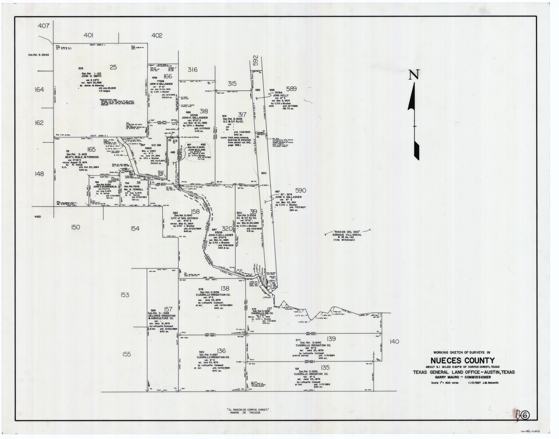
Nueces County Working Sketch 6
-
Map/Doc
71308
-
Collection
General Map Collection
-
Object Dates
11/3/1987 (Creation Date)
-
People and Organizations
James M. Naismith (Draftsman)
-
Counties
Nueces
-
Subjects
Surveying Working Sketch
-
Height x Width
33.7 x 42.9 inches
85.6 x 109.0 cm
-
Scale
1" = 400 varas
Part of: General Map Collection
Map of Fort Bend Co.

Print $20.00
- Digital $50.00
Map of Fort Bend Co.
1898
Size 45.1 x 41.1 inches
Map/Doc 75965
Reeves County Sketch File 9

Print $20.00
- Digital $50.00
Reeves County Sketch File 9
Size 46.3 x 38.2 inches
Map/Doc 10587
Val Verde County Sketch File A

Print $20.00
- Digital $50.00
Val Verde County Sketch File A
1878
Size 25.6 x 16.0 inches
Map/Doc 12538
Stonewall County Rolled Sketch 15

Print $20.00
- Digital $50.00
Stonewall County Rolled Sketch 15
1902
Size 39.2 x 28.0 inches
Map/Doc 7870
Galveston Harbor and Channel, Texas - Rehabilitation of Galveston Groins - Location Plan of Rehabilitation

Print $4.00
- Digital $50.00
Galveston Harbor and Channel, Texas - Rehabilitation of Galveston Groins - Location Plan of Rehabilitation
1968
Size 19.7 x 21.5 inches
Map/Doc 73627
Galveston County Rolled Sketch 46

Print $40.00
- Digital $50.00
Galveston County Rolled Sketch 46
2000
Size 32.0 x 48.3 inches
Map/Doc 5981
Burnet County Sketch File 19

Print $4.00
- Digital $50.00
Burnet County Sketch File 19
1859
Size 11.6 x 8.2 inches
Map/Doc 16710
Rand McNally Standard Map of Texas

Rand McNally Standard Map of Texas
1930
Size 34.6 x 28.0 inches
Map/Doc 2147
Chart showing the relative positions of the lights in the Eighth Light House District extending from Cedar Keys, Florida to Rio Grande, Texas

Print $20.00
- Digital $50.00
Chart showing the relative positions of the lights in the Eighth Light House District extending from Cedar Keys, Florida to Rio Grande, Texas
1876
Size 24.7 x 18.2 inches
Map/Doc 72680

Cass County Working Sketch 1

Print $20.00
- Digital $50.00
Cass County Working Sketch 1
Size 20.2 x 21.9 inches
Map/Doc 67904
Duval County Rolled Sketch 26

Print $20.00
- Digital $50.00
Duval County Rolled Sketch 26
1945
Size 21.2 x 20.0 inches
Map/Doc 5744
You may also like
[Abstract Numbering Register - Donley through Karnes]
![82966, [Abstract Numbering Register - Donley through Karnes], General Map Collection](https://historictexasmaps.com/wmedia_w700/pdf_converted_jpg/qi_pdf_thumbnail_30613.jpg)
[Abstract Numbering Register - Donley through Karnes]
Map/Doc 82966
General Highway Map. Detail of Cities and Towns in Galveston County, Texas. City Map of Galveston and vicinity, Galveston County, Texas

Print $20.00
General Highway Map. Detail of Cities and Towns in Galveston County, Texas. City Map of Galveston and vicinity, Galveston County, Texas
1961
Size 18.1 x 24.6 inches
Map/Doc 79477
Gillespie County Rolled Sketch 3

Print $20.00
- Digital $50.00
Gillespie County Rolled Sketch 3
Size 19.0 x 28.1 inches
Map/Doc 6010
Bell County Working Sketch 13

Print $20.00
- Digital $50.00
Bell County Working Sketch 13
1964
Size 19.6 x 18.5 inches
Map/Doc 67353
Liberty County Sketch File 24

Print $6.00
- Digital $50.00
Liberty County Sketch File 24
Size 10.2 x 7.9 inches
Map/Doc 29936
Gillespie County Boundary File 7a

Print $40.00
- Digital $50.00
Gillespie County Boundary File 7a
Size 8.7 x 51.2 inches
Map/Doc 53780
Edwards County Rolled Sketch 31

Print $20.00
- Digital $50.00
Edwards County Rolled Sketch 31
1982
Size 30.5 x 39.4 inches
Map/Doc 8849
Trinity River, Ferris Sheet/Ten Mile Creek

Print $4.00
- Digital $50.00
Trinity River, Ferris Sheet/Ten Mile Creek
1935
Size 20.1 x 25.1 inches
Map/Doc 65242
The Republic County of Milam. January 15, 1842

Print $20.00
The Republic County of Milam. January 15, 1842
2020
Size 17.4 x 21.6 inches
Map/Doc 96230
Atascosa County Sketch File 28

Print $40.00
- Digital $50.00
Atascosa County Sketch File 28
1878
Size 27.9 x 21.7 inches
Map/Doc 10862
Crockett County Rolled Sketch 83

Print $20.00
- Digital $50.00
Crockett County Rolled Sketch 83
1960
Size 22.6 x 15.2 inches
Map/Doc 5623
Brewster County Rolled Sketch 24C

Print $20.00
- Digital $50.00
Brewster County Rolled Sketch 24C
Size 17.5 x 20.8 inches
Map/Doc 5210