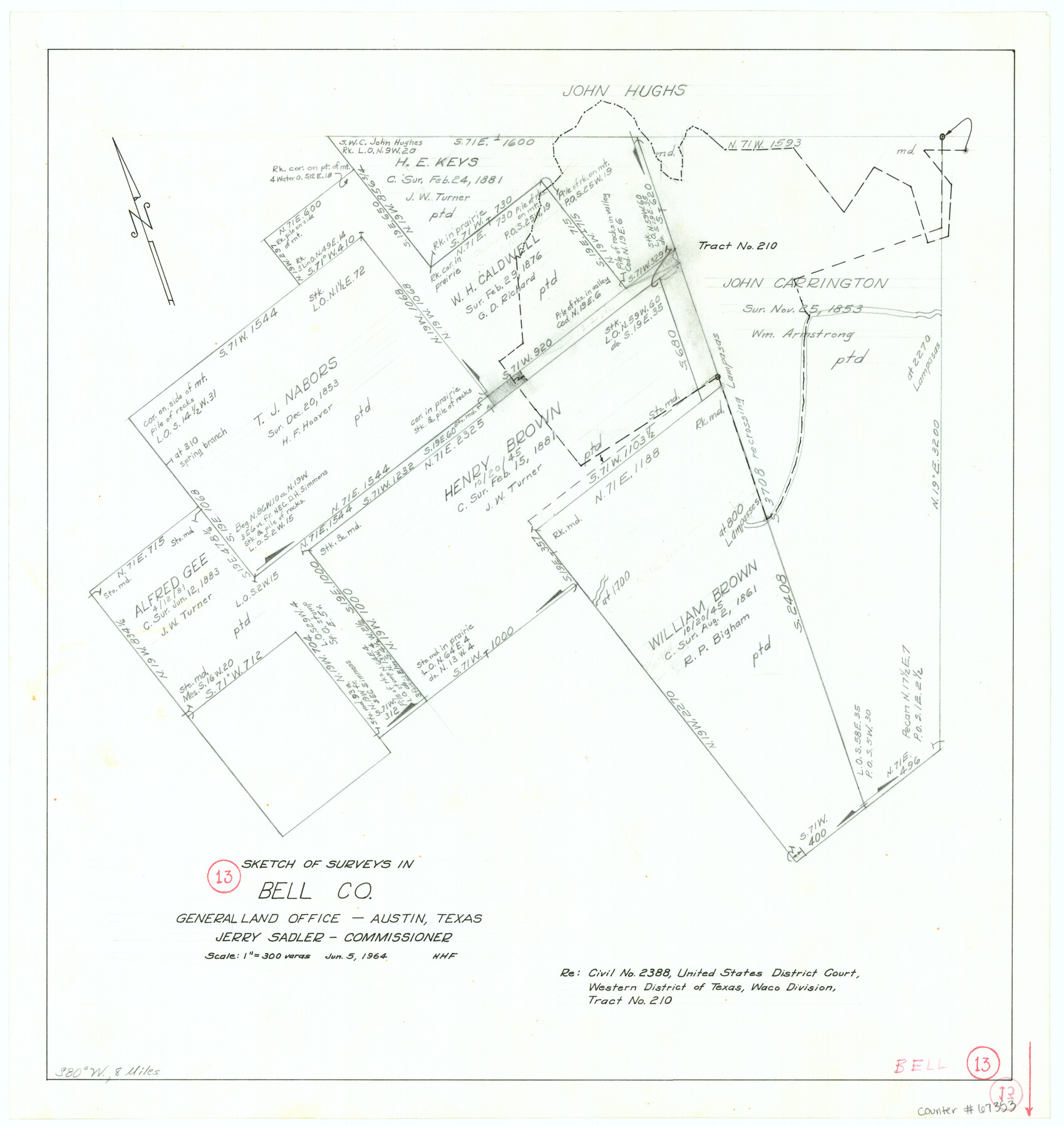
Bell County Working Sketch 13
-
Map/Doc
67353
-
Collection
General Map Collection
-
Object Dates
6/5/1964 (Creation Date)
-
People and Organizations
Herman H. Forbes (Draftsman)
Jerry Sadler (GLO Commissioner)
-
Counties
Bell
-
Subjects
Surveying Working Sketch
-
Height x Width
19.6 x 18.5 inches
49.8 x 47.0 cm
-
Scale
1" = 300 varas
-
Comments
Surveys located about eight miles South 80 degrees West of Belton, Texas.
Part of: General Map Collection
Southern Part of Laguna Madre

Print $20.00
- Digital $50.00
Southern Part of Laguna Madre
1987
Size 44.5 x 34.7 inches
Map/Doc 73548
Baylor County Aerial Photograph Index Sheet 2

Print $20.00
- Digital $50.00
Baylor County Aerial Photograph Index Sheet 2
1950
Size 22.2 x 15.4 inches
Map/Doc 83664
Outer Continental Shelf Leasing Maps (Louisiana Offshore Operations)

Print $20.00
- Digital $50.00
Outer Continental Shelf Leasing Maps (Louisiana Offshore Operations)
1959
Size 18.3 x 14.5 inches
Map/Doc 76112
Flight Mission No. DIX-5P, Frame 138, Aransas County

Print $20.00
- Digital $50.00
Flight Mission No. DIX-5P, Frame 138, Aransas County
1956
Size 17.7 x 17.9 inches
Map/Doc 83799
Wilbarger County Sketch File 17

Print $4.00
- Digital $50.00
Wilbarger County Sketch File 17
1886
Size 14.2 x 8.7 inches
Map/Doc 40207
Carson County Boundary File 4

Print $4.00
- Digital $50.00
Carson County Boundary File 4
Size 9.6 x 6.2 inches
Map/Doc 51132
Old Miscellaneous File 28

Print $6.00
- Digital $50.00
Old Miscellaneous File 28
1838
Size 10.2 x 8.4 inches
Map/Doc 75736
Refugio County Working Sketch 18

Print $20.00
- Digital $50.00
Refugio County Working Sketch 18
2013
Size 24.0 x 29.3 inches
Map/Doc 93622
Harris County Working Sketch 88

Print $20.00
- Digital $50.00
Harris County Working Sketch 88
1972
Size 30.3 x 38.4 inches
Map/Doc 65980
Flight Mission No. DQO-3K, Frame 28, Galveston County

Print $20.00
- Digital $50.00
Flight Mission No. DQO-3K, Frame 28, Galveston County
1952
Size 18.1 x 22.3 inches
Map/Doc 85069
Pecos County Working Sketch 107

Print $40.00
- Digital $50.00
Pecos County Working Sketch 107
1971
Size 55.3 x 37.4 inches
Map/Doc 71580
Fisher County Sketch File A

Print $20.00
- Digital $50.00
Fisher County Sketch File A
1901
Size 33.1 x 22.8 inches
Map/Doc 11482
You may also like

Maps of Gulf Intracoastal Waterway, Texas - Sabine River to the Rio Grande and connecting waterways including ship channels

Print $20.00
- Digital $50.00
Maps of Gulf Intracoastal Waterway, Texas - Sabine River to the Rio Grande and connecting waterways including ship channels
1966
Size 14.5 x 22.2 inches
Map/Doc 61915
Dimmit County Working Sketch 31

Print $20.00
- Digital $50.00
Dimmit County Working Sketch 31
1959
Size 26.3 x 42.8 inches
Map/Doc 68692

Atascosa County Working Sketch 21

Print $20.00
- Digital $50.00
Atascosa County Working Sketch 21
1954
Size 26.0 x 22.4 inches
Map/Doc 67217
Val Verde County Working Sketch 93

Print $20.00
- Digital $50.00
Val Verde County Working Sketch 93
1976
Size 40.9 x 40.6 inches
Map/Doc 72228
Crockett County Working Sketch 71

Print $20.00
- Digital $50.00
Crockett County Working Sketch 71
1963
Size 38.7 x 32.7 inches
Map/Doc 68404
Wilson Empresario Colony. May 27, 1826

Print $20.00
Wilson Empresario Colony. May 27, 1826
2020
Size 19.4 x 21.6 inches
Map/Doc 96010
Oil Development and Structural Map showing Schott, Mirando and other oil fields of the Laredo District with present and proposed development.

Print $20.00
- Digital $50.00
Oil Development and Structural Map showing Schott, Mirando and other oil fields of the Laredo District with present and proposed development.
1920
Size 11.3 x 8.9 inches
Map/Doc 94107
The Republic County of Bexar. December 29, 1845

Print $20.00
The Republic County of Bexar. December 29, 1845
2020
Size 24.6 x 21.6 inches
Map/Doc 96101
Garza County Sketch File 11

Print $4.00
- Digital $50.00
Garza County Sketch File 11
1901
Size 11.3 x 8.8 inches
Map/Doc 24066
Johnson County Working Sketch 14

Print $20.00
- Digital $50.00
Johnson County Working Sketch 14
1974
Size 37.3 x 31.7 inches
Map/Doc 66627