Wilbarger County Sketch File 17
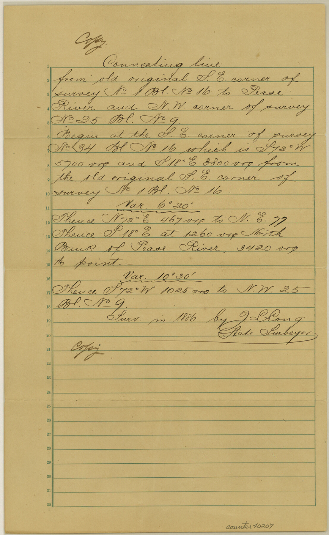
[Field notes of a connecting line from the old original southeast corner of survey 1, Block 16 to Pease River and northwest corner of survey 25, Block 9]
-
Map/Doc
40207
-
Collection
General Map Collection
-
Object Dates
1886 (Creation Date)
-
People and Organizations
J.L. Long (Surveyor/Engineer)
-
Counties
Wilbarger
-
Subjects
Surveying Sketch File
-
Height x Width
14.2 x 8.7 inches
36.1 x 22.1 cm
-
Medium
paper, manuscript
-
Features
Pease River
Part of: General Map Collection
Reeves County Rolled Sketch 25

Print $20.00
- Digital $50.00
Reeves County Rolled Sketch 25
1982
Size 22.3 x 20.6 inches
Map/Doc 7494
Moore County Working Sketch 2

Print $20.00
- Digital $50.00
Moore County Working Sketch 2
1934
Size 18.3 x 41.3 inches
Map/Doc 71184
Val Verde County Rolled Sketch 57

Print $40.00
- Digital $50.00
Val Verde County Rolled Sketch 57
1947
Size 53.6 x 48.9 inches
Map/Doc 10077
Bexar County Sketch File 36d

Print $40.00
- Digital $50.00
Bexar County Sketch File 36d
1878
Size 21.1 x 26.0 inches
Map/Doc 10923
Map of Kendall County

Print $20.00
- Digital $50.00
Map of Kendall County
1862
Size 21.0 x 20.0 inches
Map/Doc 3754
Hidalgo County Sketch File 14

Print $20.00
- Digital $50.00
Hidalgo County Sketch File 14
Size 29.6 x 24.5 inches
Map/Doc 11764
Map of a part of Fisher and Miller's Colony - Harvey's District

Print $20.00
- Digital $50.00
Map of a part of Fisher and Miller's Colony - Harvey's District
1856
Size 19.0 x 24.7 inches
Map/Doc 4657
Flight Mission No. BRA-16M, Frame 173, Jefferson County

Print $20.00
- Digital $50.00
Flight Mission No. BRA-16M, Frame 173, Jefferson County
1953
Size 18.5 x 22.2 inches
Map/Doc 85771
Culberson County Working Sketch 24

Print $20.00
- Digital $50.00
Culberson County Working Sketch 24
1947
Size 36.8 x 36.2 inches
Map/Doc 68477
Midland County Working Sketch 23

Print $40.00
- Digital $50.00
Midland County Working Sketch 23
1956
Size 45.0 x 75.6 inches
Map/Doc 71004
Howard County Sketch File 7

Print $20.00
- Digital $50.00
Howard County Sketch File 7
Size 21.7 x 13.8 inches
Map/Doc 11795
Titus County Working Sketch 3

Print $20.00
- Digital $50.00
Titus County Working Sketch 3
Size 21.7 x 31.8 inches
Map/Doc 69364
You may also like
Flight Mission No. DQO-7K, Frame 77, Galveston County

Print $20.00
- Digital $50.00
Flight Mission No. DQO-7K, Frame 77, Galveston County
1952
Size 18.9 x 22.6 inches
Map/Doc 85104
Flight Mission No. DQN-1K, Frame 157, Calhoun County

Print $20.00
- Digital $50.00
Flight Mission No. DQN-1K, Frame 157, Calhoun County
1953
Size 18.4 x 22.2 inches
Map/Doc 84216

Hudspeth County Rolled Sketch 69

Print $20.00
- Digital $50.00
Hudspeth County Rolled Sketch 69
1973
Size 13.3 x 20.5 inches
Map/Doc 7716
Hamilton County Sketch File 23

Print $20.00
- Digital $50.00
Hamilton County Sketch File 23
1955
Size 25.8 x 24.8 inches
Map/Doc 11618
Edwards County Working Sketch 2

Print $20.00
- Digital $50.00
Edwards County Working Sketch 2
Size 13.6 x 19.0 inches
Map/Doc 68878
Harris County Rolled Sketch 97

Print $20.00
- Digital $50.00
Harris County Rolled Sketch 97
Size 18.8 x 23.6 inches
Map/Doc 6135
Flight Mission No. BRA-9M, Frame 69, Jefferson County

Print $20.00
- Digital $50.00
Flight Mission No. BRA-9M, Frame 69, Jefferson County
1953
Size 18.5 x 22.3 inches
Map/Doc 85652
Val Verde County Rolled Sketch 72

Print $20.00
- Digital $50.00
Val Verde County Rolled Sketch 72
Size 15.2 x 28.5 inches
Map/Doc 8134
Stremme General Land Office Drawings, side view

Print $20.00
Stremme General Land Office Drawings, side view
Size 27.0 x 21.8 inches
Map/Doc 79739
Edwards County Working Sketch 37

Print $20.00
- Digital $50.00
Edwards County Working Sketch 37
1948
Size 23.1 x 35.5 inches
Map/Doc 68913
Irion County Sketch File 6

Print $20.00
- Digital $50.00
Irion County Sketch File 6
1900
Size 19.1 x 27.8 inches
Map/Doc 11824