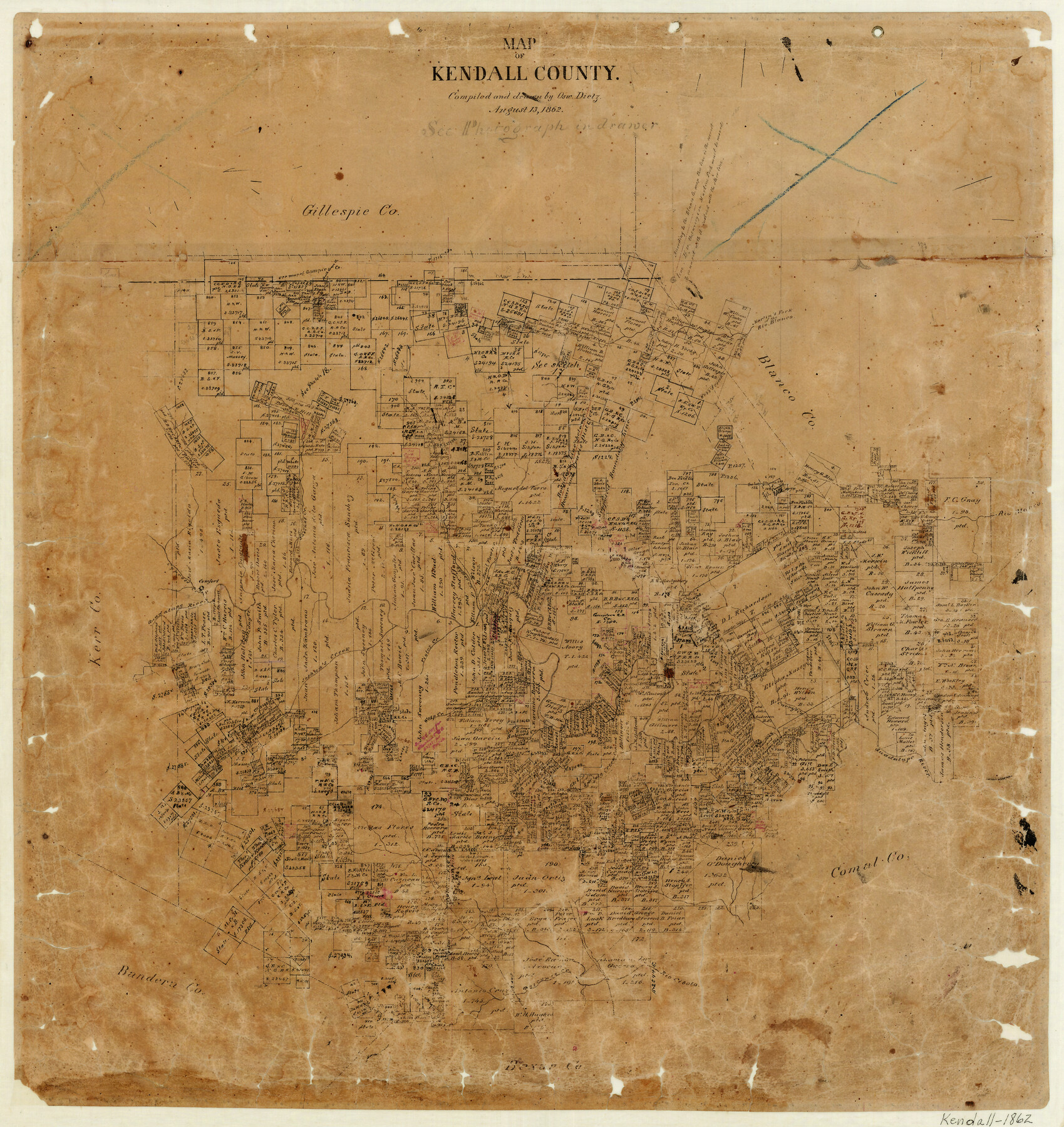
Map of Kendall County
-
Map/Doc
3754
-
Collection
General Map Collection
-
Object Dates
8/13/1862 (Creation Date)
-
People and Organizations
Osw. Dietz (Draftsman)
-
Counties
Kendall
-
Subjects
County
-
Height x Width
21.0 x 20.0 inches
53.3 x 50.8 cm
-
Features
Joshua's Creek
Twin Sisters
Rio Cibolo
Balcones Creek
Wasp Creek
Spring Creek
Curry's Creek
Oyster Creek
Violet Creek
South Grape Creek
Holliday Creek
Comfort
Cypress Creek
Quadalupe [sic] River
Sabinas Creek
Rio Blanco
Martin's Fork of Rio Blanco
Webb's Creek
Part of: General Map Collection
Travis County Working Sketch 44

Print $20.00
- Digital $50.00
Travis County Working Sketch 44
1974
Size 22.3 x 26.4 inches
Map/Doc 69428
Angelina County Sketch File 15g

Print $4.00
- Digital $50.00
Angelina County Sketch File 15g
1882
Size 10.9 x 8.4 inches
Map/Doc 12996
Castro County Rolled Sketch 14

Print $20.00
- Digital $50.00
Castro County Rolled Sketch 14
1965
Size 47.6 x 43.5 inches
Map/Doc 8608
Presidio County Rolled Sketch 133

Print $20.00
- Digital $50.00
Presidio County Rolled Sketch 133
Size 37.3 x 27.2 inches
Map/Doc 7400
Bell County, Milam District

Print $20.00
- Digital $50.00
Bell County, Milam District
1877
Size 23.5 x 28.6 inches
Map/Doc 3293
Photo Index of Texas Coast - Sheet 1 of 6

Print $20.00
- Digital $50.00
Photo Index of Texas Coast - Sheet 1 of 6
1954
Size 20.0 x 24.0 inches
Map/Doc 83438
San Luis Pass to East Matagorda Bay

Print $20.00
- Digital $50.00
San Luis Pass to East Matagorda Bay
1960
Size 34.6 x 46.5 inches
Map/Doc 69963
Hudspeth County Working Sketch 27

Print $40.00
- Digital $50.00
Hudspeth County Working Sketch 27
1972
Size 31.0 x 51.2 inches
Map/Doc 66309
Right of Way and Track Map, Dayton-Goose Creek Ry. Co., Station 0+00 to Station 190+00

Print $40.00
- Digital $50.00
Right of Way and Track Map, Dayton-Goose Creek Ry. Co., Station 0+00 to Station 190+00
1917
Size 24.8 x 56.6 inches
Map/Doc 64365
Red River County Working Sketch 9

Print $20.00
- Digital $50.00
Red River County Working Sketch 9
1920
Size 15.2 x 18.9 inches
Map/Doc 71992
Flight Mission No. BQR-20K, Frame 9, Brazoria County

Print $20.00
- Digital $50.00
Flight Mission No. BQR-20K, Frame 9, Brazoria County
1952
Size 18.6 x 22.4 inches
Map/Doc 84111
Uvalde County Working Sketch 17

Print $20.00
- Digital $50.00
Uvalde County Working Sketch 17
1947
Size 27.5 x 37.3 inches
Map/Doc 72087
You may also like
Victoria County Sketch File 2

Print $7.00
- Digital $50.00
Victoria County Sketch File 2
1873
Size 10.3 x 8.4 inches
Map/Doc 39511
Borden County Boundary File 4

Print $2.00
- Digital $50.00
Borden County Boundary File 4
Size 13.3 x 8.3 inches
Map/Doc 50636
Map of Sabine County

Print $20.00
- Digital $50.00
Map of Sabine County
1896
Size 25.8 x 17.9 inches
Map/Doc 63012
Wichita County Working Sketch 20

Print $20.00
- Digital $50.00
Wichita County Working Sketch 20
1950
Size 33.2 x 23.0 inches
Map/Doc 72530
Smith County Sketch File 2

Print $4.00
- Digital $50.00
Smith County Sketch File 2
1853
Size 12.7 x 8.5 inches
Map/Doc 36748

Goliad County Sketch File 18

Print $100.00
- Digital $50.00
Goliad County Sketch File 18
1854
Size 12.8 x 15.5 inches
Map/Doc 24255
Bandera County Working Sketch 9

Print $20.00
- Digital $50.00
Bandera County Working Sketch 9
1920
Size 15.2 x 17.1 inches
Map/Doc 67602

Comanche County Working Sketch 15

Print $20.00
- Digital $50.00
Comanche County Working Sketch 15
1964
Size 20.3 x 25.5 inches
Map/Doc 68149
Concho County Sketch File 33a

Print $22.00
- Digital $50.00
Concho County Sketch File 33a
Size 21.4 x 19.4 inches
Map/Doc 11159
Webb County Sketch File 48

Print $20.00
- Digital $50.00
Webb County Sketch File 48
1939
Size 17.9 x 26.7 inches
Map/Doc 12646