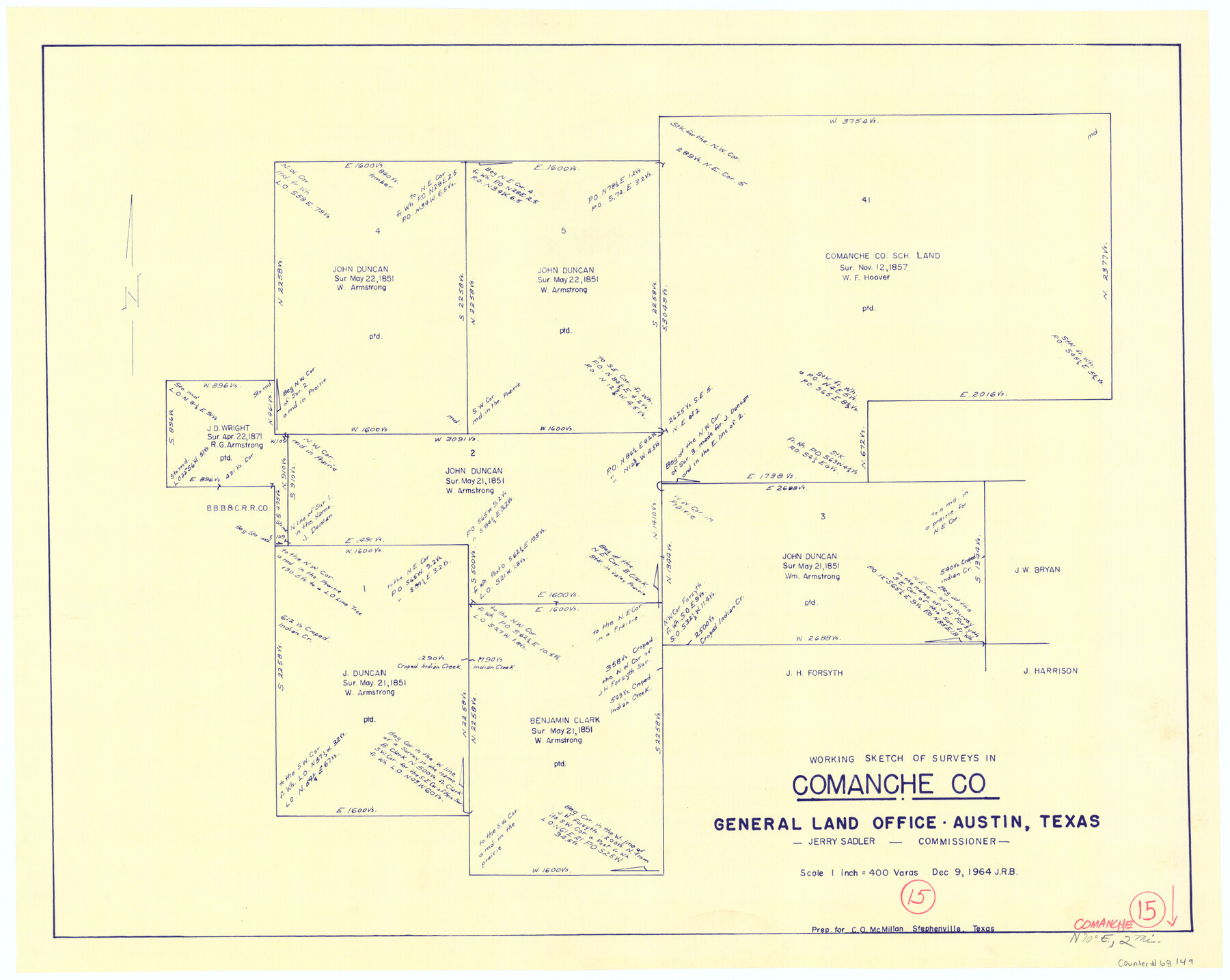
Comanche County Working Sketch 15
-
Map/Doc
68149
-
Collection
General Map Collection
-
Object Dates
12/9/1964 (Creation Date)
-
Counties
Comanche
-
Subjects
Surveying Working Sketch
-
Height x Width
20.3 x 25.5 inches
51.6 x 64.8 cm
-
Scale
1" = 400 varas
Part of: General Map Collection
Tom Green County Sketch File 79A

Print $4.00
- Digital $50.00
Tom Green County Sketch File 79A
1970
Size 14.5 x 8.8 inches
Map/Doc 38258
Cooke County Boundary File 2

Print $19.00
- Digital $50.00
Cooke County Boundary File 2
Size 12.1 x 7.6 inches
Map/Doc 51840
United States

Print $40.00
- Digital $50.00
United States
1961
Size 55.0 x 81.2 inches
Map/Doc 75922
Uvalde County Working Sketch Graphic Index

Print $20.00
- Digital $50.00
Uvalde County Working Sketch Graphic Index
1976
Size 42.5 x 46.2 inches
Map/Doc 76723
Gregg County Boundary File 6a

Print $46.00
- Digital $50.00
Gregg County Boundary File 6a
Size 12.7 x 8.2 inches
Map/Doc 54004
Sutton County Sketch File 2

Print $4.00
- Digital $50.00
Sutton County Sketch File 2
1898
Size 6.1 x 9.7 inches
Map/Doc 37351
Hunt County Sketch File 17

Print $8.00
- Digital $50.00
Hunt County Sketch File 17
1861
Size 10.6 x 8.2 inches
Map/Doc 27114
Houston County Sketch File 41

Print $6.00
- Digital $50.00
Houston County Sketch File 41
1845
Size 16.0 x 10.2 inches
Map/Doc 26828
Wise County Sketch File 2a

Print $4.00
- Digital $50.00
Wise County Sketch File 2a
1856
Size 12.3 x 8.1 inches
Map/Doc 40526
Wichita County Sketch File 12a

Print $10.00
- Digital $50.00
Wichita County Sketch File 12a
1881
Size 14.2 x 8.6 inches
Map/Doc 40077
Stonewall County Boundary File 4a

Print $18.00
- Digital $50.00
Stonewall County Boundary File 4a
Size 14.2 x 8.8 inches
Map/Doc 58984
Orange County Sketch File 10

Print $4.00
- Digital $50.00
Orange County Sketch File 10
1876
Size 8.4 x 12.8 inches
Map/Doc 33317
You may also like
Flight Mission No. DIX-5P, Frame 138, Aransas County

Print $20.00
- Digital $50.00
Flight Mission No. DIX-5P, Frame 138, Aransas County
1956
Size 17.7 x 17.9 inches
Map/Doc 83799
Working Sketch Carson County

Print $3.00
- Digital $50.00
Working Sketch Carson County
1907
Size 11.6 x 17.8 inches
Map/Doc 90224
Crockett County Rolled Sketch 29

Print $20.00
- Digital $50.00
Crockett County Rolled Sketch 29
1927
Size 21.9 x 36.6 inches
Map/Doc 5588
Greater Fort Worth New City Map

Print $20.00
Greater Fort Worth New City Map
1925
Size 33.5 x 22.6 inches
Map/Doc 76286
A General Map of the Middle British Colonies, in America. containing Virginia, Maryland, the Delaware Counties, Pennsylvania and New Jersey. With the addition of New York and of the Greatest Part of New England

Print $20.00
- Digital $50.00
A General Map of the Middle British Colonies, in America. containing Virginia, Maryland, the Delaware Counties, Pennsylvania and New Jersey. With the addition of New York and of the Greatest Part of New England
1776
Size 21.6 x 27.2 inches
Map/Doc 97402
[PSL Block B-19]
![89811, [PSL Block B-19], Twichell Survey Records](https://historictexasmaps.com/wmedia_w700/maps/89811-1.tif.jpg)
Print $40.00
- Digital $50.00
[PSL Block B-19]
Size 43.7 x 56.6 inches
Map/Doc 89811
[Capitol Leagues 217-228, 238, and vicinity]
![90695, [Capitol Leagues 217-228, 238, and vicinity], Twichell Survey Records](https://historictexasmaps.com/wmedia_w700/maps/90695-1.tif.jpg)
Print $20.00
- Digital $50.00
[Capitol Leagues 217-228, 238, and vicinity]
Size 23.8 x 12.9 inches
Map/Doc 90695
Hill County Sketch File 22a

Print $6.00
- Digital $50.00
Hill County Sketch File 22a
1861
Size 11.3 x 9.0 inches
Map/Doc 26509
[Maps of surveys in Reeves & Culberson Cos]
![61146, [Maps of surveys in Reeves & Culberson Cos], General Map Collection](https://historictexasmaps.com/wmedia_w700/maps/61146.tif.jpg)
Print $20.00
- Digital $50.00
[Maps of surveys in Reeves & Culberson Cos]
1937
Size 30.8 x 24.9 inches
Map/Doc 61146
Denton County Sketch File 36a

Print $6.00
- Digital $50.00
Denton County Sketch File 36a
1898
Size 11.3 x 9.1 inches
Map/Doc 20773
Jim Hogg Co. / Brooks Co.

Print $20.00
- Digital $50.00
Jim Hogg Co. / Brooks Co.
1912
Size 33.0 x 43.6 inches
Map/Doc 4894
New Map of the Mining Regions of Idaho and Montana showing the geographical positions of the Blackfoot, Owyhee & South Boise Mines and the various routes thereto

Print $20.00
- Digital $50.00
New Map of the Mining Regions of Idaho and Montana showing the geographical positions of the Blackfoot, Owyhee & South Boise Mines and the various routes thereto
Size 21.9 x 29.4 inches
Map/Doc 93991