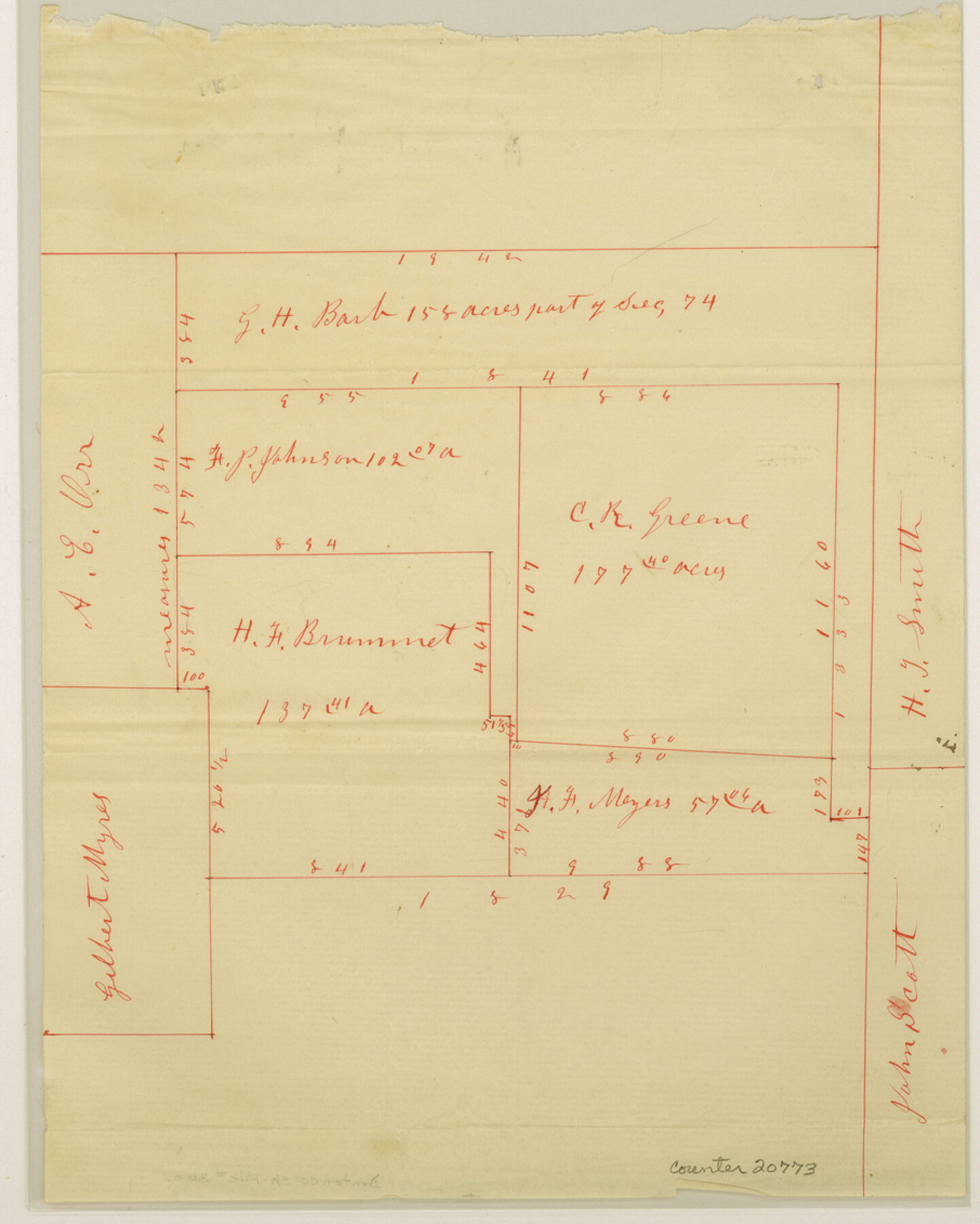
Denton County Sketch File 36a
[Sketch and explanation regarding School Land section 74]
-
Map/Doc
20773
-
Collection
General Map Collection
-
Object Dates
1898/1/25 (Creation Date)
1898/1/26 (File Date)
-
People and Organizations
Elijah Biggerstaff (Surveyor/Engineer)
-
Counties
Denton
-
Subjects
Surveying Sketch File
-
Height x Width
11.3 x 9.1 inches
28.7 x 23.1 cm
-
Medium
paper, manuscript
Part of: General Map Collection
Comanche County Working Sketch 15

Print $20.00
- Digital $50.00
Comanche County Working Sketch 15
1964
Size 20.3 x 25.5 inches
Map/Doc 68149
Gillespie County Rolled Sketch 3

Print $20.00
- Digital $50.00
Gillespie County Rolled Sketch 3
Size 19.0 x 28.1 inches
Map/Doc 6010
Eastland County Working Sketch 18

Print $20.00
- Digital $50.00
Eastland County Working Sketch 18
1919
Size 15.9 x 15.7 inches
Map/Doc 68799
Matagorda Bay Including Lavaca and Tres Palacios Bays

Print $40.00
- Digital $50.00
Matagorda Bay Including Lavaca and Tres Palacios Bays
1973
Size 37.0 x 48.4 inches
Map/Doc 73363
Orange County Sketch File 13

Print $6.00
- Digital $50.00
Orange County Sketch File 13
1885
Size 11.3 x 9.7 inches
Map/Doc 33326
Flight Mission No. BQR-5K, Frame 67, Brazoria County

Print $20.00
- Digital $50.00
Flight Mission No. BQR-5K, Frame 67, Brazoria County
1952
Size 18.7 x 22.5 inches
Map/Doc 84012
[Surveys in Milam's Colony along the Colorado River, Onion Creek, Cedar Creek, and north of the San Antonio Road]
![88, [Surveys in Milam's Colony along the Colorado River, Onion Creek, Cedar Creek, and north of the San Antonio Road], General Map Collection](https://historictexasmaps.com/wmedia_w700/maps/88-1.tif.jpg)
Print $20.00
- Digital $50.00
[Surveys in Milam's Colony along the Colorado River, Onion Creek, Cedar Creek, and north of the San Antonio Road]
Size 13.4 x 26.8 inches
Map/Doc 88
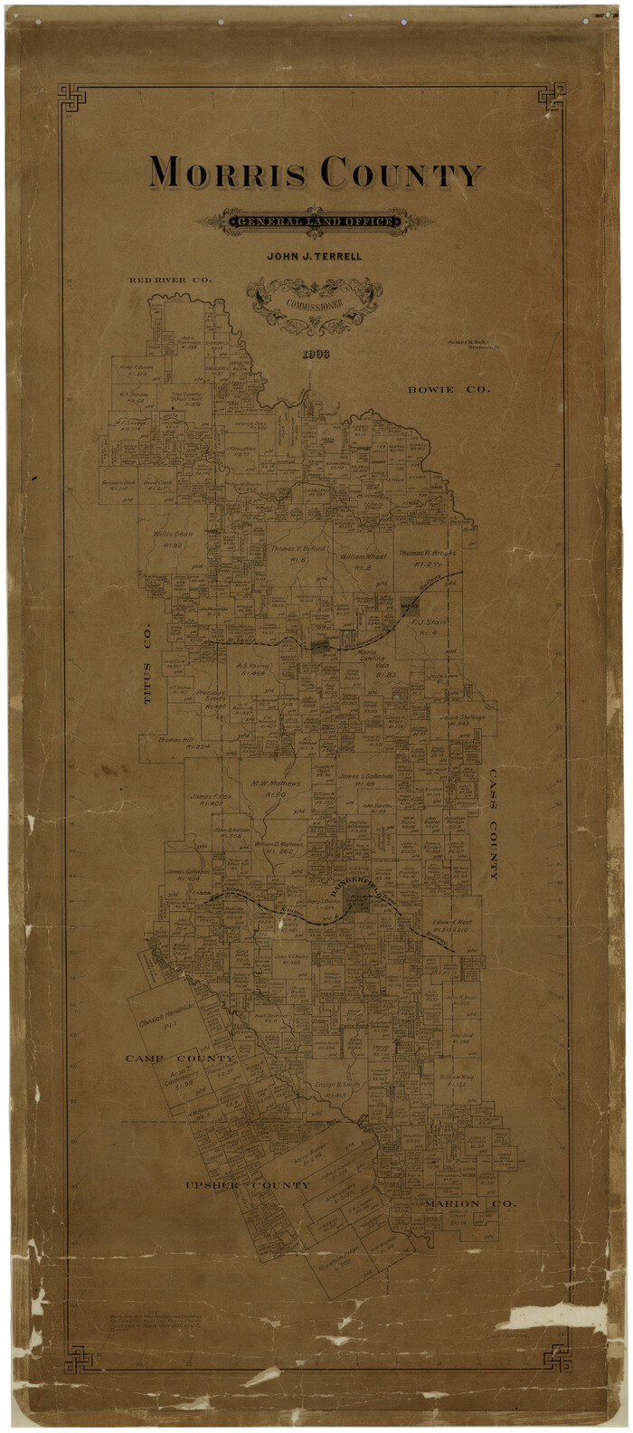
Morris County
Print $40.00
- Digital $50.00
Morris County
1906
Size 54.6 x 24.2 inches
Map/Doc 77094
United States - Gulf Coast - Galveston to Rio Grande

Print $20.00
- Digital $50.00
United States - Gulf Coast - Galveston to Rio Grande
1919
Size 27.1 x 18.3 inches
Map/Doc 72745
Hunt County Rolled Sketch 4

Print $209.00
- Digital $50.00
Hunt County Rolled Sketch 4
1959
Size 10.4 x 15.2 inches
Map/Doc 45992
Part of Laguna Madre in Cameron County, showing Subdivision for Mineral Development

Print $20.00
- Digital $50.00
Part of Laguna Madre in Cameron County, showing Subdivision for Mineral Development
1963
Size 45.8 x 36.0 inches
Map/Doc 1926
Wood County Sketch File 15

Print $5.00
- Digital $50.00
Wood County Sketch File 15
1835
Size 11.0 x 16.3 inches
Map/Doc 40694
You may also like
Crockett County Working Sketch 49

Print $20.00
- Digital $50.00
Crockett County Working Sketch 49
1938
Size 46.7 x 43.9 inches
Map/Doc 68382
Anderson County Sketch File 18

Print $40.00
- Digital $50.00
Anderson County Sketch File 18
1880
Size 16.0 x 13.5 inches
Map/Doc 10801
Uvalde County Rolled Sketch 15

Print $20.00
- Digital $50.00
Uvalde County Rolled Sketch 15
1979
Size 26.9 x 23.9 inches
Map/Doc 8099
Kaufman County Boundary File 3a

Print $28.00
- Digital $50.00
Kaufman County Boundary File 3a
Size 14.2 x 8.6 inches
Map/Doc 55929
McMullen County Sketch File 28

Print $20.00
- Digital $50.00
McMullen County Sketch File 28
1884
Size 24.8 x 28.1 inches
Map/Doc 12061
Potter County Sketch File 2

Print $20.00
- Digital $50.00
Potter County Sketch File 2
1887
Size 29.3 x 39.4 inches
Map/Doc 10573
Hamilton County Sketch File 8

Print $4.00
- Digital $50.00
Hamilton County Sketch File 8
1860
Size 12.2 x 8.0 inches
Map/Doc 24914
Maps of Gulf Intracoastal Waterway, Texas - Sabine River to the Rio Grande and connecting waterways including ship channels

Print $20.00
- Digital $50.00
Maps of Gulf Intracoastal Waterway, Texas - Sabine River to the Rio Grande and connecting waterways including ship channels
1966
Size 14.6 x 20.7 inches
Map/Doc 61999
Shelby County Working Sketch 23a

Print $20.00
- Digital $50.00
Shelby County Working Sketch 23a
1983
Size 28.1 x 31.0 inches
Map/Doc 63876
[Sketch Showing Blocks O18 and B11]
![93108, [Sketch Showing Blocks O18 and B11], Twichell Survey Records](https://historictexasmaps.com/wmedia_w700/maps/93108-1.tif.jpg)
Print $3.00
- Digital $50.00
[Sketch Showing Blocks O18 and B11]
Size 15.5 x 11.9 inches
Map/Doc 93108
Frio County Rolled Sketch 3

Print $20.00
- Digital $50.00
Frio County Rolled Sketch 3
Size 30.7 x 20.1 inches
Map/Doc 5916
Map of the Straits of Florida and Gulf of Mexico

Print $20.00
- Digital $50.00
Map of the Straits of Florida and Gulf of Mexico
1851
Size 18.3 x 27.5 inches
Map/Doc 72673