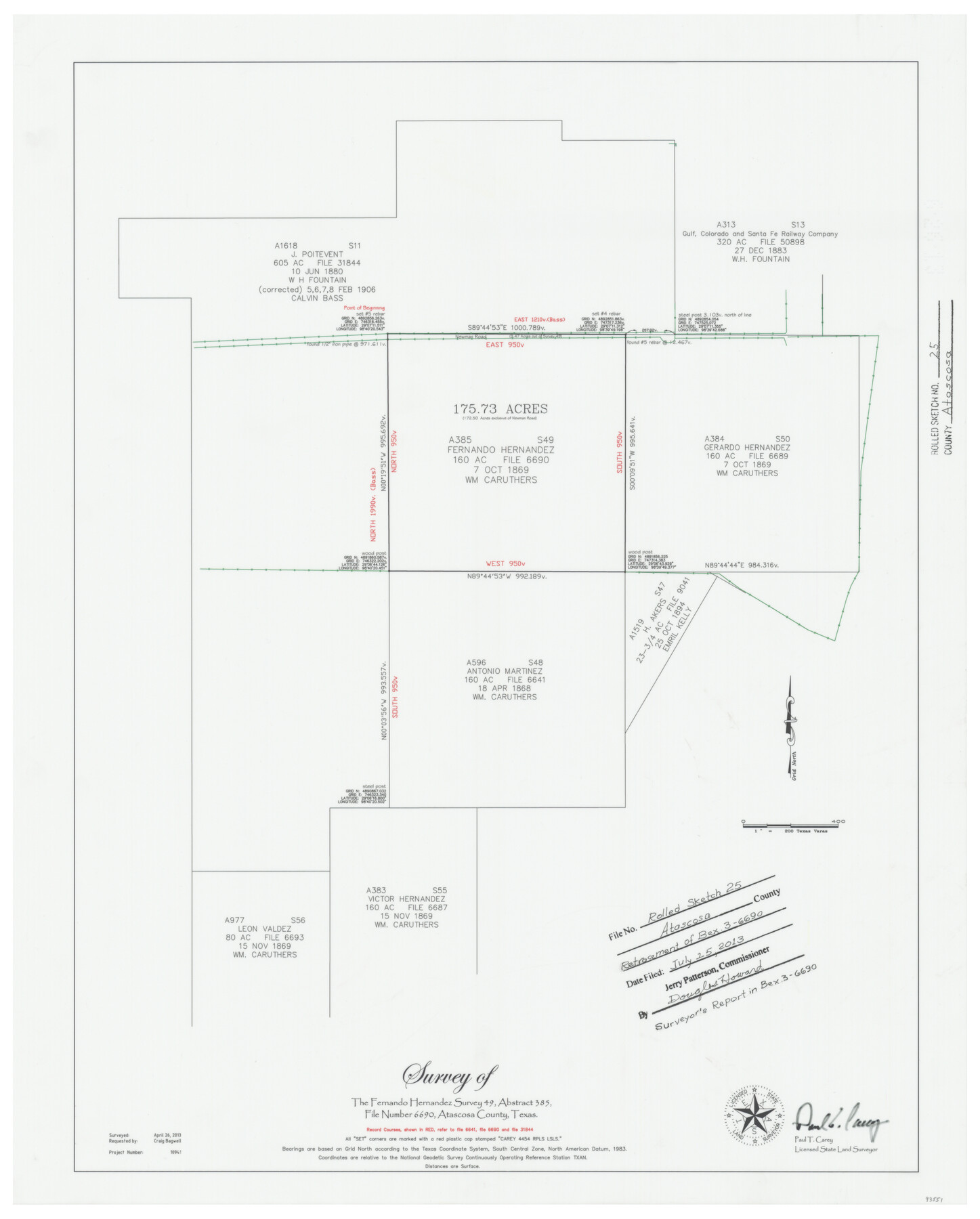
Atascosa County Rolled Sketch 25
Survey of the Fernando Hernandez survey 49, abstract 385
-
Map/Doc
93551
-
Collection
General Map Collection
-
Object Dates
2013/4/26 (Survey Date)
2013/7/15 (File Date)
-
People and Organizations
Paul T. Carey (Surveyor/Engineer)
-
Counties
Atascosa
-
Subjects
Surveying Rolled Sketch
-
Height x Width
25.2 x 20.5 inches
64.0 x 52.1 cm
-
Medium
mylar, print
-
Scale
1" = 200 varas
-
Comments
See surveyor's report in BEX-3-6690
Part of: General Map Collection
Stonewall County Rolled Sketch 10

Print $20.00
- Digital $50.00
Stonewall County Rolled Sketch 10
Size 22.3 x 29.6 inches
Map/Doc 7866
Cass County Rolled Sketch WDC

Print $20.00
- Digital $50.00
Cass County Rolled Sketch WDC
Size 20.8 x 32.9 inches
Map/Doc 5416
Cooke County Sketch File 41

Print $36.00
- Digital $50.00
Cooke County Sketch File 41
1928
Size 11.3 x 8.9 inches
Map/Doc 19308
Shelby County Rolled Sketch 3

Print $40.00
- Digital $50.00
Shelby County Rolled Sketch 3
Size 54.2 x 37.0 inches
Map/Doc 9919
Crockett County Rolled Sketch Z

Print $20.00
- Digital $50.00
Crockett County Rolled Sketch Z
Size 38.7 x 36.1 inches
Map/Doc 76182
Map of Kent County, 1889

Print $20.00
- Digital $50.00
Map of Kent County, 1889
1889
Size 27.2 x 20.2 inches
Map/Doc 3756
Brazos River, Brazos River Sheet 3

Print $6.00
- Digital $50.00
Brazos River, Brazos River Sheet 3
1926
Size 21.8 x 34.6 inches
Map/Doc 65296
Uvalde County Rolled Sketch 10

Print $20.00
- Digital $50.00
Uvalde County Rolled Sketch 10
Size 23.5 x 16.1 inches
Map/Doc 8095
San Patricio County Rolled Sketch 46C

Print $3.00
- Digital $50.00
San Patricio County Rolled Sketch 46C
1983
Size 11.0 x 17.5 inches
Map/Doc 8374
Sterling County Sketch File D

Print $8.00
- Digital $50.00
Sterling County Sketch File D
Size 11.2 x 8.6 inches
Map/Doc 37157
Bee County Sketch File 10

Print $4.00
- Digital $50.00
Bee County Sketch File 10
Size 12.8 x 7.9 inches
Map/Doc 14291
Bee County Working Sketch 31

Print $20.00
- Digital $50.00
Bee County Working Sketch 31
1929
Size 13.5 x 25.1 inches
Map/Doc 67282
You may also like
Map of Gillespie County

Print $20.00
- Digital $50.00
Map of Gillespie County
1857
Size 35.1 x 26.2 inches
Map/Doc 3582
Flight Mission No. DQN-2K, Frame 156, Calhoun County

Print $20.00
- Digital $50.00
Flight Mission No. DQN-2K, Frame 156, Calhoun County
1953
Size 18.5 x 22.3 inches
Map/Doc 84318
Galveston County Rolled Sketch 19

Print $20.00
- Digital $50.00
Galveston County Rolled Sketch 19
Size 21.4 x 28.1 inches
Map/Doc 5957
Davis Mountains State Park Area Showing Scenic Drive

Print $20.00
Davis Mountains State Park Area Showing Scenic Drive
1935
Size 26.9 x 34.5 inches
Map/Doc 76312
Titus County Sketch File 14

Print $4.00
- Digital $50.00
Titus County Sketch File 14
Size 9.7 x 8.3 inches
Map/Doc 38157
Map of the Mirror's Addition to the town of Amarillo, Potter County, Texas on the line of the Fort Worth and Denver City Ry.

Print $20.00
- Digital $50.00
Map of the Mirror's Addition to the town of Amarillo, Potter County, Texas on the line of the Fort Worth and Denver City Ry.
Size 13.3 x 20.1 inches
Map/Doc 91787
Brewster County Sketch File 22

Print $15.00
- Digital $50.00
Brewster County Sketch File 22
Size 15.7 x 10.8 inches
Map/Doc 15820
Nautical Chart 11332 - Intracoastal Waterway - Galveston Bay to Cedar Lakes

Print $40.00
- Digital $50.00
Nautical Chart 11332 - Intracoastal Waterway - Galveston Bay to Cedar Lakes
1984
Size 22.3 x 60.3 inches
Map/Doc 69940
Cameron County Sketch File 15

Print $26.00
- Digital $50.00
Cameron County Sketch File 15
1999
Size 11.2 x 8.7 inches
Map/Doc 17320
Map of Capitol Syndicate Subdivisions of Capitol Land Reservation Leagues

Print $40.00
- Digital $50.00
Map of Capitol Syndicate Subdivisions of Capitol Land Reservation Leagues
1906
Size 44.6 x 72.6 inches
Map/Doc 93131
Harris County Working Sketch 5

Print $20.00
- Digital $50.00
Harris County Working Sketch 5
Size 35.1 x 28.0 inches
Map/Doc 65897
Map of The Surveyed Part of Peters Colony Texas

Print $40.00
- Digital $50.00
Map of The Surveyed Part of Peters Colony Texas
1852
Size 56.5 x 41.0 inches
Map/Doc 1966