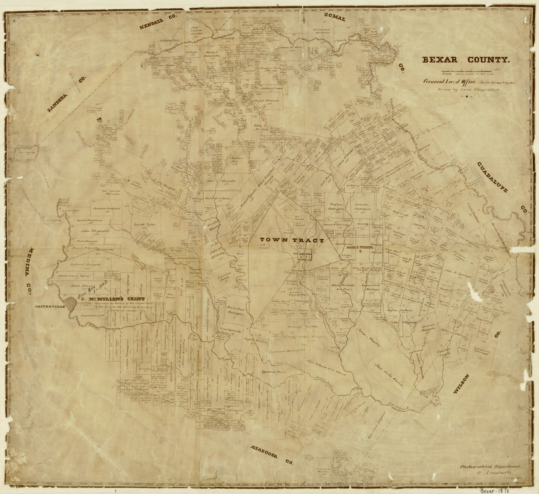
Bexar County
-
Map/Doc
3297
-
Collection
General Map Collection
-
Object Dates
7/1871 (Creation Date)
-
People and Organizations
Herman Lungkwitz (Draftsman)
Louis Klappenbach (Draftsman)
-
Counties
Bexar
-
Subjects
County
-
Height x Width
23.5 x 25.9 inches
59.7 x 65.8 cm
-
Features
Rossilla Creek
Old Road
Laredo Road
Parita Creek
Chupederas [sic] Creek
Caliveras Creek
Mission San Jose
San Antonio River
San Juan Ditch
Potranko [sic] Creek
Sous Creek
Castroville
Loma Alta
San Pedro Creek
Salado Creek
Cibolo Creek
Martinez Creek
San Antonio
Medio Creek
Castroville Road
Bandera Road
Bandera to Castroville Road
Loma de Culebra
Ponce Creek
Olmos Creek
Leon Creek
Helotes Creek
Medina River
Balkones [sic] Creek
Part of: General Map Collection
Jefferson Co.

Print $40.00
- Digital $50.00
Jefferson Co.
1978
Size 49.3 x 43.5 inches
Map/Doc 95546

Polk County Rolled Sketch TMS

Print $40.00
- Digital $50.00
Polk County Rolled Sketch TMS
1937
Size 35.7 x 56.5 inches
Map/Doc 9756

Approaches to Galveston Bay

Print $40.00
- Digital $50.00
Approaches to Galveston Bay
1972
Size 50.2 x 36.0 inches
Map/Doc 69881
Flight Mission No. BRE-2P, Frame 53, Nueces County

Print $20.00
- Digital $50.00
Flight Mission No. BRE-2P, Frame 53, Nueces County
1956
Size 18.4 x 22.2 inches
Map/Doc 86755

Flight Mission No. DQO-8K, Frame 71, Galveston County

Print $20.00
- Digital $50.00
Flight Mission No. DQO-8K, Frame 71, Galveston County
1952
Size 18.6 x 22.4 inches
Map/Doc 85175

Van Zandt County Working Sketch 9

Print $20.00
- Digital $50.00
Van Zandt County Working Sketch 9
1982
Size 12.6 x 11.7 inches
Map/Doc 72259
Starr County Rolled Sketch 15

Print $20.00
- Digital $50.00
Starr County Rolled Sketch 15
1913
Size 22.7 x 23.6 inches
Map/Doc 7800
Eastland County Working Sketch 17

Print $20.00
- Digital $50.00
Eastland County Working Sketch 17
1919
Size 18.3 x 16.2 inches
Map/Doc 68798
You may also like

Hartley County

Print $20.00
- Digital $50.00
Hartley County
1892
Size 25.0 x 20.0 inches
Map/Doc 90670
Culberson County Working Sketch 40a

Print $20.00
- Digital $50.00
Culberson County Working Sketch 40a
1981
Size 37.3 x 38.6 inches
Map/Doc 68494
Zapata County Rolled Sketch 19

Print $20.00
- Digital $50.00
Zapata County Rolled Sketch 19
1955
Size 29.0 x 20.9 inches
Map/Doc 8316
Map of Texas and Adjacent Regions in the Eighteenth Century

Print $20.00
- Digital $50.00
Map of Texas and Adjacent Regions in the Eighteenth Century
1915
Size 16.7 x 20.0 inches
Map/Doc 94007
Webb County Sketch File 19

Print $15.00
- Digital $50.00
Webb County Sketch File 19
1902
Size 9.2 x 17.0 inches
Map/Doc 39822
Palo Pinto County Rolled Sketch 13

Print $20.00
- Digital $50.00
Palo Pinto County Rolled Sketch 13
1986
Size 29.0 x 32.2 inches
Map/Doc 7193
[Pecos River Bed]
![2467, [Pecos River Bed], General Map Collection](https://historictexasmaps.com/wmedia_w700/maps/2467.tif.jpg)
Print $20.00
- Digital $50.00
[Pecos River Bed]
Size 16.6 x 39.8 inches
Map/Doc 2467
Live Oak County Working Sketch Graphic Index

Print $40.00
- Digital $50.00
Live Oak County Working Sketch Graphic Index
1947
Size 53.7 x 39.4 inches
Map/Doc 76623
Le Nouveau Mexique appelé aussi Nouvelle Grenade et Marata, avec partie de Californie

Print $20.00
- Digital $50.00
Le Nouveau Mexique appelé aussi Nouvelle Grenade et Marata, avec partie de Californie
1687
Size 21.5 x 25.5 inches
Map/Doc 96630
Map of Clay County, Texas

Print $20.00
- Digital $50.00
Map of Clay County, Texas
1880
Size 33.0 x 23.2 inches
Map/Doc 699
Haskell County Rolled Sketch 5

Print $20.00
- Digital $50.00
Haskell County Rolled Sketch 5
1858
Size 30.0 x 39.0 inches
Map/Doc 6165