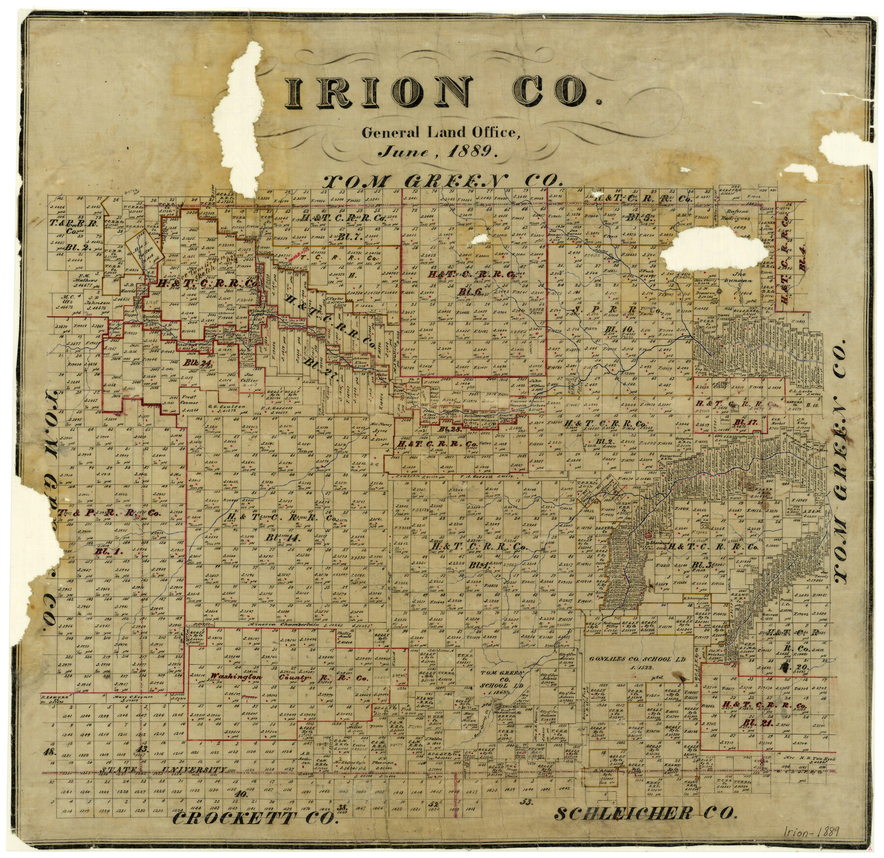
Irion County
-
Map/Doc
3698
-
Collection
General Map Collection
-
Object Dates
6/1889 (Creation Date)
-
People and Organizations
Texas General Land Office (Publisher)
-
Counties
Irion
-
Subjects
County
-
Height x Width
21.5 x 22.0 inches
54.6 x 55.9 cm
-
Features
Correll Creek
Majors Creek
Adams Creek
Annie's Creek
Sherwood
Good Spring Creek
Monument Mountain
Part of: General Map Collection
[Location Survey of the Southern Kansas Railway, Kiowa Extension from a point in Drake's Location, in Indian Territory 100 miles from south line of Kansas, continuing up Wolf Creek and South Canadian River to Cottonwood Creek in Hutchinson County]
![88843, [Location Survey of the Southern Kansas Railway, Kiowa Extension from a point in Drake's Location, in Indian Territory 100 miles from south line of Kansas, continuing up Wolf Creek and South Canadian River to Cottonwood Creek in Hutchinson County], General Map Collection](https://historictexasmaps.com/wmedia_w700/maps/88843.tif.jpg)
Print $20.00
- Digital $50.00
[Location Survey of the Southern Kansas Railway, Kiowa Extension from a point in Drake's Location, in Indian Territory 100 miles from south line of Kansas, continuing up Wolf Creek and South Canadian River to Cottonwood Creek in Hutchinson County]
1886
Size 39.0 x 40.0 inches
Map/Doc 88843
Brazoria County Sketch File 34

Print $4.00
- Digital $50.00
Brazoria County Sketch File 34
Size 14.3 x 8.9 inches
Map/Doc 15041
Anderson County Sketch File 18

Print $40.00
- Digital $50.00
Anderson County Sketch File 18
1880
Size 16.0 x 13.5 inches
Map/Doc 10801
Pecos County Sketch File 7

Print $20.00
- Digital $50.00
Pecos County Sketch File 7
Size 29.7 x 44.5 inches
Map/Doc 10568
Crockett County Rolled Sketch RC

Print $50.00
- Digital $50.00
Crockett County Rolled Sketch RC
1935
Size 43.2 x 31.1 inches
Map/Doc 8702
Limestone County Working Sketch 27

Print $20.00
- Digital $50.00
Limestone County Working Sketch 27
2008
Size 34.4 x 35.6 inches
Map/Doc 88767
Martin County Rolled Sketch 4

Print $20.00
- Digital $50.00
Martin County Rolled Sketch 4
1908
Size 40.9 x 24.8 inches
Map/Doc 6665
Wilbarger County Sketch File 20

Print $4.00
- Digital $50.00
Wilbarger County Sketch File 20
1885
Size 12.7 x 8.2 inches
Map/Doc 40217
Victoria County Working Sketch 7

Print $40.00
- Digital $50.00
Victoria County Working Sketch 7
1945
Size 55.3 x 18.0 inches
Map/Doc 72277
Val Verde County Rolled Sketch 74

Print $20.00
- Digital $50.00
Val Verde County Rolled Sketch 74
Size 18.9 x 19.5 inches
Map/Doc 8137
Mitchell County Sketch File 2

Print $22.00
- Digital $50.00
Mitchell County Sketch File 2
Size 9.1 x 14.0 inches
Map/Doc 31688
Treaty to Resolve Pending Boundary Differences and Maintain the Rio Grande and Colorado River as the International Boundary Between the United States of American and Mexico

Print $20.00
- Digital $50.00
Treaty to Resolve Pending Boundary Differences and Maintain the Rio Grande and Colorado River as the International Boundary Between the United States of American and Mexico
1970
Size 11.0 x 35.2 inches
Map/Doc 83105
You may also like
Brown County Sketch File 29

Print $6.00
- Digital $50.00
Brown County Sketch File 29
1924
Size 14.3 x 8.9 inches
Map/Doc 16628
Trinity River, Drop Sheet/Denton Creek

Print $20.00
- Digital $50.00
Trinity River, Drop Sheet/Denton Creek
1940
Size 36.9 x 34.0 inches
Map/Doc 65257
Lubbock County Boundary File 8

Print $46.00
- Digital $50.00
Lubbock County Boundary File 8
Size 7.3 x 8.7 inches
Map/Doc 56525
St. Louis Southwestern Railway of Texas

Print $20.00
- Digital $50.00
St. Louis Southwestern Railway of Texas
1906
Size 21.7 x 30.0 inches
Map/Doc 64452
Nueces River, Corpus Christi Sheet No. 6

Print $6.00
- Digital $50.00
Nueces River, Corpus Christi Sheet No. 6
1938
Size 31.3 x 31.0 inches
Map/Doc 65095
Estes Quadrangle

Print $20.00
- Digital $50.00
Estes Quadrangle
1971
Size 27.8 x 23.6 inches
Map/Doc 73442
Runnels County Sketch File 2

Print $6.00
Runnels County Sketch File 2
1854
Size 8.2 x 7.8 inches
Map/Doc 35431
Mud Creek in Nacogdoches District

Print $2.00
- Digital $50.00
Mud Creek in Nacogdoches District
1846
Size 10.7 x 7.8 inches
Map/Doc 345
Sabine County Sketch File 6b

Print $4.00
Sabine County Sketch File 6b
1879
Size 8.1 x 9.0 inches
Map/Doc 35617
Haskell County Sketch File 5

Print $4.00
- Digital $50.00
Haskell County Sketch File 5
1856
Size 10.1 x 8.1 inches
Map/Doc 26124
Wilbarger County Working Sketch 10

Print $20.00
- Digital $50.00
Wilbarger County Working Sketch 10
1951
Size 23.5 x 32.3 inches
Map/Doc 72548
Rains County Working Sketch 4

Print $20.00
- Digital $50.00
Rains County Working Sketch 4
1919
Size 27.3 x 25.9 inches
Map/Doc 71830