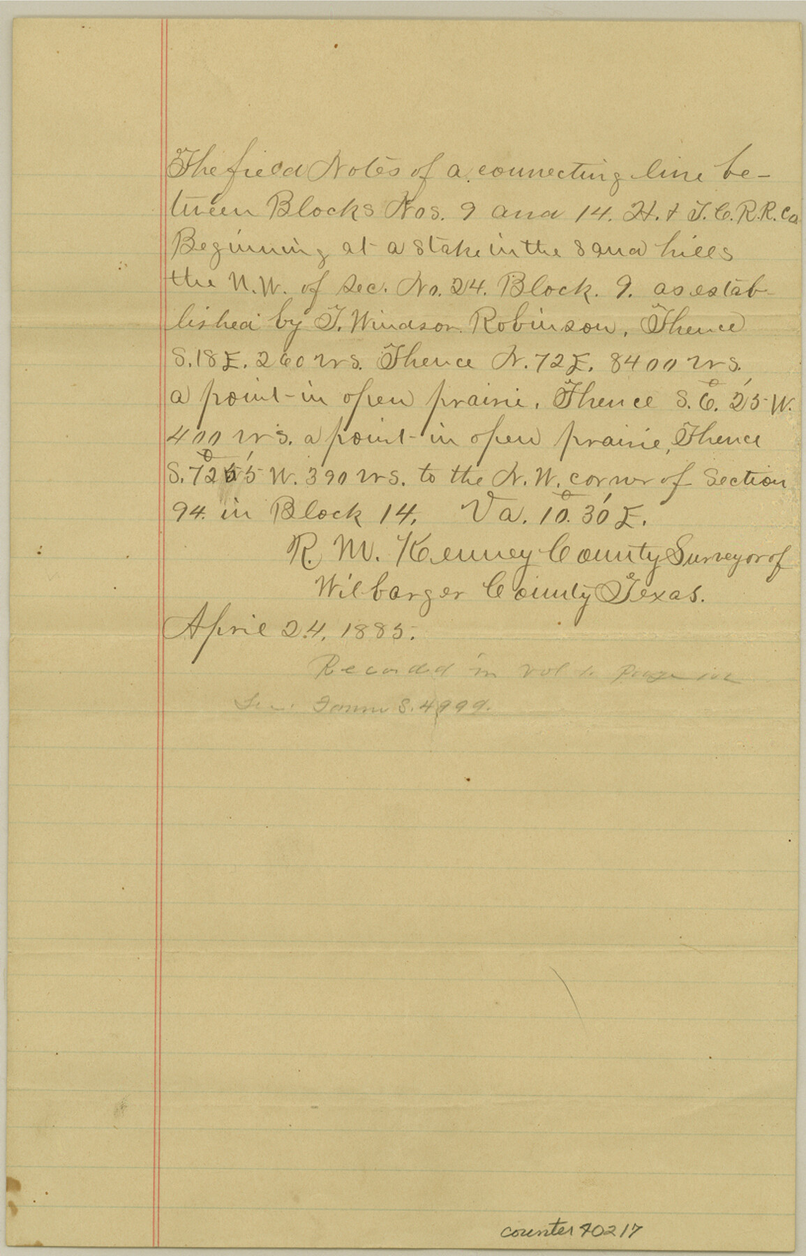
Wilbarger County Sketch File 20
[Field notes of a connecting line between H. & T. C. R.R. Co. Blocks 9 and 14]
-
Map/Doc
40217
-
Collection
General Map Collection
-
Object Dates
4/24/1885 (Creation Date)
5/16/1885 (File Date)
-
People and Organizations
R.M. Kenney (Surveyor/Engineer)
-
Counties
Wilbarger
-
Subjects
Surveying Sketch File
-
Height x Width
12.7 x 8.2 inches
32.3 x 20.8 cm
-
Medium
paper, manuscript
Part of: General Map Collection
[Right of Way & Track Map, The Texas & Pacific Ry. Co. Main Line]
![64663, [Right of Way & Track Map, The Texas & Pacific Ry. Co. Main Line], General Map Collection](https://historictexasmaps.com/wmedia_w700/maps/64663.tif.jpg)
Print $20.00
- Digital $50.00
[Right of Way & Track Map, The Texas & Pacific Ry. Co. Main Line]
Size 11.0 x 19.0 inches
Map/Doc 64663
America's Fun-Tier: Texas 1966 Official State Highway Map

Digital $50.00
America's Fun-Tier: Texas 1966 Official State Highway Map
Size 28.2 x 36.5 inches
Map/Doc 94324
Brewster County Rolled Sketch 152

Print $20.00
- Digital $50.00
Brewster County Rolled Sketch 152
1996
Size 28.0 x 36.5 inches
Map/Doc 5319
Orange County Working Sketch 53

Print $20.00
- Digital $50.00
Orange County Working Sketch 53
2007
Size 34.1 x 46.0 inches
Map/Doc 87371
[Corpus Christi Bay, Padre Island, Mustang Island, Laguna de la Madre, King and Kenedy's Pasture]
![73046, [Corpus Christi Bay, Padre Island, Mustang Island, Laguna de la Madre, King and Kenedy's Pasture], General Map Collection](https://historictexasmaps.com/wmedia_w700/maps/73046.tif.jpg)
Print $20.00
- Digital $50.00
[Corpus Christi Bay, Padre Island, Mustang Island, Laguna de la Madre, King and Kenedy's Pasture]
Size 26.4 x 18.2 inches
Map/Doc 73046
Presidio County Sketch File 45

Print $6.00
- Digital $50.00
Presidio County Sketch File 45
1914
Size 11.3 x 8.8 inches
Map/Doc 34532
Wharton County Rolled Sketch 7

Print $20.00
- Digital $50.00
Wharton County Rolled Sketch 7
Size 38.0 x 26.9 inches
Map/Doc 8231
Kinney County Working Sketch 43

Print $20.00
- Digital $50.00
Kinney County Working Sketch 43
1975
Size 42.9 x 33.5 inches
Map/Doc 70225
Crockett County Rolled Sketch 23

Print $20.00
- Digital $50.00
Crockett County Rolled Sketch 23
1924
Size 34.2 x 26.6 inches
Map/Doc 5583
Taylor County Rolled Sketch 28

Print $20.00
- Digital $50.00
Taylor County Rolled Sketch 28
Size 34.4 x 23.9 inches
Map/Doc 7921
Terrell County Working Sketch 53

Print $40.00
- Digital $50.00
Terrell County Working Sketch 53
1958
Size 61.9 x 39.7 inches
Map/Doc 62146
Map of Matagorda Bay and County, with the adjacent country

Print $20.00
- Digital $50.00
Map of Matagorda Bay and County, with the adjacent country
1846
Size 18.3 x 26.0 inches
Map/Doc 72765
You may also like
The Republic County of Bastrop. December 29, 1845

Print $20.00
The Republic County of Bastrop. December 29, 1845
2020
Size 14.8 x 21.7 inches
Map/Doc 96092
Chambers County Rolled Sketch 32

Print $20.00
- Digital $50.00
Chambers County Rolled Sketch 32
1951
Size 26.7 x 37.8 inches
Map/Doc 5432
Map of Bexar County

Print $40.00
- Digital $50.00
Map of Bexar County
1845
Size 90.6 x 81.0 inches
Map/Doc 82242
Mills County Rolled Sketch 6

Print $20.00
- Digital $50.00
Mills County Rolled Sketch 6
2007
Size 24.4 x 36.6 inches
Map/Doc 88738
Flight Mission No. CUG-2P, Frame 23, Kleberg County

Print $20.00
- Digital $50.00
Flight Mission No. CUG-2P, Frame 23, Kleberg County
1956
Size 18.6 x 22.3 inches
Map/Doc 86187
Chambers County Rolled Sketch 18

Print $20.00
- Digital $50.00
Chambers County Rolled Sketch 18
1937
Size 42.9 x 29.0 inches
Map/Doc 5426
La Salle County Sketch File 27

Print $22.00
- Digital $50.00
La Salle County Sketch File 27
Size 8.8 x 14.1 inches
Map/Doc 29553
Presidio County Sketch File 63

Print $4.00
- Digital $50.00
Presidio County Sketch File 63
1939
Size 20.7 x 22.3 inches
Map/Doc 11718
Denton County Working Sketch 16

Print $20.00
- Digital $50.00
Denton County Working Sketch 16
1973
Size 31.5 x 39.1 inches
Map/Doc 68621
Hutchinson County Working Sketch 45

Print $20.00
- Digital $50.00
Hutchinson County Working Sketch 45
1979
Size 20.3 x 17.5 inches
Map/Doc 66405
Harris County Sketch File 33a

Print $20.00
- Digital $50.00
Harris County Sketch File 33a
Size 34.1 x 30.0 inches
Map/Doc 10478
Liberty County Rolled Sketch M

Print $40.00
- Digital $50.00
Liberty County Rolled Sketch M
1953
Size 23.6 x 56.6 inches
Map/Doc 10651