Briscoe County Boundary File 6
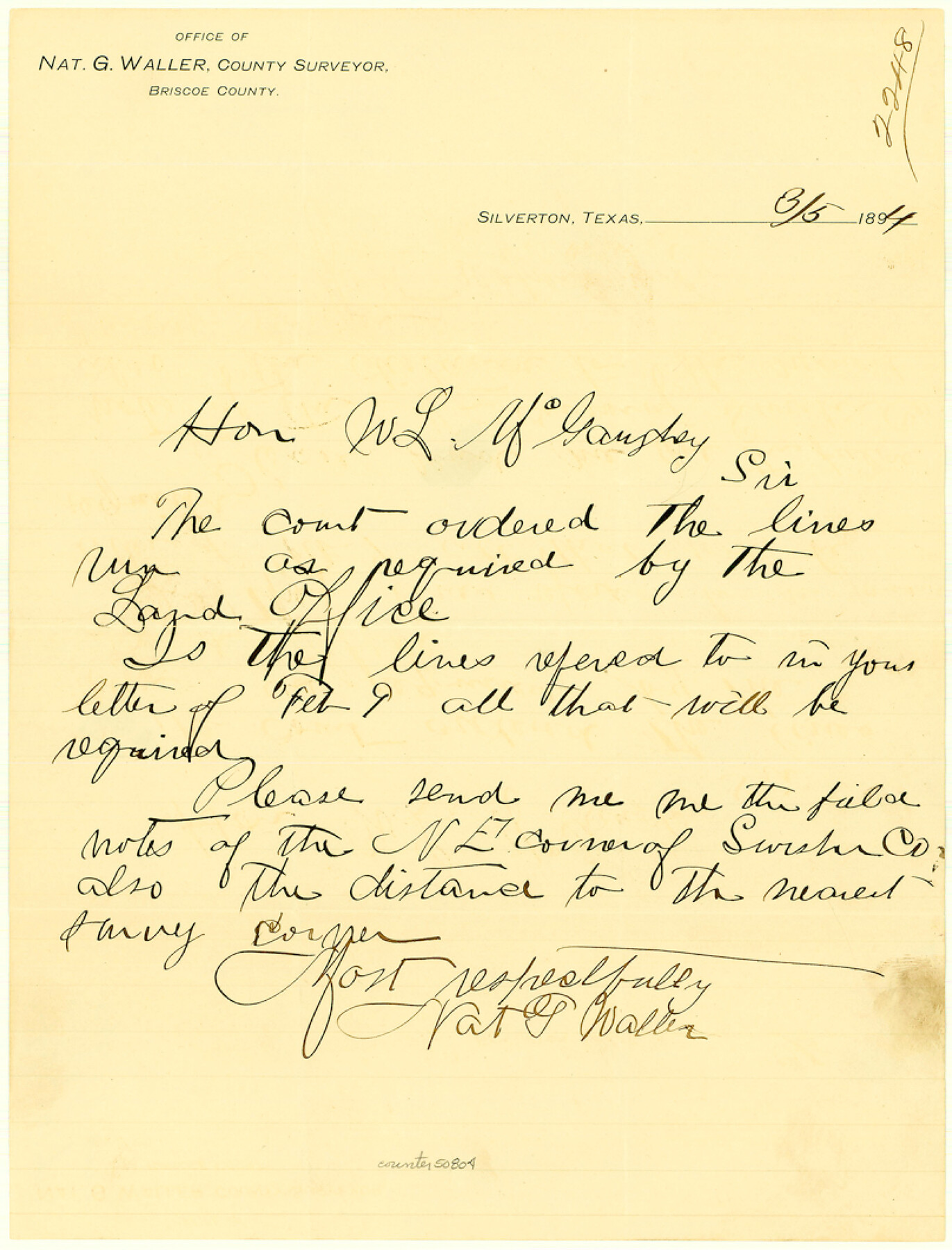
[Letter requesting the filed notes of the NE corner of Swisher Co. and the NW corner of Briscoe Co.]
-
Map/Doc
50804
-
Collection
General Map Collection
-
Counties
Briscoe
-
Subjects
County Boundaries
-
Height x Width
10.6 x 8.1 inches
26.9 x 20.6 cm
Part of: General Map Collection
Hall County Sketch File C2

Print $6.00
- Digital $50.00
Hall County Sketch File C2
1905
Size 14.4 x 9.0 inches
Map/Doc 24789
[Surveys in Austin's Colony on both sides of the Navidad River]
![217, [Surveys in Austin's Colony on both sides of the Navidad River], General Map Collection](https://historictexasmaps.com/wmedia_w700/maps/217.tif.jpg)
Print $20.00
- Digital $50.00
[Surveys in Austin's Colony on both sides of the Navidad River]
1831
Size 18.8 x 12.7 inches
Map/Doc 217
Flight Mission No. CGI-3N, Frame 127, Cameron County

Print $20.00
- Digital $50.00
Flight Mission No. CGI-3N, Frame 127, Cameron County
1954
Size 18.8 x 22.4 inches
Map/Doc 84600

Presidio County Rolled Sketch 100

Print $20.00
- Digital $50.00
Presidio County Rolled Sketch 100
1954
Size 30.4 x 30.2 inches
Map/Doc 7382
Coke County Rolled Sketch 7

Print $20.00
- Digital $50.00
Coke County Rolled Sketch 7
Size 19.0 x 24.1 inches
Map/Doc 5506
Tarrant County Sketch File 15

Print $4.00
- Digital $50.00
Tarrant County Sketch File 15
1859
Size 13.2 x 8.1 inches
Map/Doc 37708
United States - Gulf Coast Texas - Southern part of Laguna Madre

Print $20.00
- Digital $50.00
United States - Gulf Coast Texas - Southern part of Laguna Madre
1941
Size 26.5 x 18.3 inches
Map/Doc 72955
Aransas County Working Sketch 14

Print $20.00
- Digital $50.00
Aransas County Working Sketch 14
1951
Size 22.5 x 22.3 inches
Map/Doc 67181
Maps of Gulf Intracoastal Waterway, Texas - Sabine River to the Rio Grande and connecting waterways including ship channels

Print $20.00
- Digital $50.00
Maps of Gulf Intracoastal Waterway, Texas - Sabine River to the Rio Grande and connecting waterways including ship channels
1966
Size 14.6 x 20.5 inches
Map/Doc 62000
Presidio County Sketch File 105

Print $20.00
- Digital $50.00
Presidio County Sketch File 105
Size 15.6 x 42.6 inches
Map/Doc 11726
T. & G. Ry. Main Line, Texas, Right of Way Map, Center to Gary

Print $40.00
- Digital $50.00
T. & G. Ry. Main Line, Texas, Right of Way Map, Center to Gary
1917
Size 32.4 x 122.8 inches
Map/Doc 64570
You may also like
Victoria County Rolled Sketch 4B

Print $40.00
- Digital $50.00
Victoria County Rolled Sketch 4B
1963
Size 65.3 x 43.3 inches
Map/Doc 10096
Randall County

Print $20.00
- Digital $50.00
Randall County
1879
Size 21.4 x 19.2 inches
Map/Doc 3974
Hutchinson County Rolled Sketch 18

Print $20.00
- Digital $50.00
Hutchinson County Rolled Sketch 18
Size 30.4 x 32.6 inches
Map/Doc 9244
Fisher County Sketch File 7

Print $4.00
- Digital $50.00
Fisher County Sketch File 7
1893
Size 14.6 x 9.1 inches
Map/Doc 22565
Lampasas County Sketch File 9

Print $4.00
- Digital $50.00
Lampasas County Sketch File 9
1873
Size 9.4 x 7.3 inches
Map/Doc 29408
Presidio County Working Sketch 114

Print $40.00
- Digital $50.00
Presidio County Working Sketch 114
1981
Size 63.9 x 37.9 inches
Map/Doc 71791
Sketch of Ed Trigg School File

Print $20.00
- Digital $50.00
Sketch of Ed Trigg School File
1929
Size 40.0 x 21.6 inches
Map/Doc 91254
Trinity River, Trinidad Sheet

Print $20.00
- Digital $50.00
Trinity River, Trinidad Sheet
1928
Size 39.0 x 46.3 inches
Map/Doc 65183
Galveston County Rolled Sketch 31

Print $20.00
- Digital $50.00
Galveston County Rolled Sketch 31
1979
Size 28.4 x 39.8 inches
Map/Doc 5965
Rusk County Sketch File 40

Print $20.00
Rusk County Sketch File 40
1951
Size 23.2 x 26.6 inches
Map/Doc 12276
Hutchinson Co.

Print $20.00
- Digital $50.00
Hutchinson Co.
1891
Size 27.5 x 21.3 inches
Map/Doc 4986
Val Verde County Sketch File C

Print $62.00
- Digital $50.00
Val Verde County Sketch File C
1898
Size 15.5 x 19.8 inches
Map/Doc 12545