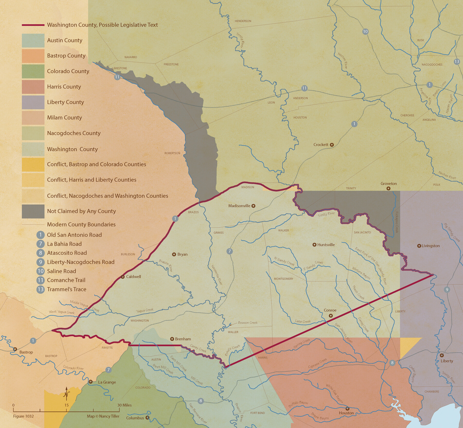
Text (Possibly Legislative) Describing the Boundaries of Washington County, Undated
Figure No. 1032 from 'A Boundary Atlas of Texas, 1821-1845' by Jim Tiller
-
Map/Doc
96407
-
Collection
Nancy and Jim Tiller Digital Collection
-
Object Dates
2020/1/1 (Creation Date)
-
People and Organizations
Jim Tiller (Author)
Nancy Tiller (Cartographer)
Gang Gong (GIS Professional)
-
Subjects
Atlas Republic of Texas Texas Boundaries
-
Height x Width
20.0 x 21.7 inches
50.8 x 55.1 cm
-
Medium
digital image
-
Comments
To purchase a digital PDF copy of "A Boundary Atlas of Texas, 1821-1845" see 96437.
Part of: Nancy and Jim Tiller Digital Collection
The Republic County of Colorado. 1840

Print $20.00
The Republic County of Colorado. 1840
2020
Size 18.4 x 21.7 inches
Map/Doc 96122
The Republic County of Liberty. Spring 1842

Print $20.00
The Republic County of Liberty. Spring 1842
2020
Size 19.9 x 21.7 inches
Map/Doc 96212
The Republic County of Nacogdoches. Proposed, Late Fall 1837

Print $20.00
The Republic County of Nacogdoches. Proposed, Late Fall 1837
2020
Size 17.5 x 21.7 inches
Map/Doc 96242
The Republic County of Goliad. Boundaries Defined, December 2, 1841

Print $20.00
The Republic County of Goliad. Boundaries Defined, December 2, 1841
2020
Size 17.5 x 21.7 inches
Map/Doc 96151
The Mexican Municipalities. On the Eve of Texas Independence, 1836

Print $20.00
The Mexican Municipalities. On the Eve of Texas Independence, 1836
2020
Size 17.2 x 21.6 inches
Map/Doc 96013
The Republic County of Bexar. North View. Proposed, Fall 1837-December 31, 1838

Print $20.00
The Republic County of Bexar. North View. Proposed, Fall 1837-December 31, 1838
2020
Size 14.0 x 21.1 inches
Map/Doc 96094
The Republic County of Harris. December 29, 1845

Print $20.00
The Republic County of Harris. December 29, 1845
2020
Size 17.7 x 21.7 inches
Map/Doc 96168
Vehlein and Company Empresario Colony. December 21, 1826

Print $20.00
Vehlein and Company Empresario Colony. December 21, 1826
2020
Size 20.8 x 21.7 inches
Map/Doc 96007
The Judicial District/County of Neches. Created, January 29, 1842

Print $20.00
The Judicial District/County of Neches. Created, January 29, 1842
2020
Size 15.5 x 21.7 inches
Map/Doc 96338
The Republic County of Montgomery. January 25, 1840

Print $20.00
The Republic County of Montgomery. January 25, 1840
2020
Size 19.9 x 21.7 inches
Map/Doc 96237
The Republic County of Matagorda. Proposed, Late Fall 1837-January 1, 1838

Print $20.00
The Republic County of Matagorda. Proposed, Late Fall 1837-January 1, 1838
2020
Size 21.0 x 21.7 inches
Map/Doc 96215
The Republic County of Victoria. Boundaries Refined, January 25, 1841

Print $20.00
The Republic County of Victoria. Boundaries Refined, January 25, 1841
2020
Size 19.3 x 21.8 inches
Map/Doc 96297
You may also like
Menard County Boundary File 1a

Print $8.00
- Digital $50.00
Menard County Boundary File 1a
Size 12.7 x 8.2 inches
Map/Doc 57042
Crockett County Rolled Sketch P

Print $20.00
- Digital $50.00
Crockett County Rolled Sketch P
1927
Size 24.3 x 47.3 inches
Map/Doc 8696
McMullen County Sketch File 39

Print $4.00
- Digital $50.00
McMullen County Sketch File 39
1938
Size 13.3 x 8.7 inches
Map/Doc 31413
Flight Mission No. DQN-6K, Frame 17, Calhoun County

Print $20.00
- Digital $50.00
Flight Mission No. DQN-6K, Frame 17, Calhoun County
1953
Size 18.5 x 22.1 inches
Map/Doc 84439
Galveston County NRC Article 33.136 Sketch 94

Print $72.00
Galveston County NRC Article 33.136 Sketch 94
2024
Map/Doc 97293
Wharton County Working Sketch 14

Print $20.00
- Digital $50.00
Wharton County Working Sketch 14
1961
Size 26.5 x 24.9 inches
Map/Doc 72478
Map of Jefferson County

Print $20.00
- Digital $50.00
Map of Jefferson County
1862
Size 22.5 x 21.9 inches
Map/Doc 3727
Sutton County Rolled Sketch 65

Print $20.00
- Digital $50.00
Sutton County Rolled Sketch 65
Size 40.8 x 30.5 inches
Map/Doc 7900
Bowie County Sketch File 8c

Print $32.00
- Digital $50.00
Bowie County Sketch File 8c
1928
Size 8.1 x 5.3 inches
Map/Doc 14878
Brewster County Rolled Sketch 59CC

Print $20.00
- Digital $50.00
Brewster County Rolled Sketch 59CC
1939
Size 18.3 x 24.9 inches
Map/Doc 5230
Pas Kaart van de Golff van Mexico

Print $20.00
- Digital $50.00
Pas Kaart van de Golff van Mexico
1695
Size 21.4 x 25.4 inches
Map/Doc 94081
Bird's Eye View of Corpus Christi

Print $20.00
Bird's Eye View of Corpus Christi
1887
Size 21.4 x 28.0 inches
Map/Doc 94113