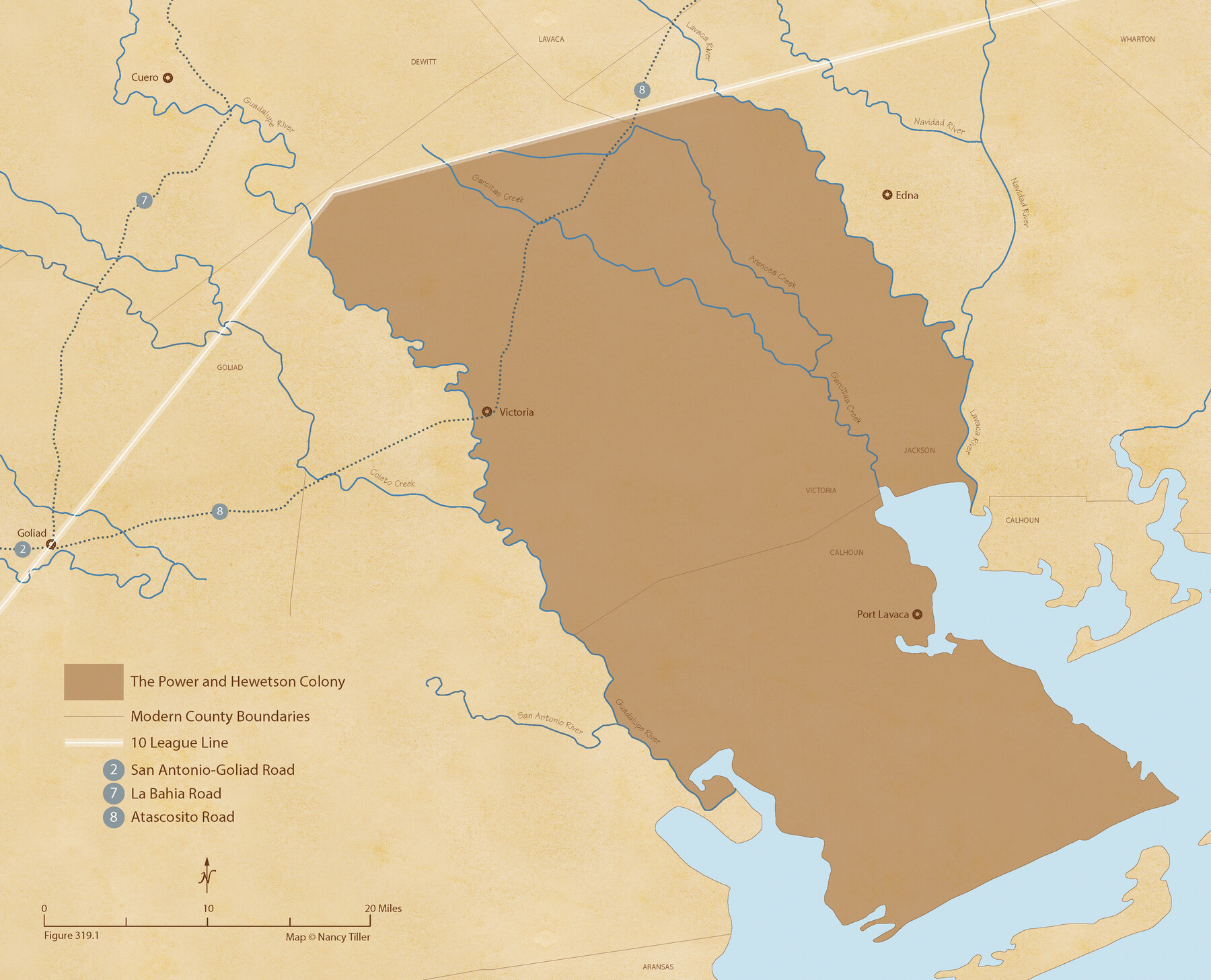
Power and Hewetson Empresario Colony. June 11, 1828
Figure No. 319.1 from 'A Boundary Atlas of Texas, 1821-1845' by Jim Tiller
-
Map/Doc
96003
-
Collection
Nancy and Jim Tiller Digital Collection
-
Object Dates
2020/1/1 (Creation Date)
-
People and Organizations
Jim Tiller (Author)
Nancy Tiller (Cartographer)
Gang Gong (GIS Professional)
-
Subjects
Atlas Colony Mexican Texas Texas Boundaries
-
Height x Width
17.5 x 21.7 inches
44.5 x 55.1 cm
-
Medium
digital image
-
Comments
To purchase a digital PDF copy of "A Boundary Atlas of Texas, 1821-1845" see 96437.
Part of: Nancy and Jim Tiller Digital Collection
The Republic County of Lamar. December 26, 1842

Print $20.00
The Republic County of Lamar. December 26, 1842
2020
Size 16.4 x 21.7 inches
Map/Doc 96205
The Chief Justice County of Matagorda. March 30, 1837

Print $20.00
The Chief Justice County of Matagorda. March 30, 1837
2020
Size 19.7 x 21.7 inches
Map/Doc 96057
The Chief Justice County of Harrisburg. Lands in Conflict with Brazoria, Liberty Counties

Print $20.00
The Chief Justice County of Harrisburg. Lands in Conflict with Brazoria, Liberty Counties
2020
Size 17.5 x 21.7 inches
Map/Doc 96050
The Republic County of Brazoria. Proposed, Late Fall 1837

Print $20.00
The Republic County of Brazoria. Proposed, Late Fall 1837
2020
Size 13.0 x 21.7 inches
Map/Doc 96109
From Citizens of Southwestern Nacogdoches County for the Creation of a New Judicial County (Unnamed), Undated

Print $20.00
From Citizens of Southwestern Nacogdoches County for the Creation of a New Judicial County (Unnamed), Undated
2020
Size 19.9 x 21.7 inches
Map/Doc 96412
The Chief Justice County of Sabine. Lands in Conflict with Jasper and San Augustine Counties

Print $20.00
The Chief Justice County of Sabine. Lands in Conflict with Jasper and San Augustine Counties
2020
Size 20.0 x 21.7 inches
Map/Doc 96069
The Republic County of Bexar. November 28, 1839

Print $20.00
The Republic County of Bexar. November 28, 1839
2020
Size 14.8 x 21.1 inches
Map/Doc 96097
The Republic County of Fayette. January 29, 1842

Print $20.00
The Republic County of Fayette. January 29, 1842
2020
Size 14.7 x 21.7 inches
Map/Doc 96134
The Republic County of Milam. December 29, 1845

Print $20.00
The Republic County of Milam. December 29, 1845
2020
Size 17.4 x 21.6 inches
Map/Doc 96233
The Republic County of Liberty. December 29, 1845

Print $20.00
The Republic County of Liberty. December 29, 1845
2020
Size 19.9 x 21.7 inches
Map/Doc 96213
The Republic County of Travis. January 29, 1842

Print $20.00
The Republic County of Travis. January 29, 1842
2020
Size 20.8 x 21.6 inches
Map/Doc 96291
The Republic County of Fannin. December 29, 1845

Print $20.00
The Republic County of Fannin. December 29, 1845
2020
Size 12.9 x 21.7 inches
Map/Doc 96130
You may also like
[Garza, Blanco, Uvalde and Crosby County School Land]
![90250, [Garza, Blanco, Uvalde and Crosby County School Land], Twichell Survey Records](https://historictexasmaps.com/wmedia_w700/maps/90250-1.tif.jpg)
Print $3.00
- Digital $50.00
[Garza, Blanco, Uvalde and Crosby County School Land]
1913
Size 14.6 x 11.8 inches
Map/Doc 90250
Flight Mission No. BQR-9K, Frame 12, Brazoria County

Print $20.00
- Digital $50.00
Flight Mission No. BQR-9K, Frame 12, Brazoria County
1952
Size 18.8 x 22.3 inches
Map/Doc 84041
Lavaca County Working Sketch 7

Print $20.00
- Digital $50.00
Lavaca County Working Sketch 7
1945
Size 23.6 x 26.2 inches
Map/Doc 70360
Culberson County Sketch File 4a

Print $10.00
- Digital $50.00
Culberson County Sketch File 4a
Size 9.2 x 7.9 inches
Map/Doc 20131
Van Zandt County Sketch File 33

Print $8.00
- Digital $50.00
Van Zandt County Sketch File 33
1860
Size 12.4 x 7.8 inches
Map/Doc 39469
Starr County Sketch File 17

Print $24.00
- Digital $50.00
Starr County Sketch File 17
1880
Size 12.8 x 8.2 inches
Map/Doc 36874
Colorado County Working Sketch 2

Print $20.00
- Digital $50.00
Colorado County Working Sketch 2
1904
Size 28.8 x 30.1 inches
Map/Doc 68102
Calhoun County NRC Article 33.136 Sketch 9

Print $106.00
- Digital $50.00
Calhoun County NRC Article 33.136 Sketch 9
2021
Map/Doc 96913
Flight Mission No. DQN-1K, Frame 140, Calhoun County

Print $20.00
- Digital $50.00
Flight Mission No. DQN-1K, Frame 140, Calhoun County
1953
Size 18.5 x 22.2 inches
Map/Doc 84203
Val Verde County Sketch File Z17

Print $24.00
- Digital $50.00
Val Verde County Sketch File Z17
1907
Size 23.7 x 17.5 inches
Map/Doc 12558
Johnson County Rolled Sketch 4

Print $20.00
- Digital $50.00
Johnson County Rolled Sketch 4
Size 24.8 x 36.0 inches
Map/Doc 94047
Goliad County Sketch File 5

Print $6.00
- Digital $50.00
Goliad County Sketch File 5
Size 15.9 x 10.2 inches
Map/Doc 24218