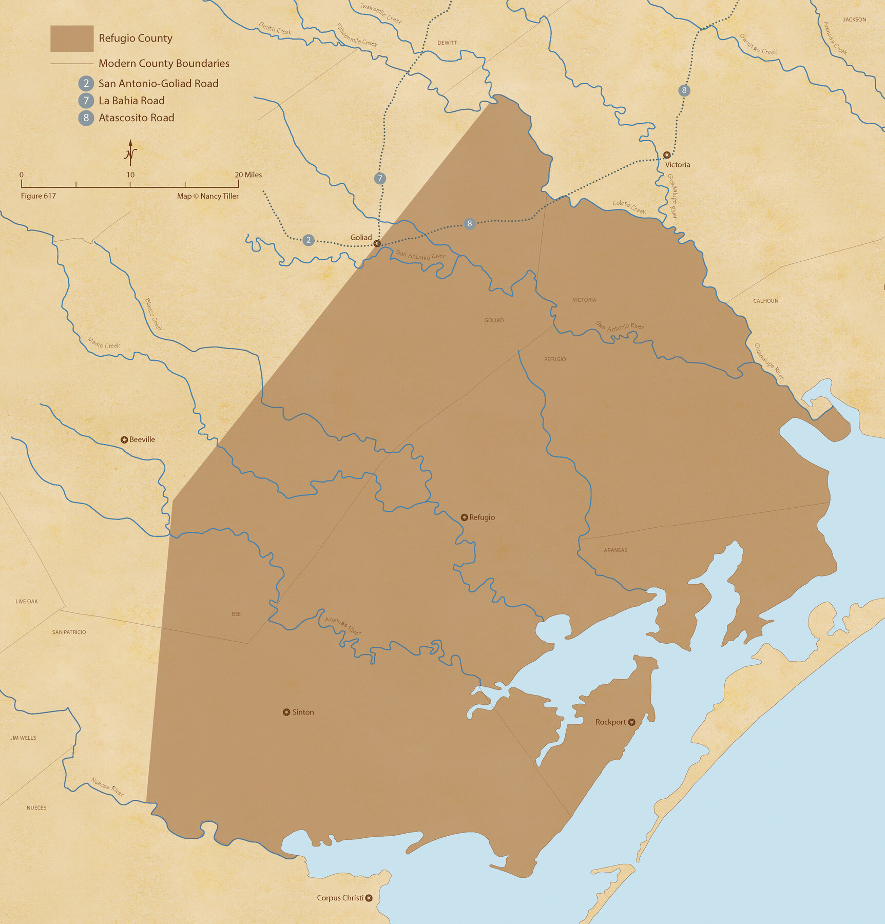
The Chief Justice County of Refugio. Proposed, No Date
Figure No. 617 from 'A Boundary Atlas of Texas, 1821-1845' by Jim Tiller
-
Map/Doc
96067
-
Collection
Nancy and Jim Tiller Digital Collection
-
Object Dates
2020/1/1 (Creation Date)
-
People and Organizations
Jim Tiller (Author)
Nancy Tiller (Cartographer)
Gang Gong (GIS Professional)
-
Subjects
Atlas Republic of Texas Texas Boundaries
-
Height x Width
11.3 x 10.8 inches
28.7 x 27.4 cm
-
Medium
digital image
-
Comments
To purchase a digital PDF copy of "A Boundary Atlas of Texas, 1821-1845" see 96437.
Part of: Nancy and Jim Tiller Digital Collection
The Republic County of Matagorda. September 17, 1838
![96217, The Republic County of Matagorda. September 17, 1838, Nancy and Jim Tiller Digital Collection](https://historictexasmaps.com/wmedia_w700/maps/96217.tif.jpg)
Print $20.00
- Digital $50.00
The Republic County of Matagorda. September 17, 1838
2020
Size 10.5 x 10.8 inches
Map/Doc 96217
The Republic County of Austin. February 1, 1844
![96087, The Republic County of Austin. February 1, 1844, Nancy and Jim Tiller Digital Collection](https://historictexasmaps.com/wmedia_w700/maps/96087.tif.jpg)
Print $20.00
- Digital $50.00
The Republic County of Austin. February 1, 1844
2020
Size 7.4 x 10.8 inches
Map/Doc 96087
The Mexican Company Empresario Colony. May 1, 1832
![95999, The Mexican Company Empresario Colony. May 1, 1832, Nancy and Jim Tiller Digital Collection](https://historictexasmaps.com/wmedia_w700/maps/95999.tif.jpg)
Print $20.00
- Digital $50.00
The Mexican Company Empresario Colony. May 1, 1832
2020
Size 7.5 x 10.9 inches
Map/Doc 95999
Text (Possibly Legislative) Describing the Boundaries of Washington County, Undated
![96407, Text (Possibly Legislative) Describing the Boundaries of Washington County, Undated, Nancy and Jim Tiller Digital Collection](https://historictexasmaps.com/wmedia_w700/maps/96407.tif.jpg)
Print $20.00
- Digital $50.00
Text (Possibly Legislative) Describing the Boundaries of Washington County, Undated
2020
Size 10.0 x 10.8 inches
Map/Doc 96407
The Judicial District/County of Burleson. Created, January 15, 1842
![96320, The Judicial District/County of Burleson. Created, January 15, 1842, Nancy and Jim Tiller Digital Collection](https://historictexasmaps.com/wmedia_w700/maps/96320.tif.jpg)
Print $20.00
- Digital $50.00
The Judicial District/County of Burleson. Created, January 15, 1842
2020
Size 7.0 x 10.8 inches
Map/Doc 96320
The Republic County of Jasper. Boundaries Defined, December 14, 1837
![96193, The Republic County of Jasper. Boundaries Defined, December 14, 1837, Nancy and Jim Tiller Digital Collection](https://historictexasmaps.com/wmedia_w700/maps/96193.tif.jpg)
Print $20.00
- Digital $50.00
The Republic County of Jasper. Boundaries Defined, December 14, 1837
2020
Size 9.8 x 10.8 inches
Map/Doc 96193
The Republic County of Milam. December 29, 1845
![96233, The Republic County of Milam. December 29, 1845, Nancy and Jim Tiller Digital Collection](https://historictexasmaps.com/wmedia_w700/maps/96233.tif.jpg)
Print $20.00
- Digital $50.00
The Republic County of Milam. December 29, 1845
2020
Size 8.7 x 10.8 inches
Map/Doc 96233
The Republic County of Bastrop. May 24, 1838
![96090, The Republic County of Bastrop. May 24, 1838, Nancy and Jim Tiller Digital Collection](https://historictexasmaps.com/wmedia_w700/maps/96090.tif.jpg)
Print $20.00
- Digital $50.00
The Republic County of Bastrop. May 24, 1838
2020
Size 8.9 x 10.8 inches
Map/Doc 96090
The Republic County of Jefferson. December 29, 1845
![96201, The Republic County of Jefferson. December 29, 1845, Nancy and Jim Tiller Digital Collection](https://historictexasmaps.com/wmedia_w700/maps/96201.tif.jpg)
Print $20.00
- Digital $50.00
The Republic County of Jefferson. December 29, 1845
2020
Size 11.3 x 10.8 inches
Map/Doc 96201
The Republic County of Galveston. January 20, 1841
![96145, The Republic County of Galveston. January 20, 1841, Nancy and Jim Tiller Digital Collection](https://historictexasmaps.com/wmedia_w700/maps/96145.tif.jpg)
Print $20.00
- Digital $50.00
The Republic County of Galveston. January 20, 1841
2020
Size 7.4 x 11.0 inches
Map/Doc 96145
The Republic County of Colorado. December 29, 1845
![96127, The Republic County of Colorado. December 29, 1845, Nancy and Jim Tiller Digital Collection](https://historictexasmaps.com/wmedia_w700/maps/96127.tif.jpg)
Print $20.00
- Digital $50.00
The Republic County of Colorado. December 29, 1845
2020
Size 9.2 x 10.8 inches
Map/Doc 96127
You may also like
Presidio County Sketch File 119
![34927, Presidio County Sketch File 119, General Map Collection](https://historictexasmaps.com/wmedia_w700/pdf_converted_jpg/qi_pdf_thumbnail_13785.jpg)
Print $14.00
- Digital $50.00
Presidio County Sketch File 119
1996
Size 14.3 x 9.0 inches
Map/Doc 34927
[E. L. & R. R. RR. Co. Blocks 10 and 32, T. & P. R.R. Co. Blocks 30 and 31, Tsp 6N]
![90216, [E. L. & R. R. RR. Co. Blocks 10 and 32, T. & P. R.R. Co. Blocks 30 and 31, Tsp 6N], Twichell Survey Records](https://historictexasmaps.com/wmedia_w700/maps/90216-1.tif.jpg)
Print $20.00
- Digital $50.00
[E. L. & R. R. RR. Co. Blocks 10 and 32, T. & P. R.R. Co. Blocks 30 and 31, Tsp 6N]
Size 21.7 x 17.7 inches
Map/Doc 90216
Map of Voss, Texas, Coleman County
![81519, Map of Voss, Texas, Coleman County, General Map Collection](https://historictexasmaps.com/wmedia_w700/maps/81519.tif.jpg)
Print $20.00
- Digital $50.00
Map of Voss, Texas, Coleman County
Size 15.8 x 16.0 inches
Map/Doc 81519
Flight Mission No. CUG-3P, Frame 190, Kleberg County
![86294, Flight Mission No. CUG-3P, Frame 190, Kleberg County, General Map Collection](https://historictexasmaps.com/wmedia_w700/pdf_converted_jpg/qi_pdf_thumbnail_33438.jpg)
Print $20.00
- Digital $50.00
Flight Mission No. CUG-3P, Frame 190, Kleberg County
1956
Size 18.6 x 22.4 inches
Map/Doc 86294
In the Supreme Court of the United States, The State of Oklahoma, Complainant vs. The State of Texas, Defendant, The United States of America, Intervener, Red River Valley, Texas and Oklahoma Between the 98th and 100th Meridians in Five Sheets, 1921
![75276, In the Supreme Court of the United States, The State of Oklahoma, Complainant vs. The State of Texas, Defendant, The United States of America, Intervener, Red River Valley, Texas and Oklahoma Between the 98th and 100th Meridians in Five Sheets, 1921, General Map Collection](https://historictexasmaps.com/wmedia_w700/maps/75276.tif.jpg)
Print $40.00
- Digital $50.00
In the Supreme Court of the United States, The State of Oklahoma, Complainant vs. The State of Texas, Defendant, The United States of America, Intervener, Red River Valley, Texas and Oklahoma Between the 98th and 100th Meridians in Five Sheets, 1921
1921
Size 38.6 x 60.0 inches
Map/Doc 75276
Part of Lea County
![92438, Part of Lea County, Twichell Survey Records](https://historictexasmaps.com/wmedia_w700/maps/92438.tif.jpg)
Print $20.00
- Digital $50.00
Part of Lea County
Size 42.2 x 35.5 inches
Map/Doc 92438
Bee County Sketch File 33
![14349, Bee County Sketch File 33, General Map Collection](https://historictexasmaps.com/wmedia_w700/pdf_converted_jpg/qi_pdf_thumbnail_9345.jpg)
Print $56.00
- Digital $50.00
Bee County Sketch File 33
Size 11.3 x 8.9 inches
Map/Doc 14349
Harris County Rolled Sketch T1
![6144, Harris County Rolled Sketch T1, General Map Collection](https://historictexasmaps.com/wmedia_w700/maps/6144.tif.jpg)
Print $20.00
- Digital $50.00
Harris County Rolled Sketch T1
Size 29.8 x 24.3 inches
Map/Doc 6144
Duval County Sketch File 68
![11407, Duval County Sketch File 68, General Map Collection](https://historictexasmaps.com/wmedia_w700/pdf_converted_jpg/qi_pdf_thumbnail_7873.jpg)
Print $20.00
- Digital $50.00
Duval County Sketch File 68
Size 23.9 x 19.6 inches
Map/Doc 11407
[Surveys in McMullen and McGloin's Colony along the San Antonio River]
![30, [Surveys in McMullen and McGloin's Colony along the San Antonio River], General Map Collection](https://historictexasmaps.com/wmedia_w700/maps/30-1.tif.jpg)
Print $20.00
- Digital $50.00
[Surveys in McMullen and McGloin's Colony along the San Antonio River]
1828
Size 19.3 x 24.5 inches
Map/Doc 30
[Sketch showing H. T. & B. section 126 and B. H. Epperson]
![90932, [Sketch showing H. T. & B. section 126 and B. H. Epperson], Twichell Survey Records](https://historictexasmaps.com/wmedia_w700/maps/90932-1.tif.jpg)
Print $20.00
- Digital $50.00
[Sketch showing H. T. & B. section 126 and B. H. Epperson]
Size 23.9 x 32.5 inches
Map/Doc 90932
Collingsworth County Working Sketch 5
![68093, Collingsworth County Working Sketch 5, General Map Collection](https://historictexasmaps.com/wmedia_w700/maps/68093.tif.jpg)
Print $20.00
- Digital $50.00
Collingsworth County Working Sketch 5
Size 22.5 x 38.2 inches
Map/Doc 68093