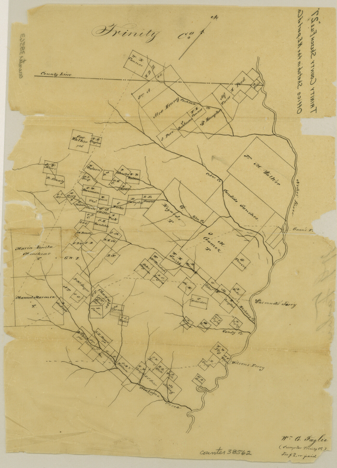
Trinity County Sketch File 27
[Office sketch of surveys west of the Neches River from the county line with Houston County to Alabama Creek in the south]
-
Map/Doc
38562
-
Collection
General Map Collection
-
Counties
Trinity Houston
-
Subjects
Surveying Sketch File
-
Height x Width
12.0 x 8.6 inches
30.5 x 21.8 cm
-
Medium
paper, manuscript
-
Features
Cochina Creek
Neches River
Cedar Creek
Elm Creek
Hacberry [sic] Creek
Wasmuk's Ferry
Gann's Ferry
Wilson's Ferry
Alabama Creek
Part of: General Map Collection
Flight Mission No. DIX-8P, Frame 90, Aransas County

Print $20.00
- Digital $50.00
Flight Mission No. DIX-8P, Frame 90, Aransas County
1956
Size 18.6 x 22.4 inches
Map/Doc 83915
Flight Mission No. BRA-7M, Frame 73, Jefferson County

Print $20.00
- Digital $50.00
Flight Mission No. BRA-7M, Frame 73, Jefferson County
1953
Size 18.7 x 22.4 inches
Map/Doc 85495
Gonzales County Working Sketch 13

Print $2.00
- Digital $50.00
Gonzales County Working Sketch 13
1981
Size 12.5 x 7.6 inches
Map/Doc 63229
Duval County Boundary File 3f

Print $6.00
- Digital $50.00
Duval County Boundary File 3f
Size 8.1 x 5.5 inches
Map/Doc 52744
Jasper County Sketch File 5

Print $4.00
- Digital $50.00
Jasper County Sketch File 5
Size 8.4 x 12.1 inches
Map/Doc 27770
Duval County Sketch File 64

Print $6.00
- Digital $50.00
Duval County Sketch File 64
1942
Size 14.2 x 9.0 inches
Map/Doc 21438


Bandera County Working Sketch 38

Print $20.00
- Digital $50.00
Bandera County Working Sketch 38
1971
Size 30.4 x 31.5 inches
Map/Doc 67634
Texas Panhandle East Boundary Line

Print $40.00
- Digital $50.00
Texas Panhandle East Boundary Line
1898
Size 9.2 x 64.9 inches
Map/Doc 1716
Freestone County Working Sketch 7

Print $20.00
- Digital $50.00
Freestone County Working Sketch 7
1951
Size 32.8 x 24.4 inches
Map/Doc 69249
Blanco County Sketch File 12

Print $20.00
- Digital $50.00
Blanco County Sketch File 12
Size 15.0 x 19.8 inches
Map/Doc 10928
You may also like
Houston County Working Sketch 9

Print $20.00
- Digital $50.00
Houston County Working Sketch 9
1939
Size 28.9 x 31.3 inches
Map/Doc 66239
Flight Mission No. CRE-2R, Frame 172, Jackson County

Print $20.00
- Digital $50.00
Flight Mission No. CRE-2R, Frame 172, Jackson County
1956
Size 18.5 x 22.2 inches
Map/Doc 85382
Val Verde County Sketch File Z20

Print $20.00
- Digital $50.00
Val Verde County Sketch File Z20
1913
Size 11.5 x 9.0 inches
Map/Doc 39153
[Section 34 1/2 and Blk.194, Jno. H. Tyler and Bob Reid Surveys, Yates Field]
![91622, [Section 34 1/2 and Blk.194, Jno. H. Tyler and Bob Reid Surveys, Yates Field], Twichell Survey Records](https://historictexasmaps.com/wmedia_w700/maps/91622-1.tif.jpg)
Print $20.00
- Digital $50.00
[Section 34 1/2 and Blk.194, Jno. H. Tyler and Bob Reid Surveys, Yates Field]
Size 22.7 x 20.6 inches
Map/Doc 91622
University of Texas System University Lands

Print $20.00
- Digital $50.00
University of Texas System University Lands
1937
Size 23.3 x 17.6 inches
Map/Doc 93237
Edwards County Working Sketch 58

Print $20.00
- Digital $50.00
Edwards County Working Sketch 58
1953
Size 22.4 x 29.8 inches
Map/Doc 68934
[Capitol Land Reservation, Brooks and Burleson Blocks 1 and 2, H. & T. C. RR. Company Block 48]
![90773, [Capitol Land Reservation, Brooks and Burleson Blocks 1 and 2, H. & T. C. RR. Company Block 48], Twichell Survey Records](https://historictexasmaps.com/wmedia_w700/maps/90773-1.tif.jpg)
Print $20.00
- Digital $50.00
[Capitol Land Reservation, Brooks and Burleson Blocks 1 and 2, H. & T. C. RR. Company Block 48]
1902
Size 22.0 x 17.1 inches
Map/Doc 90773
Mesa situated in Oldham County, Texas on Survey 90, Block K5

Print $20.00
- Digital $50.00
Mesa situated in Oldham County, Texas on Survey 90, Block K5
1903
Size 15.4 x 14.5 inches
Map/Doc 93010
Hutchinson County Rolled Sketch 41

Print $40.00
- Digital $50.00
Hutchinson County Rolled Sketch 41
1989
Size 43.3 x 144.5 inches
Map/Doc 9249
Midland County Sketch File 9

Print $20.00
- Digital $50.00
Midland County Sketch File 9
Size 19.7 x 29.2 inches
Map/Doc 12085
Val Verde County Working Sketch 116

Print $20.00
- Digital $50.00
Val Verde County Working Sketch 116
2003
Size 38.4 x 34.8 inches
Map/Doc 78493
Runnels County Working Sketch 29

Print $20.00
- Digital $50.00
Runnels County Working Sketch 29
1959
Size 27.1 x 30.0 inches
Map/Doc 63625