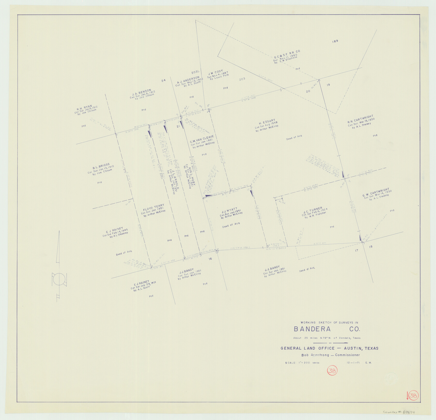
Bandera County Working Sketch 38
-
Map/Doc
67634
-
Collection
General Map Collection
-
Object Dates
12/1/1971 (Creation Date)
-
People and Organizations
Elbert Menzel (Draftsman)
Bob Armstrong (GLO Commissioner)
-
Counties
Bandera
-
Subjects
Surveying Working Sketch
-
Height x Width
30.4 x 31.5 inches
77.2 x 80.0 cm
-
Scale
1" = 200 varas
-
Comments
Surveys located about 25 miles North 78 degrees West of Bandera, Texas.
Part of: General Map Collection
Lipscomb County Rolled Sketch 5

Print $20.00
- Digital $50.00
Lipscomb County Rolled Sketch 5
1941
Size 45.8 x 23.3 inches
Map/Doc 9451
Coleman County Sketch File 45a

Print $4.00
- Digital $50.00
Coleman County Sketch File 45a
1897
Size 9.8 x 6.2 inches
Map/Doc 18791
Map of Cherokee County

Print $40.00
- Digital $50.00
Map of Cherokee County
1933
Size 55.0 x 38.7 inches
Map/Doc 95453
Nueces County Sketch File 37

Print $2.00
- Digital $50.00
Nueces County Sketch File 37
1913
Size 11.2 x 8.6 inches
Map/Doc 32614
Culberson County Working Sketch 24

Print $20.00
- Digital $50.00
Culberson County Working Sketch 24
1947
Size 36.8 x 36.2 inches
Map/Doc 68477
Brazoria County Rolled Sketch 34

Print $20.00
- Digital $50.00
Brazoria County Rolled Sketch 34
1944
Size 29.8 x 18.3 inches
Map/Doc 5171
Travis County Rolled Sketch 55

Print $40.00
- Digital $50.00
Travis County Rolled Sketch 55
Size 43.1 x 50.5 inches
Map/Doc 10020
Reeves County Rolled Sketch 4

Print $20.00
- Digital $50.00
Reeves County Rolled Sketch 4
1891
Size 23.9 x 39.6 inches
Map/Doc 7476
Burnet County Rolled Sketch 3

Print $20.00
- Digital $50.00
Burnet County Rolled Sketch 3
Size 23.7 x 26.2 inches
Map/Doc 5355
Crane County Working Sketch 15

Print $20.00
- Digital $50.00
Crane County Working Sketch 15
1946
Size 33.6 x 38.0 inches
Map/Doc 68292
Map of the State of Texas Showing Original Land Districts

Print $20.00
- Digital $50.00
Map of the State of Texas Showing Original Land Districts
1891
Size 43.7 x 43.3 inches
Map/Doc 73598
Flight Mission No. CUG-3P, Frame 18, Kleberg County

Print $20.00
- Digital $50.00
Flight Mission No. CUG-3P, Frame 18, Kleberg County
1956
Size 18.5 x 22.3 inches
Map/Doc 86228
You may also like
Smith County Rolled Sketch 6A3

Print $40.00
- Digital $50.00
Smith County Rolled Sketch 6A3
1990
Size 48.6 x 36.8 inches
Map/Doc 10698
Anderson County Working Sketch 11

Print $40.00
- Digital $50.00
Anderson County Working Sketch 11
1933
Size 42.8 x 57.9 inches
Map/Doc 67010
[Block O1, Godair]
![90565, [Block O1, Godair], Twichell Survey Records](https://historictexasmaps.com/wmedia_w700/maps/90565-1.tif.jpg)
Print $20.00
- Digital $50.00
[Block O1, Godair]
Size 22.6 x 17.7 inches
Map/Doc 90565
A Map of Gonzales County

Print $20.00
- Digital $50.00
A Map of Gonzales County
1838
Size 34.7 x 39.2 inches
Map/Doc 16838
Lampasas County Sketch File 19

Print $4.00
- Digital $50.00
Lampasas County Sketch File 19
1888
Size 10.3 x 8.2 inches
Map/Doc 29432
Liberty County Rolled Sketch 12

Print $20.00
- Digital $50.00
Liberty County Rolled Sketch 12
1983
Size 26.5 x 22.6 inches
Map/Doc 6618
[Beaumont, Sour Lake and Western Ry. Right of Way and Alignment - Frisco]
![64127, [Beaumont, Sour Lake and Western Ry. Right of Way and Alignment - Frisco], General Map Collection](https://historictexasmaps.com/wmedia_w700/maps/64127.tif.jpg)
Print $20.00
- Digital $50.00
[Beaumont, Sour Lake and Western Ry. Right of Way and Alignment - Frisco]
1910
Size 20.1 x 45.8 inches
Map/Doc 64127
Jim Hogg County Working Sketch 6

Print $40.00
- Digital $50.00
Jim Hogg County Working Sketch 6
1961
Size 63.3 x 42.8 inches
Map/Doc 66592
Gregg County Rolled Sketch 18A

Print $313.00
- Digital $50.00
Gregg County Rolled Sketch 18A
1934
Size 10.5 x 15.5 inches
Map/Doc 45469
Val Verde County Sketch File C

Print $62.00
- Digital $50.00
Val Verde County Sketch File C
1898
Size 15.5 x 19.8 inches
Map/Doc 12545
Map of Kendall County

Print $20.00
- Digital $50.00
Map of Kendall County
1899
Size 36.8 x 34.2 inches
Map/Doc 66887
Harrison County Sketch File 11

Print $22.00
- Digital $50.00
Harrison County Sketch File 11
1904
Size 9.2 x 9.3 inches
Map/Doc 26052