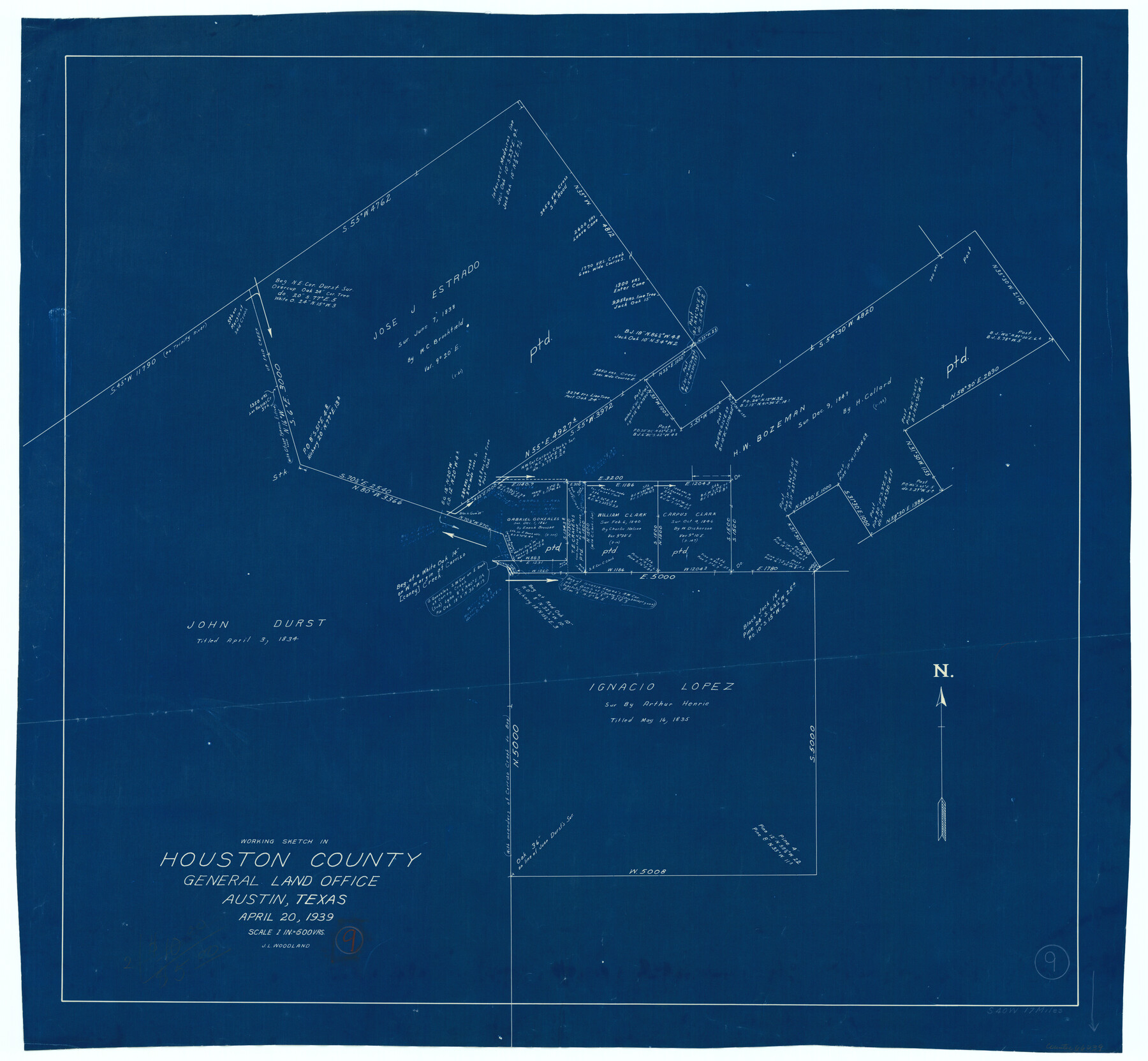
Houston County Working Sketch 9
-
Map/Doc
66239
-
Collection
General Map Collection
-
Object Dates
4/20/1939 (Creation Date)
-
People and Organizations
J.L. Woodland (Draftsman)
-
Counties
Houston
-
Subjects
Surveying Working Sketch
-
Height x Width
28.9 x 31.3 inches
73.4 x 79.5 cm
-
Scale
1" = 600 varas
Part of: General Map Collection
Edwards County Working Sketch 34

Print $20.00
- Digital $50.00
Edwards County Working Sketch 34
1948
Size 39.2 x 23.3 inches
Map/Doc 68910
Mexico or New Spain in which the Motions of Cortes may be traced

Print $20.00
- Digital $50.00
Mexico or New Spain in which the Motions of Cortes may be traced
1795
Size 14.5 x 16.5 inches
Map/Doc 93650
Liberty County Rolled Sketch 13

Print $20.00
- Digital $50.00
Liberty County Rolled Sketch 13
1983
Size 27.0 x 37.8 inches
Map/Doc 6619
Jeff Davis County Working Sketch 19

Print $40.00
- Digital $50.00
Jeff Davis County Working Sketch 19
1957
Size 71.3 x 34.1 inches
Map/Doc 66514
Roberts County Working Sketch 14

Print $20.00
- Digital $50.00
Roberts County Working Sketch 14
1975
Size 23.1 x 24.6 inches
Map/Doc 63540

Galveston County Sketch File 12

Print $6.00
- Digital $50.00
Galveston County Sketch File 12
1886
Size 15.7 x 11.4 inches
Map/Doc 23380
Wilbarger County Sketch File 18

Print $12.00
- Digital $50.00
Wilbarger County Sketch File 18
1886
Size 14.3 x 8.8 inches
Map/Doc 40209
Gillespie County Sketch File 14

Print $6.00
- Digital $50.00
Gillespie County Sketch File 14
1880
Size 10.1 x 11.4 inches
Map/Doc 24155
Dallas County Sketch File 12

Print $20.00
- Digital $50.00
Dallas County Sketch File 12
1853
Size 25.4 x 25.2 inches
Map/Doc 11284
Mustang Island

Print $20.00
- Digital $50.00
Mustang Island
1908
Size 34.8 x 26.2 inches
Map/Doc 78670
Crockett County Sketch File 12

Print $20.00
- Digital $50.00
Crockett County Sketch File 12
Size 26.8 x 18.9 inches
Map/Doc 11216
You may also like
Map of Hunt Co.

Print $40.00
- Digital $50.00
Map of Hunt Co.
1894
Size 49.7 x 30.0 inches
Map/Doc 16855
Ward County Sketch File 12

Print $4.00
- Digital $50.00
Ward County Sketch File 12
Size 14.3 x 8.8 inches
Map/Doc 39638
Flight Mission No. BRA-8M, Frame 141, Jefferson County

Print $20.00
- Digital $50.00
Flight Mission No. BRA-8M, Frame 141, Jefferson County
1953
Size 18.8 x 22.4 inches
Map/Doc 85633
Zapata County Working Sketch Graphic Index, Sheet 1 (Sketches 1 to 18)

Print $40.00
- Digital $50.00
Zapata County Working Sketch Graphic Index, Sheet 1 (Sketches 1 to 18)
1935
Size 55.3 x 41.3 inches
Map/Doc 76749

Hamilton County Sketch File 20

Print $26.00
- Digital $50.00
Hamilton County Sketch File 20
1935
Size 14.4 x 9.1 inches
Map/Doc 24942
Trinity River, Eagle Ford Sheet/Trinity and Elm Fork of Trinity River

Print $20.00
- Digital $50.00
Trinity River, Eagle Ford Sheet/Trinity and Elm Fork of Trinity River
1917
Size 29.5 x 23.2 inches
Map/Doc 69685
Montgomery County Rolled Sketch 40

Print $393.00
- Digital $50.00
Montgomery County Rolled Sketch 40
1970
Size 10.3 x 16.0 inches
Map/Doc 46793
Maps of Gulf Intracoastal Waterway, Texas - Sabine River to the Rio Grande and connecting waterways including ship channels

Print $20.00
- Digital $50.00
Maps of Gulf Intracoastal Waterway, Texas - Sabine River to the Rio Grande and connecting waterways including ship channels
1966
Size 14.6 x 22.2 inches
Map/Doc 61976
Upton County Working Sketch 57

Print $20.00
- Digital $50.00
Upton County Working Sketch 57
1988
Size 28.9 x 37.4 inches
Map/Doc 69554
El Paso County Rolled Sketch 57A

Print $40.00
- Digital $50.00
El Paso County Rolled Sketch 57A
1984
Size 49.2 x 39.4 inches
Map/Doc 8879
Aransas Pass to Baffin Bay

Print $20.00
- Digital $50.00
Aransas Pass to Baffin Bay
1966
Size 42.3 x 35.0 inches
Map/Doc 73415