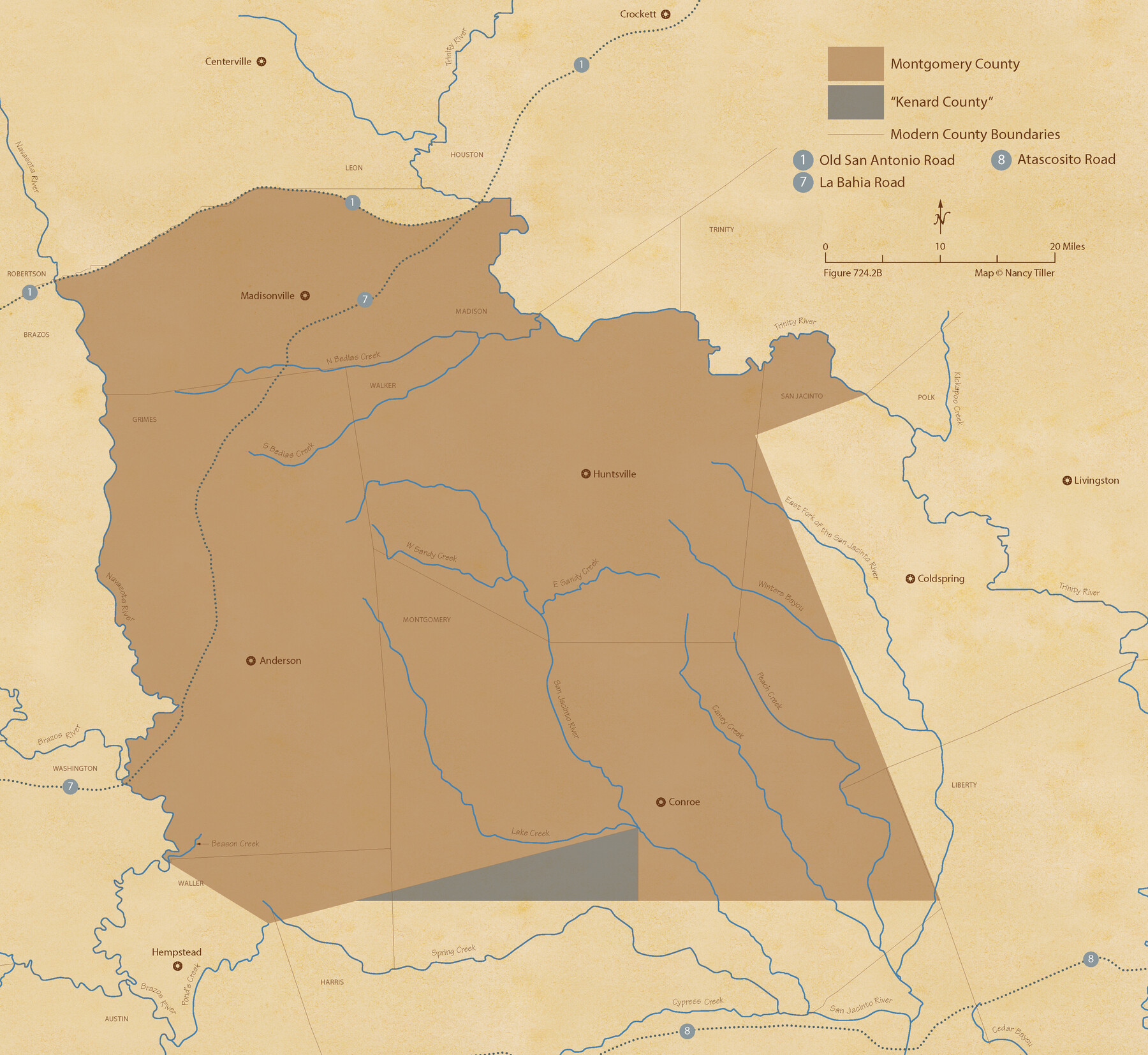
The Republic County of Montgomery. December 18, 1837
Figure No. 724.2 from 'A Boundary Atlas of Texas, 1821-1845' by Jim Tiller
-
Map/Doc
96235
-
Collection
Nancy and Jim Tiller Digital Collection
-
Object Dates
2020/1/1 (Creation Date)
-
People and Organizations
Jim Tiller (Author)
Nancy Tiller (Cartographer)
Gang Gong (GIS Professional)
-
Counties
Montgomery
-
Subjects
Atlas County Republic of Texas Texas Boundaries
-
Height x Width
19.9 x 21.7 inches
50.6 x 55.1 cm
-
Medium
digital image
-
Comments
To purchase a digital PDF copy of "A Boundary Atlas of Texas, 1821-1845" see 96437.
Part of: Nancy and Jim Tiller Digital Collection
The Land Offices. December 22, 1836

Print $20.00
The Land Offices. December 22, 1836
2020
Size 24.7 x 21.7 inches
Map/Doc 96425
From Citizens of Red River County for the Creation of a New County to be Called Aurora, December 3, 1840

Print $20.00
From Citizens of Red River County for the Creation of a New County to be Called Aurora, December 3, 1840
2020
Size 19.8 x 21.7 inches
Map/Doc 96391
From Citizens of Colorado and Matagorda Counties for the Creation of a New County (Unnamed), August 6, 1840

Print $20.00
From Citizens of Colorado and Matagorda Counties for the Creation of a New County (Unnamed), August 6, 1840
2020
Size 18.5 x 21.7 inches
Map/Doc 96389
The Republic County of Victoria. Proposed, Late Fall 1837

Print $20.00
The Republic County of Victoria. Proposed, Late Fall 1837
2020
Size 22.5 x 21.7 inches
Map/Doc 96294
The Republic County of Brazoria. Proposed, Late Fall 1837-January 1, 1838

Print $20.00
The Republic County of Brazoria. Proposed, Late Fall 1837-January 1, 1838
2020
Size 13.0 x 21.7 inches
Map/Doc 96110
The Peters Colony. November 9, 1841

Print $20.00
The Peters Colony. November 9, 1841
2020
Size 21.7 x 21.7 inches
Map/Doc 96363
The Republic County of Jackson. Boundaries Defined, December 29, 1837

Print $20.00
The Republic County of Jackson. Boundaries Defined, December 29, 1837
2020
Size 15.6 x 21.8 inches
Map/Doc 96184
The Republic County of Harrison. December 31, 1844

Print $20.00
The Republic County of Harrison. December 31, 1844
2020
Size 18.6 x 21.7 inches
Map/Doc 96176
The Mexican Municipality of Washington. Proposed Creation, ca Spring 1835

Print $20.00
The Mexican Municipality of Washington. Proposed Creation, ca Spring 1835
2020
Size 13.1 x 21.7 inches
Map/Doc 96035
The Republic County of Montgomery. Spring 1842

Print $20.00
The Republic County of Montgomery. Spring 1842
2020
Size 19.9 x 21.7 inches
Map/Doc 96240
The Republic County of Harris. January 25, 1840

Print $20.00
The Republic County of Harris. January 25, 1840
2020
Size 17.7 x 21.7 inches
Map/Doc 96165
The Land Offices. No. 9, Gonzales, December 22, 1836

Print $20.00
The Land Offices. No. 9, Gonzales, December 22, 1836
2020
Size 22.3 x 21.7 inches
Map/Doc 96422
You may also like
Flight Mission No. DAG-18K, Frame 184, Matagorda County

Print $20.00
- Digital $50.00
Flight Mission No. DAG-18K, Frame 184, Matagorda County
1952
Size 18.6 x 22.4 inches
Map/Doc 86376
Public Land on Mustang Island, Nueces County

Print $20.00
- Digital $50.00
Public Land on Mustang Island, Nueces County
1910
Size 17.0 x 17.5 inches
Map/Doc 93362
Andrews County Rolled Sketch 12B

Print $20.00
- Digital $50.00
Andrews County Rolled Sketch 12B
1933
Size 39.9 x 37.8 inches
Map/Doc 8392
Roberts County Working Sketch 5

Print $20.00
- Digital $50.00
Roberts County Working Sketch 5
1949
Size 40.4 x 40.1 inches
Map/Doc 63531
General Highway Map. Detail of Cities and Towns in Harris County, Texas

Print $20.00
General Highway Map. Detail of Cities and Towns in Harris County, Texas
1939
Size 18.3 x 24.7 inches
Map/Doc 79120
Rains County Boundary File 1

Print $6.00
- Digital $50.00
Rains County Boundary File 1
Size 11.3 x 8.8 inches
Map/Doc 58090
Preliminary Chart of the Entrance to Matagorda Bay, Texas

Print $20.00
Preliminary Chart of the Entrance to Matagorda Bay, Texas
1857
Size 20.2 x 32.9 inches
Map/Doc 76247
McCulloch County Sketch File 6

Print $20.00
- Digital $50.00
McCulloch County Sketch File 6
1893
Size 44.2 x 19.3 inches
Map/Doc 10539
Grimes County Working Sketch Graphic Index

Print $40.00
- Digital $50.00
Grimes County Working Sketch Graphic Index
1922
Size 54.9 x 29.4 inches
Map/Doc 76560
Sutton County Sketch File 8

Print $20.00
- Digital $50.00
Sutton County Sketch File 8
1891
Size 24.9 x 31.6 inches
Map/Doc 12379
Navigation Maps of Gulf Intracoastal Waterway, Port Arthur to Brownsville, Texas

Print $4.00
- Digital $50.00
Navigation Maps of Gulf Intracoastal Waterway, Port Arthur to Brownsville, Texas
1951
Size 16.7 x 21.6 inches
Map/Doc 65426
Outer Continental Shelf Leasing Maps (Texas Offshore Operations)

Print $20.00
- Digital $50.00
Outer Continental Shelf Leasing Maps (Texas Offshore Operations)
1954
Size 14.6 x 15.6 inches
Map/Doc 75836