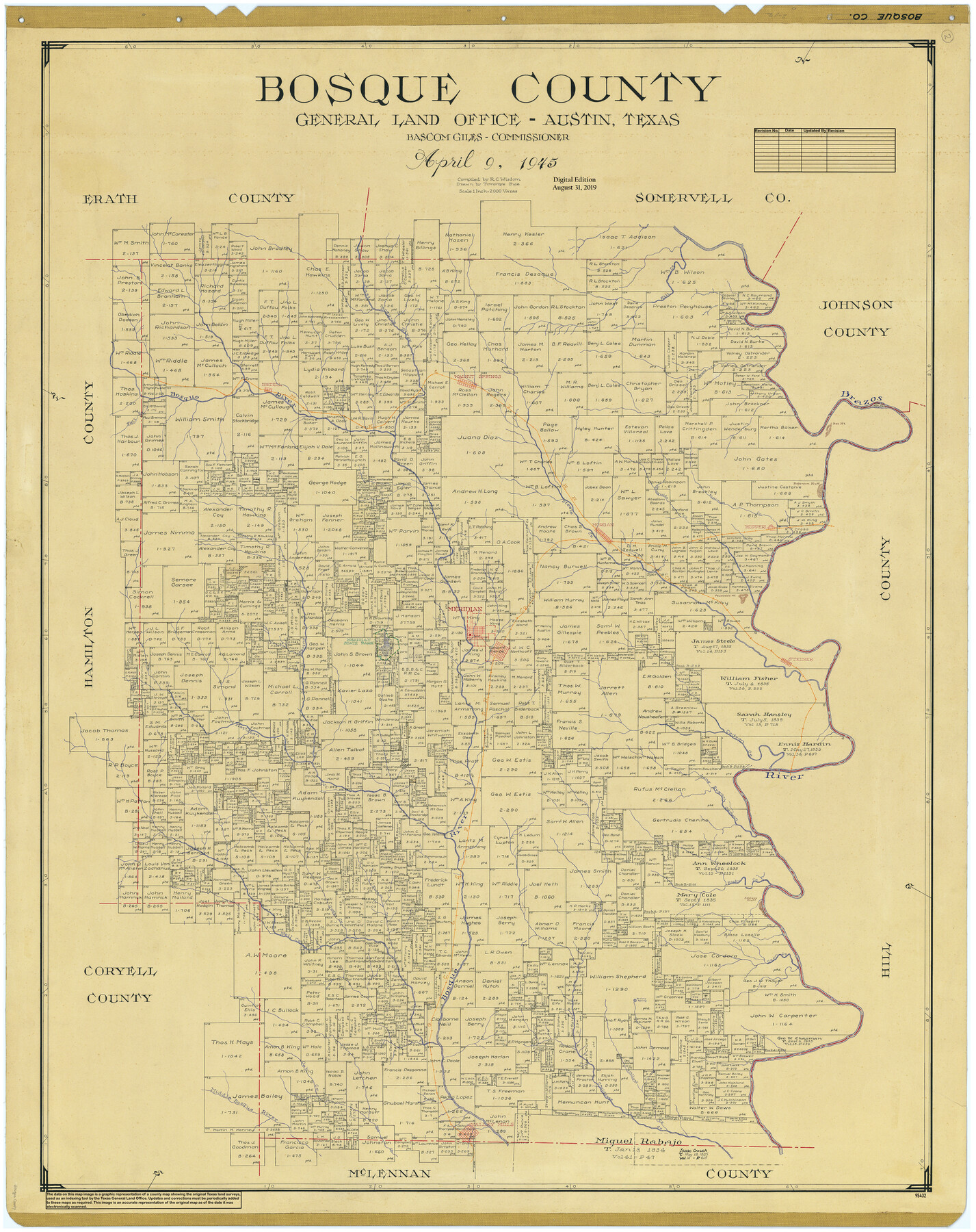
Bosque County
General Land Office Official County Map
-
Map/Doc
95432
-
Collection
General Map Collection
-
Object Dates
2019/8/31 (Revision Date)
1945/4/9 (Creation Date)
-
People and Organizations
Cheyenne Betancourt (Draftsman)
Tommye Buie (Draftsman)
R.C. Wisdom (Compiler)
Bascom Giles (GLO Commissioner)
-
Counties
Bosque
-
Subjects
County OCM
-
Height x Width
48.8 x 38.7 inches
124.0 x 98.3 cm
-
Medium
digital image
-
Scale
1" = 2000 varas
Part of: General Map Collection
Flight Mission No. CRC-1R, Frame 155, Chambers County

Print $20.00
- Digital $50.00
Flight Mission No. CRC-1R, Frame 155, Chambers County
1956
Size 18.8 x 22.4 inches
Map/Doc 84717
Val Verde County Working Sketch 44

Print $40.00
- Digital $50.00
Val Verde County Working Sketch 44
1945
Size 49.7 x 39.5 inches
Map/Doc 72179
Concho County Sketch File 45

Print $6.00
- Digital $50.00
Concho County Sketch File 45
1958
Size 11.2 x 8.8 inches
Map/Doc 19210
Cottle County Sketch File KN

Print $20.00
- Digital $50.00
Cottle County Sketch File KN
Size 18.8 x 25.2 inches
Map/Doc 11203
Galveston County NRC Article 33.136 Sketch 55A

Print $28.00
- Digital $50.00
Galveston County NRC Article 33.136 Sketch 55A
2009
Size 24.0 x 36.0 inches
Map/Doc 94616
Bee County Working Sketch 7

Print $20.00
- Digital $50.00
Bee County Working Sketch 7
1939
Size 17.8 x 20.6 inches
Map/Doc 67257
Karnes County

Print $20.00
- Digital $50.00
Karnes County
1921
Size 44.3 x 39.6 inches
Map/Doc 95551
Preliminary Chart of Entrance to Brazos River, Texas

Print $20.00
- Digital $50.00
Preliminary Chart of Entrance to Brazos River, Texas
Size 17.6 x 19.8 inches
Map/Doc 81986
Uvalde County Sketch File 22

Print $30.00
- Digital $50.00
Uvalde County Sketch File 22
1919
Size 9.7 x 8.6 inches
Map/Doc 39008
Karnes County Boundary File 5a

Print $4.00
- Digital $50.00
Karnes County Boundary File 5a
Size 8.1 x 13.3 inches
Map/Doc 55721
Hansford County Boundary File 1

Print $24.00
- Digital $50.00
Hansford County Boundary File 1
Size 9.2 x 8.6 inches
Map/Doc 54232
Pecos County Rolled Sketch 152

Print $20.00
- Digital $50.00
Pecos County Rolled Sketch 152
1960
Size 38.8 x 43.7 inches
Map/Doc 9736
You may also like
Orange County Sketch File B

Print $20.00
- Digital $50.00
Orange County Sketch File B
1890
Size 17.6 x 26.0 inches
Map/Doc 12130
Flight Mission No. CRC-3R, Frame 13, Chambers County

Print $20.00
- Digital $50.00
Flight Mission No. CRC-3R, Frame 13, Chambers County
1956
Size 18.5 x 22.3 inches
Map/Doc 84787
Wichita County Working Sketch 13

Print $20.00
- Digital $50.00
Wichita County Working Sketch 13
1921
Size 16.5 x 32.8 inches
Map/Doc 72523
Rusk County Rolled Sketch 5

Print $40.00
- Digital $50.00
Rusk County Rolled Sketch 5
1948
Size 36.9 x 49.5 inches
Map/Doc 10744
Zapata County Working Sketch Graphic Index, Sheet 1 (Sketches 1 to 18)

Print $40.00
- Digital $50.00
Zapata County Working Sketch Graphic Index, Sheet 1 (Sketches 1 to 18)
1935
Size 55.3 x 41.3 inches
Map/Doc 76749
Garza County Sketch File 25a

Print $14.00
- Digital $50.00
Garza County Sketch File 25a
Size 11.4 x 8.8 inches
Map/Doc 24088
Tom Green County Working Sketch 2

Print $20.00
- Digital $50.00
Tom Green County Working Sketch 2
1917
Size 21.1 x 32.9 inches
Map/Doc 69371
[T. & P. Blocks 31-36, Townships 1N-5N]
![93054, [T. & P. Blocks 31-36, Townships 1N-5N], Twichell Survey Records](https://historictexasmaps.com/wmedia_w700/maps/93054-1.tif.jpg)
Print $20.00
- Digital $50.00
[T. & P. Blocks 31-36, Townships 1N-5N]
Size 14.2 x 17.4 inches
Map/Doc 93054
Stonewall County Sketch File 14

Print $20.00
- Digital $50.00
Stonewall County Sketch File 14
1901
Size 21.5 x 18.3 inches
Map/Doc 12366
Treaty to Resolve Pending Boundary Differences and Maintain the Rio Grande and Colorado River as the International Boundary Between the United States of American and Mexico

Print $20.00
- Digital $50.00
Treaty to Resolve Pending Boundary Differences and Maintain the Rio Grande and Colorado River as the International Boundary Between the United States of American and Mexico
1970
Size 11.1 x 35.8 inches
Map/Doc 83102

The Rand-McNally New Commercial Atlas Map of Texas

The Rand-McNally New Commercial Atlas Map of Texas
1914
Size 29.4 x 40.7 inches
Map/Doc 88745