Nueces County Sketch File 65
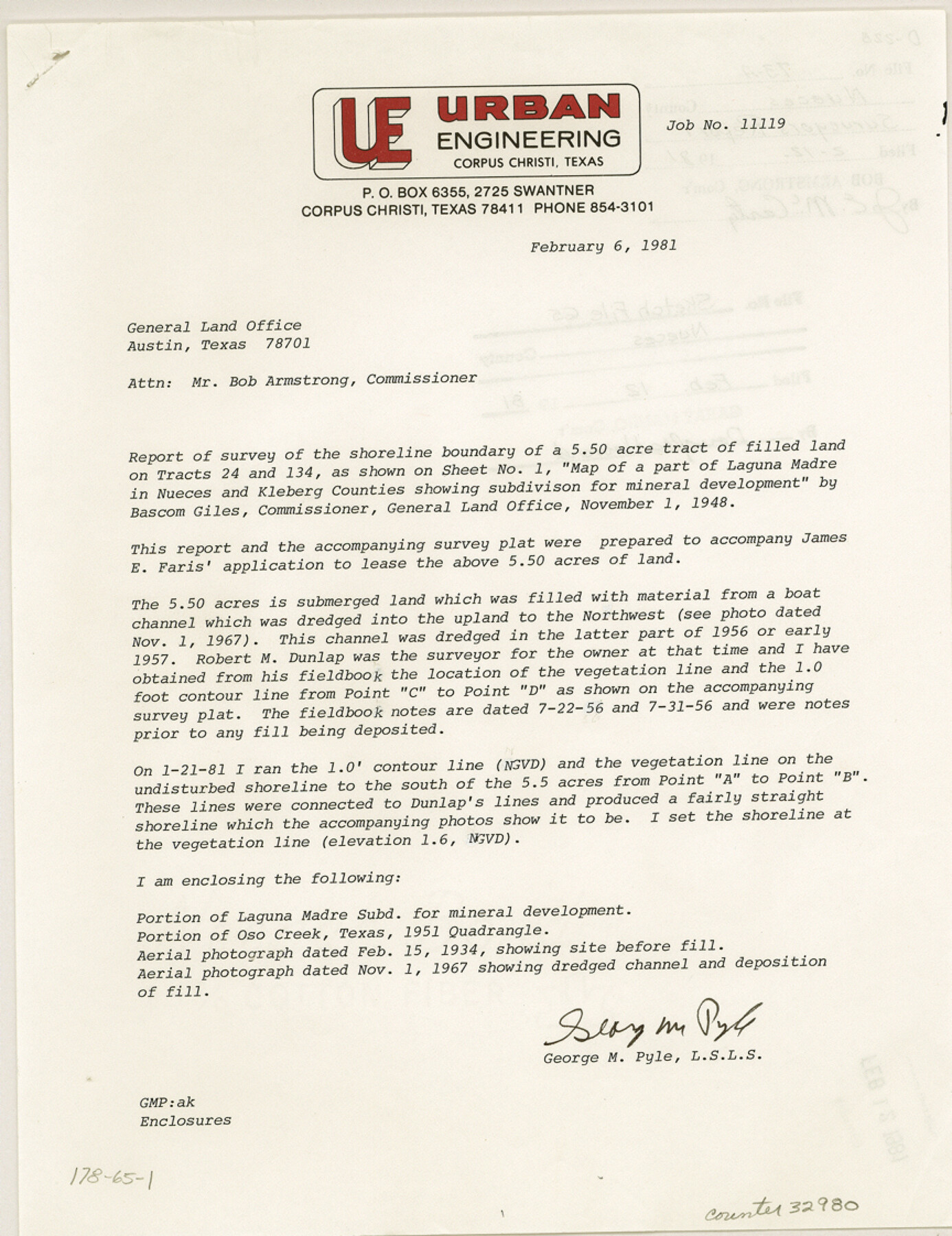
[Report of survey of the shoreline boundary of a 5.50 acre tract of filled land on tracts 24 and 134]
-
Map/Doc
32980
-
Collection
General Map Collection
-
Object Dates
2/1981 (Creation Date)
2/12/1981 (File Date)
-
People and Organizations
George M. Pyle (Surveyor/Engineer)
Bascom Giles (GLO Commissioner)
Robert M. Dunlap (Surveyor/Engineer)
Herman Forbes (Surveyor/Engineer)
Curtis R. Hale (Surveyor/Engineer)
-
Counties
Nueces
-
Subjects
Surveying Sketch File
-
Height x Width
11.2 x 8.6 inches
28.5 x 21.8 cm
-
Medium
multi-page, multi-format
-
Comments
See Nueces County Rolled Sketch 73 (6931) for sketch.
-
Features
Ocean Drive
Daybeacon
Pita Island
Waldron Field
Flour Bluff Cemetery
Dug
Mud Bridge
Encinal Peninsula
Peary Place
Laguna Madre
Sundeen High School
Flour Bluff
Corpus Christi Naval Air Station
Oso Bay
Ward Island
San Patricio Causeway Lighthouse
U.S. Naval Air Station
Laguna Madre Subdivision
Related maps
Nueces County Rolled Sketch 73

Print $20.00
- Digital $50.00
Nueces County Rolled Sketch 73
1981
Size 24.2 x 36.0 inches
Map/Doc 6931
Part of: General Map Collection
Eastland County Sketch File 22

Print $33.00
- Digital $50.00
Eastland County Sketch File 22
1964
Size 11.0 x 17.0 inches
Map/Doc 21626
Hansford County

Print $20.00
- Digital $50.00
Hansford County
1932
Size 39.6 x 38.5 inches
Map/Doc 77301
Real County Working Sketch 63

Print $20.00
- Digital $50.00
Real County Working Sketch 63
1967
Size 28.8 x 32.3 inches
Map/Doc 71955
Brewster County Working Sketch 9

Print $20.00
- Digital $50.00
Brewster County Working Sketch 9
1910
Size 14.3 x 14.4 inches
Map/Doc 67542
Victoria County Sketch File 8

Print $2.00
- Digital $50.00
Victoria County Sketch File 8
Size 5.7 x 5.6 inches
Map/Doc 39524
Map of a Part of Robertson Colony

Print $20.00
- Digital $50.00
Map of a Part of Robertson Colony
1843
Size 32.2 x 22.6 inches
Map/Doc 168
Matagorda County Rolled Sketch 36

Print $115.00
- Digital $50.00
Matagorda County Rolled Sketch 36
1944
Size 10.1 x 15.0 inches
Map/Doc 46747
Intracoastal Waterway in Texas - Corpus Christi to Point Isabel including Arroyo Colorado to Mo. Pac. R.R. Bridge Near Harlingen

Print $20.00
- Digital $50.00
Intracoastal Waterway in Texas - Corpus Christi to Point Isabel including Arroyo Colorado to Mo. Pac. R.R. Bridge Near Harlingen
1933
Size 27.9 x 40.8 inches
Map/Doc 61862
Morris County Working Sketch 1

Print $20.00
- Digital $50.00
Morris County Working Sketch 1
1948
Size 31.2 x 28.0 inches
Map/Doc 71200
Flight Mission No. DAG-17K, Frame 64, Matagorda County

Print $20.00
- Digital $50.00
Flight Mission No. DAG-17K, Frame 64, Matagorda County
1952
Size 16.5 x 16.4 inches
Map/Doc 86326
Treaty to Resolve Pending Boundary Differences and Maintain the Rio Grande and Colorado River as the International Boundary Between the United States of American and Mexico

Print $20.00
- Digital $50.00
Treaty to Resolve Pending Boundary Differences and Maintain the Rio Grande and Colorado River as the International Boundary Between the United States of American and Mexico
1970
Size 11.0 x 35.3 inches
Map/Doc 83103
Webb County Working Sketch 9

Print $20.00
- Digital $50.00
Webb County Working Sketch 9
1911
Size 17.2 x 30.8 inches
Map/Doc 72374
You may also like
San Patricio County Sketch File 18

Print $4.00
San Patricio County Sketch File 18
Size 6.2 x 8.3 inches
Map/Doc 36066
Uvalde County Sketch File 29

Print $8.00
- Digital $50.00
Uvalde County Sketch File 29
1873
Size 13.0 x 8.3 inches
Map/Doc 39028
Stephens County Working Sketch 11

Print $20.00
- Digital $50.00
Stephens County Working Sketch 11
1921
Size 21.0 x 16.5 inches
Map/Doc 63954
Henderson County Sketch File 18

Print $20.00
- Digital $50.00
Henderson County Sketch File 18
1936
Size 16.7 x 18.3 inches
Map/Doc 11756
Zapata County Working Sketch 9

Print $20.00
- Digital $50.00
Zapata County Working Sketch 9
1951
Size 34.9 x 18.1 inches
Map/Doc 62060
Bandera County Working Sketch 60

Print $20.00
- Digital $50.00
Bandera County Working Sketch 60
2004
Size 32.1 x 43.6 inches
Map/Doc 83562
Map of Coryell Co.

Print $40.00
- Digital $50.00
Map of Coryell Co.
1896
Size 49.8 x 43.1 inches
Map/Doc 4921
General Highway Map, Newton County, Texas

Print $20.00
General Highway Map, Newton County, Texas
1961
Size 19.3 x 25.0 inches
Map/Doc 79612
El Paso County Rolled Sketch 61

Print $20.00
- Digital $50.00
El Paso County Rolled Sketch 61
1994
Size 27.8 x 39.0 inches
Map/Doc 5853
Mrs. Alex A. Slaughter Ranch Hockley County, Texas

Print $20.00
- Digital $50.00
Mrs. Alex A. Slaughter Ranch Hockley County, Texas
Size 26.2 x 19.7 inches
Map/Doc 92237
Hunt County Working Sketch 2

Print $20.00
- Digital $50.00
Hunt County Working Sketch 2
Size 20.5 x 16.5 inches
Map/Doc 66349
Wise County Working Sketch Graphic Index

Print $20.00
- Digital $50.00
Wise County Working Sketch Graphic Index
1942
Size 44.9 x 37.9 inches
Map/Doc 76745