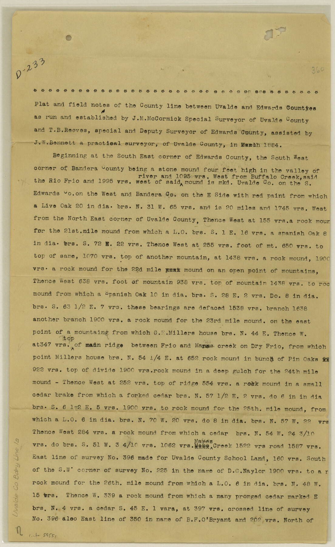
Uvalde County Boundary File 1a
Field notes of County line between Uvalde and Edwards Counties Certified Copy
-
Map/Doc
59551
-
Collection
General Map Collection
-
Counties
Uvalde
-
Subjects
County Boundaries
-
Height x Width
14.5 x 8.9 inches
36.8 x 22.6 cm
Part of: General Map Collection
Dallas County Boundary File 6a

Print $36.00
- Digital $50.00
Dallas County Boundary File 6a
Size 14.0 x 8.6 inches
Map/Doc 52189
Webb County Sketch File 66

Print $20.00
- Digital $50.00
Webb County Sketch File 66
1950
Size 13.4 x 20.6 inches
Map/Doc 12655
Palo Pinto County Boundary File 3

Print $58.00
- Digital $50.00
Palo Pinto County Boundary File 3
Size 14.3 x 8.7 inches
Map/Doc 57800
Flight Mission No. CGI-1N, Frame 213, Cameron County

Print $20.00
- Digital $50.00
Flight Mission No. CGI-1N, Frame 213, Cameron County
1955
Size 18.5 x 22.2 inches
Map/Doc 84522
Map of Orange County

Print $20.00
- Digital $50.00
Map of Orange County
1862
Size 13.6 x 16.5 inches
Map/Doc 3929
Nueces County Rolled Sketch 91

Print $79.00
Nueces County Rolled Sketch 91
1983
Size 24.6 x 37.2 inches
Map/Doc 7017
[Coastal Chart of Galveston Island, Bolivar Peninsula and Galveston Bay]
![61804, [Coastal Chart of Galveston Island, Bolivar Peninsula and Galveston Bay], General Map Collection](https://historictexasmaps.com/wmedia_w700/maps/61804.tif.jpg)
Print $20.00
- Digital $50.00
[Coastal Chart of Galveston Island, Bolivar Peninsula and Galveston Bay]
Size 24.0 x 18.1 inches
Map/Doc 61804
Pecos County Working Sketch 93

Print $40.00
- Digital $50.00
Pecos County Working Sketch 93
1966
Size 32.1 x 71.5 inches
Map/Doc 71566
Orange County Sketch File 13

Print $6.00
- Digital $50.00
Orange County Sketch File 13
1885
Size 11.3 x 9.7 inches
Map/Doc 33326
Harris County Sketch File 100

Print $518.00
- Digital $50.00
Harris County Sketch File 100
1991
Size 11.5 x 8.8 inches
Map/Doc 25674
Grimes County Rolled Sketch 1

Print $20.00
- Digital $50.00
Grimes County Rolled Sketch 1
1945
Size 34.6 x 35.0 inches
Map/Doc 9007
Motley County Sketch File 24 (S)

Print $4.00
- Digital $50.00
Motley County Sketch File 24 (S)
Size 9.2 x 7.1 inches
Map/Doc 32204
You may also like
Val Verde County Sketch File Z23

Print $6.00
- Digital $50.00
Val Verde County Sketch File Z23
1919
Size 7.3 x 8.8 inches
Map/Doc 39166
Map of Wolters Addition to Big Lake Reagan County, Texas Showing the Original Townsite of Big Lake and Japson's Addition

Print $40.00
- Digital $50.00
Map of Wolters Addition to Big Lake Reagan County, Texas Showing the Original Townsite of Big Lake and Japson's Addition
1948
Size 42.4 x 49.6 inches
Map/Doc 89712
Map of Reeves County

Print $20.00
- Digital $50.00
Map of Reeves County
1892
Size 44.8 x 34.0 inches
Map/Doc 3983
[Sketch showing Block H, Section 11 of Roberts County, including the south bank of the Canadian River]
![91761, [Sketch showing Block H, Section 11 of Roberts County, including the south bank of the Canadian River], Twichell Survey Records](https://historictexasmaps.com/wmedia_w700/maps/91761-1.tif.jpg)
Print $2.00
- Digital $50.00
[Sketch showing Block H, Section 11 of Roberts County, including the south bank of the Canadian River]
1919
Size 14.4 x 8.8 inches
Map/Doc 91761
Hemphill County Working Sketch 16

Print $20.00
- Digital $50.00
Hemphill County Working Sketch 16
1971
Size 27.0 x 40.0 inches
Map/Doc 66111
Hardin County Working Sketch 30

Print $20.00
- Digital $50.00
Hardin County Working Sketch 30
1967
Size 24.6 x 20.3 inches
Map/Doc 63428
Freestone County Working Sketch 8

Print $40.00
- Digital $50.00
Freestone County Working Sketch 8
1960
Size 60.6 x 36.6 inches
Map/Doc 69250
Ochiltree County Working Sketch 2

Print $20.00
- Digital $50.00
Ochiltree County Working Sketch 2
1959
Size 23.9 x 20.8 inches
Map/Doc 71315
[H. & T. C. Block 47, Sections 47- 57, Part of Block B12]
![91527, [H. & T. C. Block 47, Sections 47- 57, Part of Block B12], Twichell Survey Records](https://historictexasmaps.com/wmedia_w700/maps/91527-1.tif.jpg)
Print $20.00
- Digital $50.00
[H. & T. C. Block 47, Sections 47- 57, Part of Block B12]
Size 16.2 x 22.6 inches
Map/Doc 91527

Wendlandt's Subdivision of part of Outlot 4, Division "Z"

Print $20.00
- Digital $50.00
Wendlandt's Subdivision of part of Outlot 4, Division "Z"
1910
Size 18.0 x 13.6 inches
Map/Doc 83428
[Blocks 1 and H]
![90719, [Blocks 1 and H], Twichell Survey Records](https://historictexasmaps.com/wmedia_w700/maps/90719-1.tif.jpg)
Print $20.00
- Digital $50.00
[Blocks 1 and H]
Size 27.1 x 21.6 inches
Map/Doc 90719