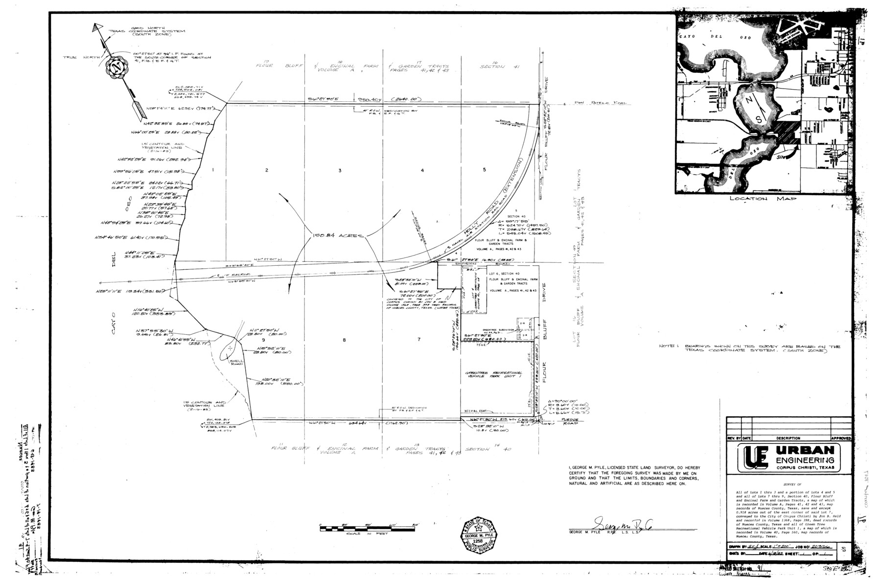
Nueces County Rolled Sketch 91
[Sketch, report, and exhibits regarding a shoreline survey of a 150.84 acre tract of land out of Section 40, Flour Bluff and Encinal Farm and Garden Tracts]
-
Map/Doc
7017
-
Collection
General Map Collection
-
Object Dates
1983 (Creation Date)
-
People and Organizations
George M. Pyle (Surveyor/Engineer)
-
Counties
Nueces
-
Subjects
Surveying Rolled Sketch
-
Height x Width
24.6 x 37.2 inches
62.5 x 94.5 cm
Part of: General Map Collection
Pecos County Sketch File 1

Print $20.00
- Digital $50.00
Pecos County Sketch File 1
Size 8.9 x 4.0 inches
Map/Doc 33642
Travis County Working Sketch 46

Print $20.00
- Digital $50.00
Travis County Working Sketch 46
1981
Size 46.6 x 36.9 inches
Map/Doc 69430
Edwards County Working Sketch 89

Print $40.00
- Digital $50.00
Edwards County Working Sketch 89
1966
Size 49.7 x 28.8 inches
Map/Doc 68965
Tom Green County Rolled Sketch 48

Print $20.00
- Digital $50.00
Tom Green County Rolled Sketch 48
1884
Size 14.3 x 22.7 inches
Map/Doc 8009
McCulloch County

Print $20.00
- Digital $50.00
McCulloch County
1874
Size 21.9 x 16.8 inches
Map/Doc 3856
Padre Island National Seashore

Print $4.00
- Digital $50.00
Padre Island National Seashore
Size 16.1 x 22.3 inches
Map/Doc 60535
Lamb County Sketch File 16

Print $4.00
- Digital $50.00
Lamb County Sketch File 16
1929
Size 11.2 x 8.8 inches
Map/Doc 29379
Starr County Boundary File 1

Print $24.00
- Digital $50.00
Starr County Boundary File 1
Size 13.0 x 8.5 inches
Map/Doc 58801
Right of Way and Track Map, The Missouri, Kansas and Texas Ry. of Texas operated by the Missouri, Kansas and Texas Ry. of Texas, Henrietta Division

Print $40.00
- Digital $50.00
Right of Way and Track Map, The Missouri, Kansas and Texas Ry. of Texas operated by the Missouri, Kansas and Texas Ry. of Texas, Henrietta Division
1918
Size 25.5 x 57.0 inches
Map/Doc 64071
[Texas & Pacific Railway through Callahan County]
![64235, [Texas & Pacific Railway through Callahan County], General Map Collection](https://historictexasmaps.com/wmedia_w700/maps/64235.tif.jpg)
Print $20.00
- Digital $50.00
[Texas & Pacific Railway through Callahan County]
1918
Size 23.2 x 8.3 inches
Map/Doc 64235
Eastland County Working Sketch 9

Print $20.00
- Digital $50.00
Eastland County Working Sketch 9
1919
Size 33.0 x 30.6 inches
Map/Doc 68790
Atascosa County Working Sketch 37

Print $20.00
- Digital $50.00
Atascosa County Working Sketch 37
2004
Size 23.2 x 24.1 inches
Map/Doc 89049
You may also like
Knox County Sketch File 6A

Print $20.00
- Digital $50.00
Knox County Sketch File 6A
1881
Size 32.3 x 18.2 inches
Map/Doc 11954
The Judicial District/County of Trinity. Abolished, Spring 1842

Print $20.00
The Judicial District/County of Trinity. Abolished, Spring 1842
2020
Size 14.7 x 21.7 inches
Map/Doc 96351
Nueces County Aerial Photograph Index Sheet 22

Print $20.00
- Digital $50.00
Nueces County Aerial Photograph Index Sheet 22
1938
Size 24.5 x 20.3 inches
Map/Doc 86843
Flight Mission No. BRA-7M, Frame 82, Jefferson County

Print $20.00
- Digital $50.00
Flight Mission No. BRA-7M, Frame 82, Jefferson County
1953
Size 16.1 x 15.9 inches
Map/Doc 85504
Township No. 5 South Range No. 9 West of the Indian Meridian

Print $20.00
- Digital $50.00
Township No. 5 South Range No. 9 West of the Indian Meridian
1874
Size 19.2 x 24.5 inches
Map/Doc 75135
Plan of Brooklyn

Print $20.00
- Digital $50.00
Plan of Brooklyn
1909
Size 42.7 x 31.5 inches
Map/Doc 2192
Flight Mission No. BQR-13K, Frame 162, Brazoria County

Print $20.00
- Digital $50.00
Flight Mission No. BQR-13K, Frame 162, Brazoria County
1952
Size 18.6 x 22.4 inches
Map/Doc 84087
Kerr County Working Sketch Graphic Index

Print $40.00
- Digital $50.00
Kerr County Working Sketch Graphic Index
1923
Size 40.4 x 55.9 inches
Map/Doc 76605
Flight Mission No. DAG-23K, Frame 18, Matagorda County

Print $20.00
- Digital $50.00
Flight Mission No. DAG-23K, Frame 18, Matagorda County
1953
Size 18.5 x 22.2 inches
Map/Doc 86480
Kimble County Working Sketch 2

Print $20.00
- Digital $50.00
Kimble County Working Sketch 2
Size 20.6 x 17.9 inches
Map/Doc 70070
San Patricio County Rolled Sketch 53

Print $20.00
- Digital $50.00
San Patricio County Rolled Sketch 53
1996
Size 19.1 x 25.3 inches
Map/Doc 7738
Concho County Sketch File 53

Print $8.00
- Digital $50.00
Concho County Sketch File 53
2002
Size 11.3 x 8.9 inches
Map/Doc 78515